
Image: Yasi feb 1 2011 0000Z

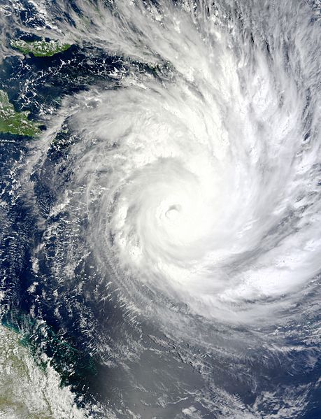
Description: On February 1, 2011, Tropical Cyclone Yasi continued on its path toward Queensland, Australia. The Moderate Resolution Imaging Spectroradiometer (MODIS) on NASA’s Terra satellite captured this natural-color image at 10:00 a.m. Queensland time (00:00 UTC) on February 1. The storm extends over the Solomon Islands (outlined in black) and grazes Papua New Guinea. Part of the Queensland coast appears in the lower left corner of the image. At 1:00 a.m. on February 2 Queensland time (15:00 on February 1 UTC), the U.S. Navy’s Joint Typhoon Warning Center (JTWC) reported that Yasi was roughly 450 nautical miles (835 kilometers) east-northeast of Cairns, Queensland, Australia. Sporting a well-defined eye, Yasi had maximum sustained winds of 120 knots (220 kilometers per hour) and gusts up to 145 knots (270 kilometers per hour). True to earlier forecasts, favorable conditions had enabled the storm to intensify rapidly over the Pacific Ocean. The JTWC forecast that Yasi would continue to strengthen and would remain on west-southwestward track. The storm was expected to make landfall just south of Cairns, bringing high winds and potentially high waves. The Sydney Morning Herald reported that tens of thousands of residents were evacuating ahead of the storm’s anticipated landfall late February 2 or early February 3.
Title: Yasi feb 1 2011 0000Z
Credit: http://rapidfire.sci.gsfc.nasa.gov/gallery/?2011032-0201/Yasi.A2011032.0000.2km.jpg
Author: NASA image by Jeff Schmaltz, MODIS Rapid Response Team at NASA GSFC. Caption by Michon Scott
Usage Terms: Public domain
License: Public domain
Attribution Required?: No
Image usage
The following page links to this image:
