
Immokalee, Florida facts for kids
Quick facts for kids
Immokalee, Florida
|
|
|---|---|
 |
|
| Etymology: Mikasuki: Immokalee (your home) | |

Location in Collier County and the state of Florida
|
|
| Country | United States |
| State | Florida |
| County | Collier |
| Area | |
| • Total | 23.29 sq mi (60.32 km2) |
| • Land | 22.72 sq mi (58.85 km2) |
| • Water | 0.57 sq mi (1.48 km2) 2.5% |
| Elevation | 33 ft (10 m) |
| Population
(2020)
|
|
| • Total | 24,557 |
| • Density | 1,080.81/sq mi (417.30/km2) |
| Time zone | UTC-5 (Eastern (EST)) |
| • Summer (DST) | UTC-4 (EDT) |
| ZIP codes |
34142–34143
|
| Area code(s) | 239 |
| FIPS code | 12-33250 |
| GNIS feature ID | 284474 |
Immokalee ( IH-mok-(Ə)-lee) is an unincorporated community and census-designated place in Collier County, Florida, United States.
Contents
History
Originally the region was occupied by the Calusa Indians and centuries later occupied by the Seminole, after they moved down from the northern part of Florida. Initially the settlement was known as Gopher Ridge by the Seminole and Miccosukee Indians. Immokalee means "My Home" in Mikasuki language.
When the swamps were drained in the region, agriculture became the dominant industry. European-American hunters, trappers, Indian traders, cowmen, and missionaries moved in before the development of permanent villages. The first permanent settlement was founded in 1872.
In 1921 the Atlantic Coast Line Railroad was extended south to Immokalee.
The Immokalee area is heavily agricultural. It is one of the major centers of tomato growing in the United States. In 1960, CBS News anchor Edward R. Murrow reported on the working conditions in the surrounding farms for his Harvest of Shame report for CBS Reports, which described the harsh lives of migrant workers.
Geography
Immokalee is located in northern Collier County along Florida State Road 29. LaBelle is 24 miles (39 km) to the north, and Interstate 75 (Alligator Alley) is 20 miles (32 km) to the south.
According to the United States Census Bureau, the CDP has a total area of 23.3 square miles (60.3 km2), of which 22.7 square miles (58.8 km2) is land and 0.58 square miles (1.5 km2), or 2.42%, is water.
Demographics
| Historical population | |||
|---|---|---|---|
| Census | Pop. | %± | |
| 1960 | 3,224 | — | |
| 1970 | 3,764 | 16.7% | |
| 1980 | 11,038 | 193.3% | |
| 1990 | 14,120 | 27.9% | |
| 2000 | 19,763 | 40.0% | |
| 2010 | 24,154 | 22.2% | |
| 2020 | 24,557 | 1.7% | |
| source: | |||
2020 census
| Race | Number | Percentage |
|---|---|---|
| White (NH) | 709 | 2.89% |
| Black or African American (NH) | 4,875 | 19.85% |
| Native American or Alaska Native (NH) | 70 | 0.29% |
| Asian (NH) | 37 | 0.15% |
| Pacific Islander (NH) | 3 | 0.01% |
| Some Other Race (NH) | 75 | 0.31% |
| Mixed/Multi-Racial (NH) | 239 | 0.97% |
| Hispanic or Latino | 18,549 | 75.53% |
| Total | 24,557 |
As of the 2020 United States census, there were 24,557 people, 5,985 households, and 4,517 families residing in the CDP.
2010 census
Immokalee's population was 24,154 at the 2010 census. It is part of the Naples–Marco Island Metropolitan Statistical Area.
Transportation
Immokalee Airport is a public-use general aviation airport 1 mile (1.6 km) northeast of the central business district.
Collier Area Transit provides local bus service and paratransit. The #5 connects to Naples, the #7 connects to Marco Island (limited trips), and the 8A circulates within the area.
Immokalee used to be served by the Seaboard Coast Line Railroad (formerly Atlantic Coast Line), which ran a branchline from Palmdale through Immokalee to Everglades City. The line generated considerable agricultural-related traffic. The line was cut back to Sunniland south of Immokalee in the 1950s and then abandoned to the mainline at Palmdale in the 1980s. This left Immokalee without rail service.
The main road through Immokalee is State Road 29. Other important county roads through the region are CR 29A and CR 846.
Education
Immokalee's public schools are operated by the District School Board of Collier County.
Elementary schools in Immokalee and serving Immokalee include Eden Park, Highlands, Lake Trafford, and Village Oaks. Pinecrest Elementary School, outside of and adjacent to the CDP, serves a portion of the CDP. All residents are zoned to Immokalee Middle School and Immokalee High School, both in the CDP.
Landmarks and institutions
The federally recognized Seminole Tribe of Florida has one of its six reservations here, Immokalee, on which it operates one of its gaming casinos.
The Audubon Society's Corkscrew Swamp Sanctuary is nearby.
Notable people
- D'Ernest Johnson, Cleveland Browns running back
- Mackensie Alexander, Cincinnati Bengals cornerback
- Albert Bentley, played football at Immokalee High School and went on to play for the Miami Hurricanes and the Indianapolis Colts
- J. C. Jackson, New England Patriots cornerback
- Edgerrin James, Hall of Fame running back (Indianapolis Colts)
- Javarris James, Indianapolis Colts running back
- Brian Rolle, Philadelphia Eagles linebacker
- Ovince Saint Preux, Ultimate Fighting Championship competitor
- Felipe Santos, missing person
- Deadrin Senat, Atlanta Falcons defensive tackle
Images for kids
-
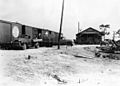
Former Atlantic Coast Line Railroad Immokalee Depot

See also
 In Spanish: Immokalee para niños
