
Imperial, California facts for kids
Quick facts for kids
Imperial, California
|
||
|---|---|---|
| City of Imperial | ||
  Top:Imperial City Hall ;
Bottom: Worthington Square Imperial |
||
|
||

Location of Imperial in Imperial County, California.
|
||

Imperial, California
Location in the United States
|
||
| Country | United States | |
| State | California | |
| County | Imperial | |
| Incorporated | July 12, 1904 | |
| Area | ||
| • City | 6.29 sq mi (16.29 km2) | |
| • Land | 6.29 sq mi (16.29 km2) | |
| • Water | 0.00 sq mi (0.00 km2) 0% | |
| Elevation | -59 ft (-18 m) | |
| Population
(2010)
|
||
| • City | 14,758 | |
| • Estimate
(2019)
|
18,120 | |
| • Density | 2,880.76/sq mi (1,112.18/km2) | |
| • Metro | 175,000 | |
| Time zone | UTC-8 (Pacific (PST)) | |
| • Summer (DST) | UTC-7 (PDT) | |
| ZIP code |
92251
|
|
| Area code | 442/760 | |
| FIPS code | 06-36280 | |
| GNIS feature IDs | 1652726, 2410097 | |

Imperial is a city in Imperial County, California, 4 miles (6.4 km) north of El Centro.
As of the 2010 census, the city had a population of 14,758. It is part of the El Centro metropolitan area. In 2016, Imperial was the fourth fastest-growing city in the state, gaining 4.1 percent more residents from January 1, 2015, to January 1, 2016. It compares to Imperial County's growth of 1.3 percent and Brawley's growth of 1.2 percent.
Contents
Geography
According to the United States Census Bureau, the city has a total area of 5.9 square miles (15 km2), all land.
Climate
Imperial has an arid desert climate, and is one of the hottest cities in the United States. In January, the normal high temperature is 70 degrees with a low of 42. In July, the normal high temperature is 110 degrees with a low of 82.
| Climate data for Imperial, CA | |||||||||||||
|---|---|---|---|---|---|---|---|---|---|---|---|---|---|
| Month | Jan | Feb | Mar | Apr | May | Jun | Jul | Aug | Sep | Oct | Nov | Dec | Year |
| Record high °F (°C) | 96 (36) |
96 (36) |
104 (40) |
109 (43) |
118 (48) |
123 (51) |
125 (52) |
124 (51) |
118 (48) |
111 (44) |
98 (37) |
90 (32) |
125 (52) |
| Average high °F (°C) | 69.8 (21.0) |
73.8 (23.2) |
79.4 (26.3) |
86.1 (30.1) |
93.9 (34.4) |
102.6 (39.2) |
105.7 (40.9) |
105.4 (40.8) |
101.0 (38.3) |
90.3 (32.4) |
78.2 (25.7) |
69.8 (21.0) |
88.0 (31.1) |
| Average low °F (°C) | 40.4 (4.7) |
44.8 (7.1) |
49.4 (9.7) |
55.1 (12.8) |
61.6 (16.4) |
68.8 (20.4) |
76.6 (24.8) |
77.0 (25.0) |
70.8 (21.6) |
59.6 (15.3) |
47.9 (8.8) |
39.4 (4.1) |
57.6 (14.2) |
| Record low °F (°C) | 14 (−10) |
22 (−6) |
30 (−1) |
35 (2) |
43 (6) |
50 (10) |
51 (11) |
60 (16) |
49 (9) |
36 (2) |
27 (−3) |
21 (−6) |
14 (−10) |
| Average precipitation inches (mm) | 0.45 (11) |
0.48 (12) |
0.34 (8.6) |
0.10 (2.5) |
0.04 (1.0) |
0.00 (0.00) |
0.13 (3.3) |
0.31 (7.9) |
0.36 (9.1) |
0.28 (7.1) |
0.20 (5.1) |
0.50 (13) |
3.19 (80.6) |
| Source: http://www.wrcc.dri.edu/cgi-bin/cliMAIN.pl?ca4223 | |||||||||||||
History
Imperial was created by the Imperial Land Company and was named by George Chaffey. The first post office at Imperial opened in 1901. Imperial incorporated in 1904. The first Mayor of Imperial was Allison Peck.
In June 2014 a McDonnell Douglas AV-8B Harrier II from Marine Corps Air Station Yuma crashed in a residential area. The pilot ejected safely.
Demographics
| Historical population | |||
|---|---|---|---|
| Census | Pop. | %± | |
| 1910 | 1,257 | — | |
| 1920 | 1,885 | 50.0% | |
| 1930 | 1,943 | 3.1% | |
| 1940 | 1,493 | −23.2% | |
| 1950 | 1,759 | 17.8% | |
| 1960 | 2,658 | 51.1% | |
| 1970 | 3,094 | 16.4% | |
| 1980 | 3,451 | 11.5% | |
| 1990 | 4,113 | 19.2% | |
| 2000 | 7,560 | 83.8% | |
| 2010 | 14,758 | 95.2% | |
| 2019 (est.) | 18,120 | 22.8% | |
| U.S. Decennial Census | |||
2010
The 2010 United States Census reported that Imperial had a population of 14,758. The population density was 2,519.9 people per square mile (973.0/km2). The racial makeup of Imperial was 9,298 (63.0%) White, 331 (2.2%) African American, 154 (1.0%) Native American, 370 (2.5%) Asian, 13 (0.1%) Pacific Islander, 3,783 (25.6%) from other races, and 809 (5.5%) from two or more races. The ethnic makeup of Imperial was 11,046 (74.8%) Hispanic or Latino of any race.
The Census reported that 14,727 people (99.8% of the population) lived in households, 0 (0%) lived in non-institutionalized group quarters, and 31 (0.2%) were institutionalized.
There were 4,405 households, out of which 2,464 (55.9%) had children under the age of 18 living in them, 2,669 (60.6%) were opposite-sex married couples living together, 697 (15.8%) had a female householder with no husband present, 255 (5.8%) had a male householder with no wife present. There were 268 (6.1%) unmarried opposite-sex partnerships, and 27 (0.6%) same-sex married couples or partnerships. 621 households (14.1%) were made up of individuals, and 181 (4.1%) had someone living alone who was 65 years of age or older. The average household size was 3.34. There were 3,621 families (82.2% of all households); the average family size was 3.69.
The population was spread out, with 4,927 people (33.4%) under the age of 18, 1,376 people (9.3%) aged 18 to 24, 4,618 people (31.3%) aged 25 to 44, 2,881 people (19.5%) aged 45 to 64, and 956 people (6.5%) who were 65 years of age or older. The median age was 29.9 years. For every 100 females, there were 95.6 males. For every 100 females age 18 and over, there were 92.3 males.
There were 4,751 housing units at an average density of 811.2 per square mile (313.2/km2), of which 4,405 were occupied, of which 3,130 (71.1%) were owner-occupied, and 1,275 (28.9%) were occupied by renters. The homeowner vacancy rate was 4.5%; the rental vacancy rate was 4.5%. 10,692 people (72.4% of the population) lived in owner-occupied housing units and 4,035 people (27.3%) lived in rental housing units.
2000
As of the census of 2000, there were 8,100 people, 2,308 households, and 1,911 families residing in the city. The population density was 1,932.2 people per square mile (746.5/km2). There were 2,385 housing units at an average density of 609.6 per square mile (235.5/km2). The racial makeup of the city was 58.5% White, 2.7% Black or African American, 0.8% Native American, 2.7% Asian, 0.2% Pacific Islander, 30.9% from other races, and 4.3% from two or more races. 61.1% of the population were Hispanic or Latino of any race.
There were 2,308 households, out of which 53.9% had children under the age of 18 living with them, 65.9% were married couples living together, 13.0% had a female householder with no husband present, and 17.2% were non-families. 14.0% of all households were made up of individuals, and 5.2% had someone living alone who was 65 years of age or older. The average household size was 3.3 and the average family size was 3.6.
In the city, the population was spread out, with 35.3% under the age of 18, 7.8% from 18 to 24, 33.8% from 25 to 44, 16.8% from 45 to 64, and 6.3% who were 65 years of age or older. The median age was 30 years. For every 100 females, there were 96.8 males. For every 100 females age 18 and over, there were 91.5 males.
The median income for a household in the city was $49,451, and the median income for a family was $53,053. Males had a median income of $37,373 versus $27,778 for females. The per capita income for the city was $16,538. About 8.9% of families and 11.6% of the population were below the poverty line, including 15.2% of those under age 18 and 5.2% of those age 65 or over.

Events
Imperial has the annual California Mid-Winter Fair & Fiesta, often in February (formerly the Imperial County Fair) which receives over 100,000 visitors. Visitors are locals, from nearby Mexicali, Baja California, Mexico and numerous "snowbirds" across Southern California and the country (U.S.) temporarily reside in Imperial.
Notable people
- Charles Harris Garrigues, newspaperman
- Ben Hulse, member of the California State Senate
- Royce Freeman, football player
- Andy Ruiz Jr., boxer, former WBA (Super), IBF, WBO, and IBO world heavyweight champion.
Images for kids
-
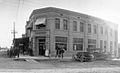
Downtown Imperial Business Center (at the intersection of what is now Imperial Avenue and Barioni Blvd.) circa 1913
-

Mid-Winter Fair in Imperial


See also
 In Spanish: Imperial (California) para niños
