Independence, Virginia facts for kids
Quick facts for kids
Independence, Virginia
|
|
|---|---|

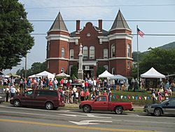
July 4th celebrations at the Grayson County Courthouse, 2006
|
|

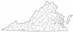
Location of Independence, Virginia
|
|
| Country | United States |
| State | Virginia |
| County | Grayson |
| Area | |
| • Total | 2.35 sq mi (6.08 km2) |
| • Land | 2.34 sq mi (6.07 km2) |
| • Water | 0.00 sq mi (0.01 km2) |
| Elevation | 2,680 ft (820 m) |
| Population
(2010)
|
|
| • Total | 947 |
| • Estimate
(2019)
|
892 |
| • Density | 380.71/sq mi (147.00/km2) |
| Time zone | UTC-5 (Eastern (EST)) |
| • Summer (DST) | UTC-4 (EDT) |
| ZIP code |
24348
|
| Area code(s) | 276 |
| FIPS code | 51-39528 |
| GNIS feature ID | 1498495 |
Independence is a town in Grayson County, Virginia, United States. The population was 947 at the 2010 census. It is the county seat of Grayson County.
Site of the annual July 4 town celebration at the 1908 courthouse, the festival features bluegrass music, dance, food, crafts and a pony sale. The courthouse is also the location of the autumn Mountain Foliage Festival with a parade, crafts, arts, music and the Grand Privy Race, during which contestants race outhouses on Main Street.
History
The Brookside Farm and Mill and Grayson County Courthouse are listed on the National Register of Historic Places.
Geography
Independence is located at 36°37′22″N 81°9′6″W / 36.62278°N 81.15167°W (36.622906, -81.151735).
According to the United States Census Bureau, the town has a total area of 2.3 square miles (6.1 km²), all land.
Grayson County has a particularly mountainous terrain, specifically in the western half. Grayson county contains 4 of Virginia's 5 highest peaks including Pine Mountain and Whitetop Mountain.
Demographics
| Historical population | |||
|---|---|---|---|
| Census | Pop. | %± | |
| 1940 | 429 | — | |
| 1950 | 486 | 13.3% | |
| 1960 | 679 | 39.7% | |
| 1970 | 673 | −0.9% | |
| 1980 | 1,112 | 65.2% | |
| 1990 | 988 | −11.2% | |
| 2000 | 971 | −1.7% | |
| 2010 | 947 | −2.5% | |
| 2019 (est.) | 892 | −5.8% | |
| U.S. Decennial Census | |||
At the 2000 census there were 971 people, 426 households, and 226 families in the town. The population density was 415.1 people per square mile (160.2/km²). There were 497 housing units at an average density of 212.5 per square mile (82.0/km²). The racial makeup of the town was 90.73% White, 6.80% African American, 1.24% from other races, and 1.24% from two or more races. Hispanic or Latino of any race were 2.68%.
Of the 426 households 19.2% had children under the age of 18 living with them, 39.9% were married couples living together, 8.2% had a female householder with no husband present, and 46.9% were non-families. 44.6% of households were one person and 27.5% were one person aged 65 or older. The average household size was 1.98 and the average family size was 2.73.
The age distribution was 14.4% under the age of 18, 7.1% from 18 to 24, 21.1% from 25 to 44, 22.7% from 45 to 64, and 34.7% 65 or older. The median age was 51 years. For every 100 females there were 81.5 males. For every 100 females age 18 and over, there were 82.2 males.
The median household income was $18,264 and the median family income was $30,441. Males had a median income of $21,058 versus $16,705 for females. The per capita income for the town was $16,137. About 10.5% of families and 19.5% of the population were below the poverty line, including 29.7% of those under age 18 and 16.2% of those age 65 or over.
Climate
The climate in this area has mild differences between highs and lows, and there is adequate rainfall year-round. According to the Köppen Climate Classification system, Independence has a marine west coast climate, abbreviated "Cfb" on climate maps.
Notable person
- Wade Ward, old-time musician
See also
 In Spanish: Independence (Virginia) para niños

