Indiana Harbor and Ship Canal facts for kids
Quick facts for kids Indiana Harbor Canal |
|
|---|---|

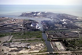
Aerial view of Indiana Harbor and Ship Canal
|
|
| Location | East Chicago, Indiana |
| Country | United States |
| Coordinates | 41°40′06″N 87°26′25″W / 41.6684°N 87.4402°W |
| Specifications | |
| Length | 6.75 miles (10.86 km) |
| Locks | None |
| Status | Open |
| Geography | |
| Start point | Lake Michigan |
| End point | Grand Calumet River |
| Branch(es) | Grand Calumet River Branch Lake George Branch |
The Indiana Harbor and Ship Canal is an artificial waterway on the southwest shore of Lake Michigan, in East Chicago, Indiana, which connects the Grand Calumet River to Lake Michigan. It consists of two branch canals, the 1.25 mile (2 km) Lake George Branch and the 2 mile (3 km) long Grand Calumet River Branch which join to form the main Indiana Harbor Canal.
The canal also functions as a harbor (Indiana Harbor). The outer harbor is sheltered by two bulkheads marked by lights including the Indiana Harbor East Breakwater Light. Ships enter the outer harbor from the north. The inner harbor consists of the canal itself. The entrance to the outer harbor lies near Indiana Shoals, which extend up to 5 miles offshore, where water depths are as shallow as 15 feet.
In 2002, Indiana Harbor was the 45th busiest harbor in the United States, handling almost 13,300,000 short tons (12,000,000 metric tons) of cargo. Foreign trade accounted for only 500,000 short tons (450,000 metric tons) of that. Indiana Harbor is maintained by the Chicago District of the U.S. Army Corps of Engineers, as authorized by the Rivers and Harbors Act of 1913.
History
The canal and harbor were built over several years beginning in 1901. On March 26, 1901, Inland Steel Company accepted an offer from the Lake Michigan Land Company of 50 acres (200,000 m²) (20 hectares) of free land along with a promise of construction of a harbor and railroad. For its part, Inland Steel agreed to construct a steel mill there that would cost no less than one million dollars. The shortline railway connecting this area to other rail lines is still known as the Indiana Harbor Belt Railroad.
Marktown, Clayton Mark's planned worker community, is located at Indiana Harbor.
Economy
Manufacturing
Indiana Harbor and Canal lies in a heavily industrial area which includes ArcelorMittal Steel's two Indiana Harbor Works facilities. On the west side of the canal is the former Youngstown - J & L - LTV Steel - ISG steel mill. On the east side of the canal is the other Indiana Harbor Works, once known as Inland Steel Company, then Ispat Inland. BP's refinery in Whiting is nearby.
The harbor allows transport of iron ore (taconite pellets) and limestone to the steel mills from the mines and quarries of the upper Midwest through the Great Lakes. Other commodities include coke, gypsum, steel, cement and concrete, petroleum products, and miscellaneous bulk products.
The harbor is ranked first in tonnage among the 25 Federal commercial harbors on Lake Michigan, and second in tonnage of the 55 Federal commercial harbors on the Great Lakes.

