
Indio, California facts for kids
Quick facts for kids
Indio
|
|
|---|---|
| City of Indio | |

|
|
| Nickname(s):
The City of Festivals
|
|
| Motto(s):
"The Place to Be"
|
|

Location of Indio in Riverside County, California
|
|

Indio
Location in southern California

Indio
Location in California

Indio
Location in the United States
|
|
| Country | United States |
| State | California |
| County | Riverside |
| Incorporated | May 16, 1930 |
| Government | |
| • Type | City Council–City Manager |
| Area | |
| • Total | 33.23 sq mi (86.08 km2) |
| • Land | 33.23 sq mi (86.06 km2) |
| • Water | 0.01 sq mi (0.02 km2) 0.03% |
| Elevation | −13 ft (−4 m) |
| Population
(2020)
|
|
| • Total | 89,137 |
| • Rank | 90th in California |
| • Density | 2,682.4/sq mi (1,035.51/km2) |
| Time zone | UTC−8 (Pacific) |
| • Summer (DST) | UTC−7 (PDT) |
| ZIP Codes |
92201–92203
|
| Area code(s) | 442/760 |
| FIPS code | 06-36448 |
| GNIS feature IDs | 1652727, 2410101 |
Indio (Spanish for "Indian") is a city in Riverside County, California, United States, in the Coachella Valley of Southern California's Colorado Desert region. It lies 23 miles (37 km) east of Palm Springs, 75 miles (121 km) east of Riverside, 127 miles (204 km) east of Los Angeles, 148 miles (238 km) northeast of San Diego, and 250 miles (402 km) west of Phoenix.
The population was 89,137 in the 2020 United States Census, up from 76,036 at the 2010 census, an increase of 17%. Indio is the most populous city in the Coachella Valley, and was formerly referred to as the Hub of the Valley after a Chamber of Commerce slogan used in the 1970s. It was later nicknamed the City of Festivals, a reference to the numerous cultural events held in the city, most notably the Coachella Valley Music and Arts Festival.
Contents
History
Railroad line construction east out of Los Angeles began in 1873. Trains were operated to Colton on July 16, 1875, and to Indio (then Indian Wells) on May 29, 1876. Moving on eastward from Indio, the railroad reached the west bank of the Colorado River opposite Yuma on May 23, 1877 (a village known as Arizona City prior to 1873). There was delay in getting military authority to lay tracks across the Yuma Indian reservation, and it was September that year before the bridge was completed so trains could operate into Yuma. The Southern Pacific Railroad was to have joined those of the Texas & Pacific, one of several railroads then holding, or seeking, federal authority to build lines from various sections of the country west to the Pacific Coast. But the rail-head of the T & P was at a standstill far off in Texas, so Southern Pacific continued building eastward. (A Historical Sketch of the SOUTHERN PACIFIC 1869-1944 by Erle Heath Editor, The Southern Pacific "Bulletin", www.cprr.org/Museum/SP_1869-1944/).
The City of Indio came about because of the need of a halfway point for the Southern Pacific Railroad between Yuma, Arizona and Los Angeles. The engines needed to be re-filled with water. At first, the-would-be city was called Indian Wells, but because of so many other areas already called that, Indio – after a Spanish variation of the word "Indian" – was chosen. After the railroad's arrival in 1876, Indio really started to grow. The first permanent building was the craftsman style Southern Pacific Depot station and hotel. Southern Pacific tried to make life as comfortable as it could for their workers in order to keep them from leaving such a difficult area to live in at the time. It was at the center of all social life in the desert with a fancy dining room and hosting dances on Friday nights.
While Indio started as a railroad town, it soon became agricultural. Onions, cotton, grapes, citrus and dates thrived in the arid climate due to the ingenuity of farmers finding various means of attaining water; first through artesian wells and later through the valley’s branch of the All-American Canal. However, water also was a major problem for Indio and the city was flooded several times until the storm water canals were created throughout the Coachella Valley.
Businessmen and women found this last frontier land of the continental United States as an ideal place to start fresh. Dr. Harry Smiley and his wife Nell were early residents and stayed in Indio after their car broke down on the way to Los Angeles and became people of influence and helped shape the area. A.G. Tingman was an early storeowner and first Postmaster of Indio, but also well known for taking advantage of miners as they headed to the mountains, selling at rather high prices. Later Dr. June Robertson McCarroll became a leading philanthropist as well as successful doctor in Indio. She was responsible along with the Indio Woman’s Club for pressing California into adopting the placing of white lines down the streets after she nearly got hit one too many times by passing vehicles. But even though these early founders of the city are considered pioneers, they still partook in the lifestyles of their friends living in such areas as Los Angeles. Indio established itself quickly and kept up with all the trends as they were brought in by the railroads.
By the turn of the 20th century, Indio was already more than a fading railroad town. Schools were built, the La Casita hospital provided medical services, and families established roots. This was the growth of a city, not just a railroad town.
By 1920, about one to two thousand year round residents lived in Indio, while it can double to 2,500 to 5,000 during the winter months and was advertised as a health resort for senior citizens and those with respiratory diseases and ailments in the rest of the 20th century.
Indio also served as the home of the USDA’s Date Station, a place where leading scientific research was taking place on the fruit that would become a major part of the culture of Indio. The station started in 1907 and was responsible for the ability of local farmers to better understand this unique crop and make the Coachella Valley a leader in American date crops. This also created a tie to the Middle East that led to the theme for the County Fair with the Middle Eastern flair.
Coachella and Thermal were soon larger cities than Indio, but Indio remained the “Hub of the Valley,” as it was called. With the burning of the majority of Thermal and the decline of Coachella, Indio grew again. By 1930 Indio was a thriving area and incorporated. On September 6, 1930, storekeeper Fred Kohler received the first business license in Indio.
Indio was also aided by the visiting soldiers from Patton’s training grounds in Chiriaco Summit located 30 miles to the east. However, Indio saw another decline as the valley’s population begin to move west towards newer cities such as Palm Desert. However, now there is a reversal in this trend and the eastern section of the valley is poised to once again become the center of the Coachella Valley.
The city had significant unemployment rates (in some cases over 20 percent) in the late 20th century and from the recession in the late 2000s. The rapid population growth fueled the city's present need for employment opportunities.
Geography
Indio is located at 33°43′12″N 116°13′55″W / 33.72000°N 116.23194°W (33.719871, -116.231889). According to the United States Census Bureau, the city has a total area of 75.6 square kilometers (29 sq mi), 99.97% of which is land and 0.03% is water.
The telephone area code is 760. The city's ZIP codes are 92201 and 92203 north of Interstate 10. About 3 miles (5 km) north and east of Indio is the San Andreas Fault, a major tectonic plate boundary of the Pacific and North American plates.
Indio is home of Riverside County's eastern administration offices. Palm Springs had more people from 1955 to 1992, when the US census announced Indio surpassed Palm Springs and that title was returned to them. The official elevation of Indio is below sea level; the city hall is 14 feet (4 m) below sea level, as the Eastern half of the Coachella valley drops as low as 150 feet (50 m) below sea level (the lake shore of the Salton Sea is 15 miles (24 km) South of Indio).
Climate
The climate of the Coachella Valley is influenced by the surrounding geography. High mountain ranges on three sides contribute to its unique and year-round warm climate, with some of warmest winters west of the Rocky Mountains. Indio has a warm winter/hot summer climate (Köppen: BWh): Its average annual high temperature is 89.5 °F (31.9 °C) and average annual low is 62.1 °F (16.7 °C) but summer highs above 108 °F (42 °C) are common and sometimes exceed 120 °F (49 °C), while summer night lows often stay above 82 °F (28 °C). Winters are warm with daytime highs often between 68–86 °F (20–30 °C). Under 4 inches (100 mm) of annual precipitation are average, with over 348 days of sunshine per year. The hottest temperature ever recorded there was 125 °F (52 °C) on July 6, 1905. The mean annual temperature is 75.8 °F (24.3 °C).
| Climate data for Indio, California | |||||||||||||
|---|---|---|---|---|---|---|---|---|---|---|---|---|---|
| Month | Jan | Feb | Mar | Apr | May | Jun | Jul | Aug | Sep | Oct | Nov | Dec | Year |
| Record high °F (°C) | 97 (36) |
100 (38) |
104 (40) |
110 (43) |
121 (49) |
123 (51) |
125 (52) |
121 (49) |
122 (50) |
115 (46) |
101 (38) |
96 (36) |
125 (52) |
| Average high °F (°C) | 71.9 (22.2) |
75.3 (24.1) |
81.3 (27.4) |
87.5 (30.8) |
95.7 (35.4) |
103.1 (39.5) |
107.3 (41.8) |
106.6 (41.4) |
102.0 (38.9) |
91.9 (33.3) |
79.6 (26.4) |
71.0 (21.7) |
89.5 (31.9) |
| Average low °F (°C) | 44.6 (7.0) |
48.0 (8.9) |
54.8 (12.7) |
60.7 (15.9) |
67.7 (19.8) |
74.2 (23.4) |
80.3 (26.8) |
80.3 (26.8) |
74.0 (23.3) |
63.7 (17.6) |
51.8 (11.0) |
44.2 (6.8) |
62.1 (16.7) |
| Record low °F (°C) | 13 (−11) |
20 (−7) |
25 (−4) |
33 (1) |
38 (3) |
45 (7) |
59 (15) |
56 (13) |
46 (8) |
31 (−1) |
23 (−5) |
17 (−8) |
13 (−11) |
| Average precipitation inches (mm) | 0.56 (14) |
0.64 (16) |
0.43 (11) |
0.05 (1.3) |
0.07 (1.8) |
0.01 (0.25) |
0.04 (1.0) |
0.54 (14) |
0.04 (1.0) |
0.26 (6.6) |
0.18 (4.6) |
0.62 (16) |
3.44 (87) |
| Source: NOAA (normals 1981–2010) | |||||||||||||
Nature and wildlife
Indio is in the Colorado Desert region of the Sonoran Desert. It is adjacent to the geologic Salton Sink and within the site of historic Lake Cahuilla of the Lower Colorado River Valley. Indio is an official National Bird Sanctuary, because of the seasonal bird migration flight routes that cross the town en route to the Salton Sea.
- Geography of the Colorado Desert
- Fauna of the Colorado Desert
- Sonoran Desert wildflowers
Demographics
| Historical population | |||
|---|---|---|---|
| Census | Pop. | %± | |
| 1940 | 2,296 | — | |
| 1950 | 5,300 | 130.8% | |
| 1960 | 9,745 | 83.9% | |
| 1970 | 14,459 | 48.4% | |
| 1980 | 21,611 | 49.5% | |
| 1990 | 36,793 | 70.3% | |
| 2000 | 49,116 | 33.5% | |
| 2010 | 76,036 | 54.8% | |
| 2020 | 89,137 | 17.2% | |
| U.S. Decennial Census | |||
2010
The 2010 United States Census reported that Indio had a population of 76,036. The population density was 2,604.9 people per square mile (1,005.8/km2). The racial makeup of Indio was 46,735 (61.5%) White (27.0% Non-Hispanic White), 1,805 (2.4%) African American, 741 (1.0%) Native American, 1,693 (2.2%) Asian, 55 (0.1%) Pacific Islander, 22,394 (29.5%) from other races, and 2,613 (3.4%) from two or more races. Hispanic or Latino of any race were 51,540 persons (67.8%).
There were 23,378 households, out of which 10,522 (45.0%) had children under the age of 18 living in them, 13,149 (56.2%) were opposite-sex married couples living together, 3,578 (15.3%) had a female householder with no husband present, 1,512 (6.5%) had a male householder with no wife present. There were 1,654 (7.1%) unmarried opposite-sex partnerships, and 232 (1.0%) same-sex married couples or partnerships; 3,859 households (16.5%) were made up of individuals, and 1,777 (7.6%) had someone living alone who was 65 years of age or older. The average household size was 3.21. There were 18,239 families (78.0% of all households); the average family size was 3.60.
The population was spread out, with 22,879 people (30.1%) under the age of 18, 7,247 people (9.5%) aged 18 to 24, 20,705 people (27.2%) aged 25 to 44, 15,793 people (20.8%) aged 45 to 64, and 9,412 people (12.4%) who were 65 years of age or older. The median age was 32.2 years. For every 100 females, there were 97.3 males. For every 100 females age 18 and over, there were 94.5 males.
There were 28,971 housing units at an average density of 992.5 per square mile (383.2/km2), of which 15,274 (65.3%) were owner-occupied, and 8,104 (34.7%) were occupied by renters. The homeowner vacancy rate was 5.0%; the rental vacancy rate was 12.5%, while 46,780 people (61.5% of the population) lived in owner-occupied housing units and 28,307 people (37.2%) lived in rental housing units.
During 2009–2013, Indio had a median household income of $50,068, with 21.9% of the population living below the federal poverty line.
2000
As of the census of 2000, there were 49,116 people, 13,871 households, and 11,069 families residing in the city. The population density was 1,840.3 people per square mile (710.5/km2). There were 16,909 housing units at an average density of 633.6 per square mile (244.6/km2). The racial makeup of the city was 44.4% White, 2.8% Black, 1.0% Native American, 1.5% Asian American, 0.1% Pacific Islander, 42.0% from other races, and 3.9% from two or more races. 65.7% of the population were Hispanic or Latino of any race.
There were 13,871 households, out of which 48.2% had children under the age of 18 living with them, 55.9% were married couples living together, 16.7% had a female householder with no husband present, and 20.2% were non-families. Of all households 16.0% were made up of individuals, and 7.0% had someone living alone who was 65 years of age or older. The average household size was 3.5 and the average family size was 3.9.
In the city, the population was spread out, with 35.3% under the age of 18, 11.1% from 18 to 24, 29.4% from 25 to 44, 15.2% from 45 to 64, and 9.1% who were 65 years of age or older. The median age was 27 years. For every 100 females, there were 101.2 males. For every 100 females age 18 and over, there were 98.8 males.
The median income for a household in the city was $34,624, and the median income for a family was $35,564. Males had a median income of $25,651 versus $21,093 for females. The per capita income for the city was $13,525. About 16.8% of families and 21.5% of the population were below the poverty line, including 28.2% of those under age 18 and 12.0% of those age 65 or over.
Population growth
From 1984 to 2008, Indio grew many times its previous size. Indio handles unprecedented growth for being a select area of choice for thousands of new residents per year. In 2018, Indio was ranked the 30th fastest-growing city in America and 8th fastest-growing city in California.
The 2010 United States Census recorded the city's population to be about 76,000 residents, but it did not include the addition of seasonal residents. According to the Demographic Research Unit (DRU) of the California Department of Finance, the provisional population estimate for the City of Indio as of January 1, 2019, was 89,406.
City leaders and other locals are expanding city public services, including recreation activities, commercial retail centers and industrial complexes.
Arts and culture
Annual events
Because of the numerous festivals and special events held annually in Indio, the Chamber of Commerce deemed Indio's official nickname to be: "The City of Festivals." The Date Festival/County Fairgrounds is a facility that hosts various events year round such as music concerts, 4x4 monster truck rallies, rodeos or other special events.
Two major annual festivals are the National Date Festival and the Indio International Tamale Festival. Riverside County Fair and National Date Festival is held each February at the Riverside County Fairgrounds, located on Highway 111 in the heart of Indio. Since 1947, this festival has celebrated the date fruit crop of the Coachella Valley. The Tamale Festival is held each December on the streets of Old Town Indio and holds one Guinness World Record as the largest tamale festival (120,000 in attendance, Dec. 2-3, 2000) and once held the record for the world's largest tamale, [over 1 foot (0.3 m) in diameter and 40 feet (12.2 m) in length], created by Chef John Sedlar but that record has since been surpassed by another.
In 1993, Paul Tollett, president of Goldenvoice, booked a Pearl Jam concert at the Empire Polo Club in Indio and six years later the Coachella Valley Music and Arts Festival was born. Since 2001, Coachella has been an annual event that has brought notable music acts to the desert, including: Prince, Paul McCartney, Kanye West, Radiohead, Dr. Dre, Snoop Dogg, Pixies, The Cure, The White Stripes, Jay-Z, Tool, Beastie Boys, Red Hot Chili Peppers, Jane's Addiction, Roger Waters and several others. Coachella extended the festival to three days in 2007 and in 2010, organizers did away with single-day tickets, offering instead three-day passes. Whatever changes the Coachella festival makes, it continues to draw large amounts of concertgoers to Indio and the Empire Polo Club—a venue that Rolling Stone said possessed a "lush beauty... that made the desert seem very far away."
In May 2007, Goldenvoice, promoters of Coachella, started Stagecoach, a two-day country music festival held the weekend following the Coachella. Performers have included George Strait, Kenny Chesney, the Eagles, Sugarland, Taylor Swift, Carrie Underwood and Kid Rock.
In 2013, OC Weekly's Dave Barton described the arts scene in Indio with "seems to consist of Johnny Cash tributes, chalk art, camel and ostrich races, and Neil Simon revivals."
On April 15, 2016 it was reported that Goldenvoice was trying to bring together The Rolling Stones, The Who, Paul McCartney, Bob Dylan, Roger Waters, and Neil Young for a 3-day mega concert known as Desert Trip to take place some time in 7–9 October 2016. It would take place at the same venue as the Coachella Music Festival.
Indio is also the site of the annual Southwest Arts Festival, the Cabazon Indian National Pow Wow, the Palm Springs Kennel Club's Annual Dog Show and Rhythm, Wine and Brews Festival at the Empire Polo Club, Heritage Festival at the Coachella Valley History Museum and the Family Motor Coach Association's Annual Western Region RV Rally at the Fairgrounds.
The Fantasy Springs Resort Casino is located in Indio.
Points of interest
The Coachella Valley History Museum [1] on Miles Avenue in Indio, has a two-acre campus, which currently includes the Smiley-Tyler House, built in 1926, the 1909 Schoolhouse, and the Date Museum dedicated to the history and development of the fruit (the only date museum in the world), plus gardens and archives preserving historical artefacts of the Coachella Valley.
Indio Hills Palms, state park property, are native California fan palms that thrive in many locations but rarely in such numbers as in the canyons of the Indio Hills. Here, along a line where the San Andreas fault captures groundwater that nurtures the palms, is a wild parkland which is part of the adjacent Coachella Valley Preserve. The park contains some fine native palm groves that include Indian, Hidden, Pushawalla, Biskra, Macomber and Horseshoe palms. The nearest palm groves are relatively easy to reach from the trailhead and parking area 4 miles (6 km) north of Indio. There are currently no marked access roads to the property.
Indio's old town historic mural program
In the fall of 1996 the Indio Chamber of Commerce formed a committee to develop a Historic Mural Project to help revitalize the local economy at the time of the statewide economic recession. Several communities have benefited from similar programs, such as Chemainus, Canada; El Paso, Texas; and Eureka, Bishop, Needles, & 29 Palms in California, as well the famous Chicano Park mural to commemorate Hispanic-American life in Barrio Logan, San Diego in the late 1970s.
It began with a suggestion to start a mural project first brought to the city by David Hernandez, a former Indio city council member, after he visited Chemainus. Very little happened with this concept until 1996, when the Riverside County National Date Festival's executive director Bruce Latta and commissioned artist Bill Weber of San Francisco to paint a mural of the Taj Mahal on the Taj Mahal (Garden of Allah) building at the fairgrounds. At the same time, local businessman Bruce Clark, who was instrumental in promoting Historic U.S. Route 99 (Indio Blvd.) to its former status as the Main Street of California. He maintains a website on Historic Route 99 (http://www.indiocaroute99.com/component/option,com_frontpage/Itemid,1/). He brought the mural idea forward again, after seeing the success of a similar local program in 29 Palms. When Clark presented the idea to the chamber board of directors the idea was immediately recognized as something that could help the city's economy by encouraging tourism. Indio now has ten murals about the city on the sides of various buildings in old town or a water reservoir tank on Monroe Street.
Pop culture
Indio has appeared in movies, television and music.
Indio and surrounding areas was in the 1980 Mexican movie Johnny Chicano about Mexican tourists meet up a local Mexican-American.
The city's namesake appeared on a circus poster in a fast food joint scene of the 1990 comedy movie. A little league record-holding batter from Indio was one of the talented youth athletes on the intro of sports comedy movie Jerry Maguire.
Indio was also the site of an episode of Monster Garage in which a Ford Mustang convertible was converted into a lawn mower. Huell Howser's state travel show California Gold stopped by "Old Town Indio" to report on the city's older dwellings had swamp coolers for permanent residents to stay cool in the summer.
In addition, Visiting. . . with Huell Howser came to the 1997 Indio International Tamale Festival (episode #529) where he spent time eating tamales and interviewing various vendors and visitors at the Festival. He returned to the festival the next couple of years to serve as a judge in the Best Tamale Contest.
The Jackie & Bender morning show's Harry Potter E! True Hollywood Story parody mentions Indio as the town that Harry Potter is arrested in during a Meth lab bust.
Indio was a location for film, The Beast with a Million Eyes, starring Dona Cole and Chester Conklin.
An episode of the animated The Rocky and Bullwinkle Show titled The Ruby Yacht of Omar Khayyam announces the upcoming second installment of the episode as Rimsky & Korsakov Go to Palm Springs, or Song of Indio.
Indio was mentioned 3 times on the Phil Hendrie Show radio comedy, once about the bus station, a car wash business and a grocery store that the host made jokes about his travels in the city.
ABC's Scoundrels is set in Indio and other Desert Cities' however, it is being filmed in Albuquerque, New Mexico.
The Big 4 of thrash metal, Metallica, Slayer, Megadeth, and Anthrax played the first U.S. Big 4 show at the Empire Polo Grounds in Indio.
Comedian Peter Grosz mentioned Indio as the setting for his fictional story in the May 14, 2016 "Bluff the Listener" section of the game show Wait Wait... Don't Tell Me! on National Public Radio.
"Indio" is the opening track on the 2012 album 'Coyote' by Matt Mays. It makes reference to "some of that old fashioned California sin".
"Indio" was the name chosen by Canadian folk singer Gordon Peterson's environmental project album, "Big Harvest" (1989), featuring the hit, (big) Hard Sun, which was also covered by Pearl Jam's Eddie Vedder. The name "Indio" came to Peterson in the California desert when he was driving to Mexico, and Indio was the last town he traveled through before crossing the border.
Miscellaneous
The annual National Date Festival's main attraction is the nightly musical pageant Arabian Nights in an open-air amphitheater. After the National Date Festival, a "SuperFiesta del Sinaloa" follows to honor Indio's historic ties with the Mexican state of Sinaloa, a large source of local immigration. A great amount of immigrants also come from the Mexican state of Michoacán, especially from the municipalities of Jiquilpan, Sahuayo and even from small communities such as La Lagunita and Paredones.
The Landmark Golf Club opened in 1998 and had the Skins Game for four years. It is now known as Terra Lago and includes the residential community of Terra Lago. There are golf courses in Indio: such as the Plantation, Heritage Palms, Sun City Shadow Hills, Indian Springs and Indian Palms. The Indio (municipal) Golf Club is the second longest par-3 executive course in the USA, it is the only night lighted course in the Coachella Valley and is open until 10:00 PM.
It has two world-famous polo clubs: Empire and Eldorado on the city's southwestern end that hold annual polo and special events. The Prince of Wales and Sarah, Duchess of York were seen in the polo clubs.
The local electricity provider, Imperial Irrigation District rates are 30% less on their electric bills than neighbors to the west, under Southern California Edison. In 2001, Forbes magazine designated part of the Valley that included Indio west of Monroe Street (and nearby La Quinta, Bermuda Dunes and Indian Wells, all the way to Gene Autry Trail in Palm Springs) as one of America's wealthiest areas.
In 1999, Larry Fortensky, one of actress Elizabeth Taylor's husbands, was arrested for drug possession near Indio. In the following year (2000), actor Robert Downey Jr. attended trial for drug possession (he was in Palm Springs) in the Larson Justice Center county court house with media coverage.
Sister cities
 Mexicali – International Sister Cities program.
Also the city had a chamber of commerce relationship with the Mexican state of Sinaloa.
Indio had city-to-city economic exchange programs with San Luis Rio Colorado, Sonora, Mexico in the Sister Cities International (SCI) program. There are similar inter-city exchange agreements with Lynwood, California; Farmington, Minnesota; and American Fork, Utah in the U.S., and officials from the Vancouver 2010 Winter Olympic Games visited the 2010 National Date Festival to promote the Vancouver, British Columbia, Canada area.
Economy
Two major contributions to the local economy are year-round agriculture and tourism, although the majority of tourist activity is seasonal, between October and May.
Agriculture
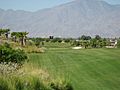
.jpg)
Indio has been one of Southern California's most important agricultural regions, once responsible for a large percentage of the nation's date crop; however, increasing residential and recreational development, the date groves are now more limited to the south and southeast of Indio. Even the grove of date palm trees at the Riverside County Fair and national Date Festival grounds have been removed by the county.
Travelers from around the world still can stop by Shields Date Gardens, a date grower that maintains a large retail store along State Highway 111. There are citrus groves and vegetable fields surrounding the city limits, but rapid development of new housing tracts and golf courses in the "East Valley" in the 1990s and 2000s has displaced most of the agricultural space.
Employment and job growth
In recent years, Indio served as a magnet of job opportunities for immigrants and newcomers from parts of California and across the nation. Job fields such as agriculture, construction, hospitality (hotels and resorts), maintenance, and retail and housekeeping are highly needed in the area.
Construction and government are one of the largest employment sectors in Indio, with a higher proportion of workers in these industries in Indio than the rest of the Coachella Valley.
In addition to construction and government, a recent 2019 study revealed that the top five employment industries in Indio are educational services, entertainment services, wholesale/retail, agriculture/mining/construction, and waste services. Between 2007 and 2015, the percentage of retail trade jobs in Indio increased by 4.4 percent and the percentage of education jobs increased from 15.2 to 20.5 percent.
As the second seat of government for Riverside County, California, Indio has many county offices and employs more than a thousand county employees. The California Superior Court's Larson Justice Center, Riverside County's Law Library and District Attorney's office, numerous law firms along Highway 111, and the California Desert Trial Academy (CDTA) College of Law (the only law school in Riverside County), located at 45290 Fargo Street, have made Downtown Indio the center for law and legal studies in the Coachella Valley.
The average salary for a job in Indio increased from $28,224 in 2003 to $35,532 in 2015. The City of Indio is constantly expanding to see the number of jobs and average salaries rise. It is currently in the process of a 2040 general plan to increase the number of developments in Indio. For example, the city opened a 120-room Fairfield Inn and Suites in February 2019 and broke ground on a 93-room Hampton Inn and Suites that is expected to open January 2020. A new movie theater and the continual development of retail stores at the Indio Towne Center, The Showcase at Indio, and The Palms shopping centers is also sure to create an abundance of jobs.
Light industry is not new to Indio. Between the 1960s and the early 1980s, the Bank of America-owned Giannini Research Institute, Kaiser Inc. and Cabazon Firearms had contracts with both NASA and the US Armed Forces that produced ammunition, computer parts, moon rover parts for the Apollo landing program, and train engines for the Southern Pacific Railroad. Indio sought more corporate businesses and office professions, including fruit packing and shipping firms. Locally based United States Filter Corporation, Guy Evans Inc., Dimare Fruit Co., West Coast Turf and Japanese-owned Sun World Inc.; and move-in companies such as Borden, Coca-Cola, Ernie Ball, Ernst and Young, Ferguson, Fulton Distributors, Guthy-Renker, Pulte Homes, Sunrise Company, SunScape Tech and Tala Industries choose Indio for the location of transport routes, low economic costs, and growth potential.
Indio is home to Buzz Box Premium Cocktails, Ring Power Corporation, Triangle Distributing Company (formerly Heimark), The Forager Project, and Purus International. Other companies in Indio include Pepsi Cola Distributing, RDO Equipment, Sepulveda Building Materials, Fortun Foods, Arctic Glacier, A.C. Houston Lumber Company, and Commercial Lighting Industry.
Top employers
According to the city's 2020 Comprehensive Annual Financial Report, the top employers in the city are:
| # | Employer | # of Employees |
|---|---|---|
| 1 | Desert Sands Unified School District | 2,455 |
| 2 | County of Riverside | 1,135 |
| 3 | Fantasy Springs Resort Casino | 1,083 |
| 4 | John F. Kennedy Memorial Hospital | 690 |
| 5 | Walmart Supercenter | 356 |
| 6 | City of Indio | 248 |
| 7 | Ralphs | 169 |
| 8 | Riverside County Superior Court | 166 |
| 9 | Indio Nursing and Rehabilitation Center | 161 |
| 10 | Cardenas Markets | 151 |
Native American gaming

Two Native American owned casinos in and near Indio are the Fantasy Springs Resort Casino, owned by the Cabazon Band of Mission Indians, and the Spotlight 29 Casino, owned by the Twenty-Nine Palms Band of Mission Indians. Spotlight 29 formerly was "Trump 29" when it was partly owned by then-businessman Donald Trump for a brief period of time in the 2000s.
Education
Indio is served by two public school districts: Desert Sands Unified and on the city's southeastern corner, Coachella Valley Unified. Desert Sands' headquarters is located in La Quinta.
Indio's six elementary and two middle schools are highly rated under the California Distinguished Schools program. Because of Indio's growing population and above-average number of young people with families, the two school districts are expanding, with plans on building more schools, along with remodeling the older ones with new buildings and designs.
Schools in or near Indio:
Desert Sands Unified
- Elementary (grades K–5): Carrillo Ranch, Dr. Reynaldo J. Carreon Jr. Academy, Amelia Earhart (International studies), John Adams (STEM school) near Benjamin Franklin in La Quinta, Richard Oliphant, Herbert Hoover, Andrew Jackson, Lyndon B. Johnson, John F. Kennedy, James Madison, James Monroe (in Bermuda Dunes), Theodore Roosevelt, Martin Van Buren, and Horizon Elementary (independent studies) in La Quinta
- Middle/junior high schools (grades 6–8): Colonel Mitchell Paige Middle School (in La Quinta), La Quinta Middle, Desert Ridge Academy; Thomas Jefferson; Indio Middle School (Charter); John Glenn Middle School of International Studies (California Distinguished School); and Horizon Middle (independent studies) in La Quinta
- High schools (grades 9–12): Indio High; La Quinta High in La Quinta; Shadow Hills; Amistad High, a continuation high school in former site of Woodrow Wilson Middle School; and Horizon High (independent studies) in La Quinta
- Adult school: Courses include: GED Test preparation, ESL Beg/Int/Adv classes, Citizenship classes, a RossettaStone Language lab, and more.
- Special studies: Eisenhower Community Education Center.
Coachella Valley Unified schools
- Elementary (grades K–6): Mountain Vista Elementary
- Middle/junior high schools (grades 7–8): Cahuilla Desert Academy
- High schools (grades 9–12): Coachella Valley High and Desert Mirage High School, both in Thermal
Private schools
Grace Academy (K–8), Indio Christian Center (1–12), River Springs Charter School (K–12), Our Lady of Perpetual Help (PK–8), Trinity Lutheran Child Development Center (PK, K) and Christian School of the Desert (PK–12), located in nearby Bermuda Dunes
Higher education

College of the Desert, commonly referred to by its initials (C.O.D), is the Coachella Valley's community college. C.O.D opened a campus facility in 2002 in the Riverside County Employment Developmental Center located on Monroe Street. And their Indio campus on Oasis street. They expanded their classes to an "East Valley" educational center in Mecca.
Riverside County has a Regional Occupational Program facility in Indio that provides vocational educational courses in the Coachella Valley's job market.
The California Desert Trial Academy College of Law was approved by the California State Bar as an unaccredited fixed facility law school in Indio and is currently holding classes in the County Law Library in Indio. Meanwhile, plans are moving forward on the school constructing its own campus buildings in downtown Indio.
Infrastructure
Transportation
Bermuda Dunes Airport (FAA designator: UDD) is on the north-western border of Indio, along I-10 just west of Jefferson Street. It has a 5,000-foot (1,500 m) runway and serves small private planes, air carriers and commuter jets. The Jacqueline Cochran Regional Airport in Thermal just a few minutes from Indio, is named for the famous 1920s pilot and Indio resident and used for cargo planes to ship agricultural products, also on the four-lane California State Route 86 expressway or the "NAFTA highway" (in reference to the North American Free Trade Agreement) for international traffic. The closest airport with regularly-scheduled commercial passenger service is Palm Springs International Airport, about 20 miles (32 km) away.

Greyhound and Amtrak Thruway Motorcoach intercity passenger buses stop at Indio station with regular services to stops in Southern California, Arizona, and the Mexican border. The city is served by the local bus line SunLine Transit Agency ("SunBus"), which services much of the Coachella Valley. The Amtrak rail station is expected to be reactivated in April 2021 for that year's Coachella Valley Music Festival. As of 2020[update] the city and the Riverside County Transportation Commission are planning a passenger rail service that will run to Los Angeles from Indio.
Interstate 10 is the primary highway in the city, running roughly on the north side. Highway 111 runs through the city which connects the northern end with I-10 in Whitewater, CA to the southern end in Calexico, California.
Parks and recreation
The city of Indio operates a variety of public parks, including a municipal golf course, a community recreation center, a senior center one block from the Indio teen center located across from Indio High school, and the Desert Park Wildlife Refuge north of 40th and 42nd Avenues.
- Burr Park – Located at 42811 Burr Street
- Cahuilla Park – formerly called Indio Terrace Park. Located at 83787 Hopi Avenue
- Davis Field – baseball/softball fields. Located at 83100 Date Street
- Dominguez Park – named after Al Dominguez, the city's first Mexican-American councilman in the 1950s/1960s. Located at 81967 Crown Way
- Doug York Plaza – a gazebo and benches. Located at 82985 Indio Boulevard
- Dr.Carreon Park – park-playground with water tower arts mural of local history. Located at 82200 Dr. Carreon Boulevard
- George S. Patton Park – park-playground with basketball and tennis courts. Located at 83700 Avenue 43
- Hjorth Park – Located at 81253 Avenue 48
- Indio Community Center – includes a gymnasium and the Indio Community Park, operated by the Desert Recreation District. Located at 45871 Clinton St
- Miles Avenue Park – Located near the Coachella Valley History Museum at 82540 Miles Avenue
- Mulligan Dog Park – Located at 45355 Van Buren Street
- North Jackson Park – play-playground with basketball courts, tennis courts, softball fields. Located at 43200 Towne Street
- Shields Park – Located at 80500 Avenue 46
- South Jackson Park – near a Pawley Pool facility, a soccer field, a little league baseball stadium (Davis Sports Complex) and a YMCA/Boys & Girls club. Located at 46480 Jackson Street
- South Jackson Soccer Park – Located at 83318 Date Street
- Station 87 Dog Park – Located at 42900 1/2 Golf Center Parkway
- The Lights at Indio Golf Course – Located at 83040 Avenue 42
- Yucca Park – Located at 43605 Yucca Street
Notable people
- Al Adamson – writer, producer, director and actor
- Judith 'Judie' Brown – 1979 co-founder of American Life League
- Timothy Bradley Jr. – professional boxer
- Jacqueline Cochran – notable female pilot
- Cameron Crowe – writer and director
- Debi Derryberry – cartoon voice actor
- Merv Griffin – television personality, singer, actor, producer
- Stephan Jenkins – writer, lead vocalist for Third Eye Blind
- Anthony Kim – golfer
- Oscar Loya – singer and Broadway musical theatre performer
- Oscar Lua – USC college football player
- Vanessa Marcil – actress
- June Hill Robertson McCarroll – physician, invented painted lines on highways
- Alan O'Day – musician
- Jenna Ortega – actress
- Tony Reagins – general manager of Los Angeles Angels of Anaheim 2007–2011
- Marco Sanchez – actor
- Bill Snyder – former football head coach of Kansas State University Wildcats; head coach at Indio High School in 1960s and 1970s
- Cub Swanson – UFC fighter
- Stan Van Gundy – president of basketball operations and head coach of NBA's Detroit Pistons, born in Indio
- Ed White – San Diego Chargers and Minnesota Vikings lineman; played for Indio High School; the school's football stadium was named for him.
Images for kids
-

The festival grounds of the Coachella Valley Music and Arts Festival in 2014
-

The Rolling Stones performing at Desert Trip on October 7, 2016
-

Welcome sign at Indio, California
-
One of the many golf courses in Indio, California


See also
 In Spanish: Indio (California) para niños
