
Ingham County, Michigan facts for kids
Quick facts for kids
Ingham County
|
|||
|---|---|---|---|

Ingham County Courthouse
|
|||
|
|||

Location within the U.S. state of Michigan
|
|||
 Michigan's location within the U.S. |
|||
| Country | |||
| State | |||
| Founded | October 29, 1829 (created) 1838 (organized) |
||
| Named for | Samuel D. Ingham | ||
| Seat | Mason | ||
| Largest city | Lansing | ||
| Area | |||
| • Total | 561 sq mi (1,450 km2) | ||
| • Land | 556 sq mi (1,440 km2) | ||
| • Water | 4.6 sq mi (12 km2) 0.8%% | ||
| Population
(2020)
|
|||
| • Total | 284,900 | ||
| • Density | 505/sq mi (195/km2) | ||
| Time zone | UTC−5 (Eastern) | ||
| • Summer (DST) | UTC−4 (EDT) | ||
| Congressional district | 8th | ||
.jpg)
Ingham County is a county located in the U.S. state of Michigan. As of the 2020 Census, the population was 284,900. The county seat is Mason. Lansing, the state capital of Michigan, is largely located within the county. (Lansing is the only state capital in the United States located in a county of which it is not also the seat of government.) The county is home to Michigan State University, Lansing Community College, and the Class A minor league baseball team Lansing Lugnuts.
Ingham County is included in the Lansing-East Lansing, MI Metropolitan Statistical Area. It is considered to be a part of Mid Michigan.
Contents
History
Ingham County was established by an act of the Michigan Territorial Legislature on October 29, 1829, from portions of Shiawassee County, Washtenaw County and unorganized territory. It was attached for administrative purposes to Washtenaw County until 1838 when county government was established for Ingham.
The county was named for Samuel D. Ingham, the U.S. Secretary of the Treasury under President Andrew Jackson, making Ingham one of Michigan's so-called Cabinet counties.
Geography
According to the U.S. Census Bureau, the county has a total area of 561 square miles (1,450 km2), of which 556 square miles (1,440 km2) is land and 4.6 square miles (12 km2) (0.8%) is water.
The county consists of gently rolling hills with an elevation ranging between 800 and 1,000 feet above sea level. The highest point in the county is the top of Teaspoon Hill rising to a height of 1,056 feet above sea level 1.5 miles north of the city Leslie.
The Grand River winds northward along the western boundary of the county and the Red Cedar River flows west across the northern section into the Grand River in Lansing. Most of the midsection of the county drains to the north into the Red Cedar River and the northern tier of townships drain to the south into the Cedar. The Sycamore Creek, flowing northwest into the Red Cedar in Lansing, drains much of the midsection of the county. Most of the southern portion of the county drains south or west into the Grand River. The southeastern corner drains to the southeast into the Huron River via the Portage Creek and Portage River and a series of small lakes.
Adjacent counties
- Shiawassee County (northeast)
- Livingston County (east)
- Washtenaw County (southeast)
- Jackson County (south)
- Eaton County (west)
- Clinton County (north)
Demographics
| Historical population | |||
|---|---|---|---|
| Census | Pop. | %± | |
| 1840 | 2,498 | — | |
| 1850 | 8,631 | 245.5% | |
| 1860 | 17,435 | 102.0% | |
| 1870 | 25,268 | 44.9% | |
| 1880 | 33,676 | 33.3% | |
| 1890 | 37,666 | 11.8% | |
| 1900 | 39,818 | 5.7% | |
| 1910 | 53,310 | 33.9% | |
| 1920 | 81,554 | 53.0% | |
| 1930 | 116,587 | 43.0% | |
| 1940 | 130,616 | 12.0% | |
| 1950 | 172,941 | 32.4% | |
| 1960 | 211,296 | 22.2% | |
| 1970 | 261,039 | 23.5% | |
| 1980 | 275,520 | 5.5% | |
| 1990 | 281,912 | 2.3% | |
| 2000 | 279,320 | −0.9% | |
| 2010 | 280,895 | 0.6% | |
| 2020 | 284,900 | 1.4% | |
| U.S. Decennial Census 1790-1960 1900-1990 1990-2000 2010-2019 |
|||
As of the census of 2010, there were 280,895 people, 111,162 households, and 62,674 families residing in the county. The population density was 502.3 people per square mile (193.9/km2). There were 121,281 housing units at an average density of 216.8 per square mile (83.7/km2). The racial makeup of the county was 76.2% White, 11.8% Black or African American, 0.6% Native American, 5.2% Asian, 0.04% Pacific Islander, 2.3% from other races, and 4.0% from two or more races. 7.83% of the population were Hispanic or Latino of any race.
According to the 2007-2010 American Community Survey 22.8% were of German, 13.2% Irish, 12.5% English and 5.6% Polish ancestry. 88.2% spoke only English, while 3.9% spoke Asian languages and 3.8% Spanish at home.
As of the 2000 Census, there were 108,593 households, out of which 29.80% had children under the age of 18 living with them, 43.00% were married couples living together, 12.10% had a female householder with no husband present, and 41.30% were non-families. 30.20% of all households were made up of individuals, and 7.70% had someone living alone who was 65 years of age or older. The average household size was 2.42 and the average family size was 3.04.
In the county, 23.40% of the population was under the age of 18, 18.50% was from 18 to 24, 28.60% from 25 to 44, 20.10% from 45 to 64, and 9.40% who were 65 years of age or older. The median age was 30 years. For every 100 females, there were 93.30 males. For every 100 females age 18 and over, there were 90.10 males.
The median income for a household in the county was $40,774, and the median income for a family was $53,063. Males had a median income of $40,335 versus $30,178 for females. The per capita income for the county was $21,079. About 8.30% of families and 14.60% of the population were below the poverty line, including 14.60% of those under age 18 and 6.60% of those age 65 or over.
Transportation
Air service
- Ingham County is served by Lansing Capital Region International Airport and Mason Jewett Field.
Rail service
- Amtrak
- Canadian National Railway
- CSX Transportation
- Jackson & Lansing Railroad
Bus service
- Capital Area Transportation Authority (CATA)
- Greyhound Lines
- Indian Trails
Highways
 I-96
I-96 BL I-96
 I-496
I-496 BL I-69
 US 127
 Capitol Loop
 M-36
M-36 M-43
M-43 M-52
M-52 M-99
M-99- M-106
- M-143
- M-188
Recreational
- Lansing River Trail
Communities
Cities
- East Lansing (part)
- Lansing (part)
- Leslie
- Mason (county seat)
- Williamston
Villages
Census-designated places
Other unincorporated communities
Townships
- Alaiedon Township
- Aurelius Township
- Bunker Hill Township
- Delhi Charter Township
- Ingham Township
- Lansing Charter Township
- Leroy Township
- Leslie Township
- Locke Township
- Meridian Charter Township
- Onondaga Township
- Stockbridge Township
- Vevay Township
- Wheatfield Township
- White Oak Township
- Williamstown Township
Images for kids
-
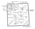
U.S. Census data map showing local municipal boundaries within Ingham County. Shaded areas represent incorporated cities.

See also
 In Spanish: Condado de Ingham para niños
