
Injune facts for kids
Quick facts for kids InjuneQueensland |
|||||||||||||||
|---|---|---|---|---|---|---|---|---|---|---|---|---|---|---|---|

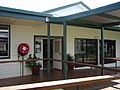
The information centre at Injune
|
|||||||||||||||

Injune
Location in Queensland
|
|||||||||||||||
| Population | 461 (2016 census) | ||||||||||||||
| • Density | 1.1214/km2 (2.904/sq mi) | ||||||||||||||
| Postcode(s) | 4454 | ||||||||||||||
| Elevation | 393 m (1,289 ft) | ||||||||||||||
| Area | 411.1 km2 (158.7 sq mi) | ||||||||||||||
| Time zone | AEST (UTC+10:00) | ||||||||||||||
| Location | |||||||||||||||
| LGA(s) | Maranoa Region | ||||||||||||||
| State electorate(s) | Warrego | ||||||||||||||
| Federal Division(s) | Maranoa | ||||||||||||||
|
|||||||||||||||
|
|||||||||||||||
Injune is a rural town and locality in the Maranoa Region, Queensland, Australia. In the 2016 census, the locality of Injune had a population of 461 people.
History
Injune Post Office opened on 11 August 1920.
Facilities
Injune has a public library, a historical railway and team train precinct, and the Injune art space.
Henricks Park
Residents of Injune district have a lively interest in the arts, strongly supported by Bungil Shire Council's Arts & Cultural Policy
Injune's local arts group, the Injune Public Space Art Group (IPSAG) is leading the development of Henricks Park. opposite the Injune Information Centre.
Climate
Injune has a subtropical climate with warm to hot summers and cool winters with rainfall concentrated in the summer months. A record low temperature of −8.0 °C (17.6 °F) is one of the coldest temperatures recorded in Queensland outside of the Darling Downs and Granite Belt along with the record low in nearby Mitchell.
| Climate data for Injune | |||||||||||||
|---|---|---|---|---|---|---|---|---|---|---|---|---|---|
| Month | Jan | Feb | Mar | Apr | May | Jun | Jul | Aug | Sep | Oct | Nov | Dec | Year |
| Record high °C (°F) | 43.8 (110.8) |
42.2 (108.0) |
40.1 (104.2) |
35.9 (96.6) |
33.3 (91.9) |
30.0 (86.0) |
34.2 (93.6) |
36.1 (97.0) |
39.3 (102.7) |
40.5 (104.9) |
42.4 (108.3) |
44.1 (111.4) |
44.1 (111.4) |
| Average high °C (°F) | 33.6 (92.5) |
32.1 (89.8) |
30.8 (87.4) |
27.7 (81.9) |
23.4 (74.1) |
20.3 (68.5) |
20.0 (68.0) |
22.3 (72.1) |
26.1 (79.0) |
29.4 (84.9) |
31.4 (88.5) |
33.1 (91.6) |
27.5 (81.5) |
| Average low °C (°F) | 19.6 (67.3) |
19.1 (66.4) |
16.4 (61.5) |
11.9 (53.4) |
7.7 (45.9) |
4.5 (40.1) |
3.1 (37.6) |
4.4 (39.9) |
8.1 (46.6) |
12.7 (54.9) |
15.9 (60.6) |
18.1 (64.6) |
11.8 (53.2) |
| Record low °C (°F) | 10.6 (51.1) |
9.4 (48.9) |
3.6 (38.5) |
−0.8 (30.6) |
−4.4 (24.1) |
−6.7 (19.9) |
−8.0 (17.6) |
−6.2 (20.8) |
−3.3 (26.1) |
−0.4 (31.3) |
3.1 (37.6) |
6.6 (43.9) |
−8.0 (17.6) |
| Average rainfall mm (inches) | 88.9 (3.50) |
88.8 (3.50) |
62.2 (2.45) |
41.8 (1.65) |
33.3 (1.31) |
30.3 (1.19) |
29.3 (1.15) |
25.2 (0.99) |
26.0 (1.02) |
47.2 (1.86) |
72.4 (2.85) |
89.1 (3.51) |
634.5 (24.98) |
| Average rainy days (≥ 0.2mm) | 7.7 | 7.0 | 5.3 | 3.9 | 3.9 | 3.9 | 3.6 | 3.3 | 3.7 | 5.9 | 7.0 | 8.2 | 63.4 |
| Source: Bureau of Meteorology | |||||||||||||
Education
Injune P-10 State School is a government primary and secondary (Prep-10) school for boys and girls on the corner of Hutton Street and Fourth Avenue (25°50′48″S 148°33′54″E / 25.8467°S 148.5651°E). In 2017, the school had an enrolment of 80 students with 12 teachers and 16 non-teaching staff (7 full-time equivalent). In 2018, the school had an enrolment of 80 students with 14 teachers (12 full-time equivalent) and 15 non-teaching staff (8 full-time equivalent).
As Injune State School only provides education to Year 10, for Years 11 and 12 the nearest school is Roma State College in Roma to the south.
Images for kids
-
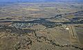
Aerial view of Injune, June 2017
-
Injune Library, 2011


