
Interstate H-1 facts for kids
Quick facts for kids
|
|
|---|---|
| Queen Lili'uokalani Freeway | |
| Lua error in Module:Infobox_road/map at line 15: attempt to index field 'wikibase' (a nil value). | |
| Route information | |
| Maintained by HDOT | |
| Length | 27.16 mi (43.71 km) |
| Existed | 1953-1959; completed in 1986–present |
| Major junctions | |
| West end | |
| East end | |
| Highway system | |
| Main route of the Interstate Highway System Main • Auxiliary • Business Routes in Hawaii |
|

Interstate H-1 (or H-1) is the most important interstate highway in Hawaii, United States, located on the island of O‘ahu. The road sees more traffic than any other interstate in Hawaii. Despite the number, this is an east-west highway–the 'H'-series (for Hawaii) numbering is done in the order in which routes were given money and built. H-1 goes from Route 93 (Farrington Highway) in Kapolei to Route 72 (Kalanianaole Highway) in Kāhala. East of Middle Street in Honolulu (exit 19A), H-1 is called the Lunalilo Freeway and is sometimes signed as such at older signs in the center of Honolulu. West of Middle Street, H-1 called the Queen Liliʻuokalani Freeway; this name is shown on some roadmaps. It is the west-most interstate highway in the United States. The route is 27.16 miles (43.71 km) long.
Images for kids
-
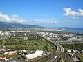
Aerial view of H-1 (looking east) from Honolulu Airport heading into downtown Honolulu
-
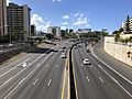
H-1 westbound viewed from Ward Avenue near downtown Honolulu
-

A 1965 photo of the H-1 under construction, looking eastbound, ending at Harding and Kapahulu Avenues.

_from_the_overpass_for_Ward_Avenue_in_Honolulu,_Oahu,_Hawaii.jpg)

See also
 In Spanish: Interestatal H-1 para niños
