
Interstate H-3 facts for kids
Quick facts for kids
|
|
|---|---|
| John A. Burns Freeway | |
| Lua error in Module:Infobox_road/map at line 15: attempt to index field 'wikibase' (a nil value). | |
| Route information | |
| Maintained by HDOT | |
| Length | 15.32 mi (24.66 km) |
| Existed | 1972:(Kamehameha Highway-Kaneohe MCBH) 1997: (Kamehameha Highway-Halawa)–present |
| Major junctions | |
| West end | |
| East end | Marine Corps Base Hawaii |
| Highway system | |
| Main route of the Interstate Highway System Main • Auxiliary • Business Routes in Hawaii |
|

Interstate H-3 is a highway in the American state of Hawaii. It begins at the Halawa Interchange with Interstates H-1 and H-201. The highway then runs along a viaduct through Halawa Valley for about 6 miles. It then goes through the Tetsuo Harano Tunnels through the Koolau Mountains. Once on the eastern end of the tunnel, the highway follows a viaduct built along the side of Haiku Valley until the Kaneohe Interchange with state route 63 (Likelike Highway) which leads into the town of Kaneohe. The highway then continues to the Halekou Interchange with state route 83 (Kamehameha Highway). Four miles farther, it reaches the main gate of Marine Corps Base Hawaii. The route is 15.32 miles (24.66 km) long.
Images for kids
-
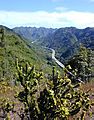
Interstate H-3 in Halawa Valley looking towards the Ko'olau crest
-
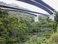
Viaducts of H-3 within Halawa Valley
-

Interstate H-3 eastbound at the exit for H-201 east
-
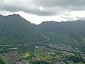
Aerial view of the tunnel's eastern entrance


_at_the_exit_for_Interstate_H-201_EAST_(Honolulu)_in_Halawa,_Oahu,_Hawaii.jpg)

See also
 In Spanish: Interestatal H-3 para niños
