Irion County, Texas facts for kids
Quick facts for kids
Irion County
|
|
|---|---|

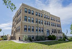
The Irion County Courthouse in Mertzon
|
|

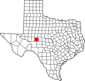
Location within the U.S. state of Texas
|
|
 Texas's location within the U.S. |
|
| Country | |
| State | |
| Founded | 1889 |
| Named for | Robert Anderson Irion |
| Seat | Mertzon |
| Largest city | Mertzon |
| Area | |
| • Total | 1,052 sq mi (2,720 km2) |
| • Land | 1,052 sq mi (2,720 km2) |
| • Water | 0.07 sq mi (0.2 km2) 0.01% |
| Population
(2020)
|
|
| • Total | 1,513 |
| • Density | 1.4382/sq mi (0.5553/km2) |
| Time zone | UTC−6 (Central) |
| • Summer (DST) | UTC−5 (CDT) |
| Congressional district | 11th |
Irion County ( eye-REE-ən) is a county located on the Edwards Plateau in the U.S. state of Texas. As of the 2020 census, its population was 1,513. Its county seat is Mertzon. The county is named for Robert Anderson Irion, a secretary of state of the Republic of Texas.
Irion County is included in the San Angelo metropolitan statistical area.
Contents
History
- First inhabitants Tonkawa and Kickapoo.
- 1650 Captains Hernán Martín and Diego del Castillo explore the region.
- 1684 Juan Domínguez de Mendoza and Nicolás López report on local Indians.
- 1761 Spanish soldier Felipe Rábago y Terán passes through the area.
- 1858 -1861 Butterfield Overland Mail crosses the region.
- 1876 John Arden brings the first flock of sheep from California. Billy Childress establishes the longhorn 7D Ranch.
- 1889 The Texas legislature forms Irion County from Tom Green County. Sherwood becomes the county seat.
- 1928 Oil is discovered in Irion County.
- 1936 Mertzon becomes county seat.
Geography
According to the U.S. Census Bureau, the county has a total area of 1,052 square miles (2,720 km2), of which 1,052 square miles (2,720 km2) is land and 0.07 square miles (0.18 km2) (0.01%) is water. The Spraberry Trend, the third-largest oil field in the United States by remaining reserves, underlies much of the county.
Major Highways
Adjacent counties
- Tom Green County (north and east)
- Schleicher County (southeast)
- Crockett County (southwest)
- Reagan County (west)
Demographics
| Historical population | |||
|---|---|---|---|
| Census | Pop. | %± | |
| 1890 | 870 | — | |
| 1900 | 848 | −2.5% | |
| 1910 | 1,283 | 51.3% | |
| 1920 | 1,610 | 25.5% | |
| 1930 | 2,049 | 27.3% | |
| 1940 | 1,963 | −4.2% | |
| 1950 | 1,590 | −19.0% | |
| 1960 | 1,183 | −25.6% | |
| 1970 | 1,070 | −9.6% | |
| 1980 | 1,386 | 29.5% | |
| 1990 | 1,629 | 17.5% | |
| 2000 | 1,771 | 8.7% | |
| 2010 | 1,599 | −9.7% | |
| 2020 | 1,513 | −5.4% | |
| U.S. Decennial Census 1850–2010 2010 2020 |
|||
2020 census
| Race / Ethnicity | Pop 2010 | Pop 2020 | % 2010 | % 2020 |
|---|---|---|---|---|
| White alone (NH) | 1,153 | 1,112 | 72.11% | 73.50% |
| Black or African American alone (NH) | 11 | 6 | 0.69% | 0.40% |
| Native American or Alaska Native alone (NH) | 7 | 9 | 0.44% | 0.59% |
| Asian alone (NH) | 3 | 0 | 0.19% | 0.00% |
| Pacific Islander alone (NH) | 0 | 1 | 0.00% | 0.07% |
| Some Other Race alone (NH) | 0 | 1 | 0.00% | 0.07% |
| Mixed Race/Multi-Racial (NH) | 18 | 35 | 1.13% | 2.31% |
| Hispanic or Latino (any race) | 407 | 349 | 25.45% | 23.07% |
| Total | 1,599 | 1,513 | 100.00% | 100.00% |
Note: the US Census treats Hispanic/Latino as an ethnic category. This table excludes Latinos from the racial categories and assigns them to a separate category. Hispanics/Latinos can be of any race.
Communities
City
- Mertzon (county seat)
Unincorporated community
Ghost Town
Notable natives
See also
 In Spanish: Condado de Irion para niños

