
Iseltwald facts for kids
Quick facts for kids
Iseltwald
|
||
|---|---|---|
 |
||
|
||
| Country | Switzerland | |
| Canton | Bern | |
| District | {{{district}}} | |
| Area | ||
| • Total | 21.91 km2 (8.46 sq mi) | |
| Elevation | 566 m (1,857 ft) | |
| Postal code |
3807
|
|
| Surrounded by | Bönigen, Brienz, Grindelwald, Gündlischwand, Lütschental, Lake Thun | |

Iseltwald is a village and municipality on the southern shore of Lake Brienz in the Bernese Oberland region of Switzerland. Politically, the municipality is located in the Interlaken-Oberhasli administrative district of the canton of Bern.
The traditional local economy relied on fish from Lake Brienz, farming in the valleys and seasonal alpine herding and farming in the alpine meadows. A glass blowing factory opened between 1680 and 1696 and operated until 1715. Beginning in 1871, tourists began coming across the lake on steam ships. However, there was only one large road into the village until 1988. Today the local economy is based on tourism, agriculture, fishing and timber harvesting.
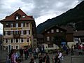
The entire village of Iseltwald is designated as part of the Inventory of Swiss Heritage Sites. Iseltwald is a popular destination for backpackers and skiers in the Jungfraujoch region. The village has a host of backpacker hostels and Bed and Breakfasts
Geography
The village of Iseltwalt lies on a delta at the south bank of Lake Brienz. It is 14 km (8.7 mi) from Interlaken, the road mostly running along Lake Brienz. Besides the village of Iseltwald, the municipality includes the hamlets of Furen, Sengg and Isch, as well as a number of scattered farm houses.
The municipality's area also includes a large area of mountainside along the south shore of the lake, of which the lower areas are heavily wooded. These slopes extend up to the summit of the Faulhorn mountain, at an altitude of 2,680 m (8,790 ft).
Iseltwald has an area of 21.91 km2 (8.46 sq mi). Of this area, 6.85 km2 (2.64 sq mi) or 31.4% is used for agricultural purposes, while 10.44 km2 (4.03 sq mi) or 47.8% is forested. Of the rest of the land, 0.51 km2 (0.20 sq mi) or 2.3% is settled (buildings or roads), 0.08 km2 (20 acres) or 0.4% is either rivers or lakes and 3.97 km2 (1.53 sq mi) or 18.2% is unproductive land.
Of the built up area, housing and buildings made up 1.0% and transportation infrastructure made up 1.1%. Out of the forested land, 42.5% of the total land area is heavily forested and 3.2% is covered with orchards or small clusters of trees. Of the agricultural land, 4.6% is pastures and 26.7% is used for alpine pastures. All the water in the municipality is flowing water. Of the unproductive areas, 7.9% is unproductive vegetation and 10.3% is too rocky for vegetation.
On 31 December 2009 Amtsbezirk Interlaken, the municipality's former district, was dissolved. On the following day, 1 January 2010, it joined the newly created Verwaltungskreis Interlaken-Oberhasli.
Most of the population (as of 2000[update]) speaks German (422 or 97.2%) as their first language, French is the second most common (3 or 0.7%) and Italian is the third (3 or 0.7%).
Images for kids
-
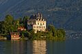
View of the peninsula and former castle (now Rehabilitation Center of Seeburg).
-
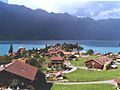
Iseltwalt on Lake Brienz
-
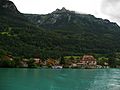
Lakefront of Iseltwald
-
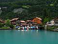
Houses along the lakefront
-
Hotel Strand on the waterfront in Iseltwald


See also
 In Spanish: Iseltwald para niños
