
Isenthal facts for kids
Quick facts for kids
Isenthal
|
||
|---|---|---|
 |
||
|
||
| Country | Switzerland | |
| Canton | Uri | |
| District | n.a. | |
| Area | ||
| • Total | 60.97 km2 (23.54 sq mi) | |
| Elevation | 771 m (2,530 ft) | |
| Population
(Dec 2020 )
|
||
| • Total | 476 | |
| • Density | 7.807/km2 (20.220/sq mi) | |
| Postal code |
6461
|
|
| Surrounded by | Attinghausen, Bauen, Beckenried (NW), Emmetten (NW), Engelberg (OW), Flüelen, Seedorf, Seelisberg, Wolfenschiessen (NW) | |

Isenthal is a municipality in the canton of Uri in Switzerland.
Contents
History
Isenthal is first mentioned in 1280 as Yseltal.
Geography
Isenthal has an area, as of 2006[update], of 61 km2 (24 sq mi). Of this area, 27.9% is used for agricultural purposes, while 26.2% is forested. Of the rest of the land, 0.6% is settled (buildings or roads) and the remainder (45.3%) is non-productive (rivers, glaciers or mountains). In the 1993 land survey[update], 21.4% of the total land area was heavily forested, while 1.4% is covered in small trees and shrubbery.
Of the agricultural land, 0.0% is used for farming or pastures, while 5.7% is used for orchards or vine crops and 22.2% is used for alpine pastures. Of the settled areas, 0.3% is covered with buildings, and 0.2% is transportation infrastructure. Of the unproductive areas, 0.9% is unproductive flowing water (rivers), 35.6% is too rocky for vegatation, and 8.8% is other unproductive land.
The municipality is located at the intersection of the Sernftal and the Grosstal. It consists of the village of Isenthal and widely scattered small settlements.
Images for kids
-
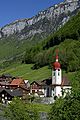
Isenthal Church and village
-
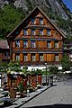
Cemetery and bank in Isenthal


See also
 In Spanish: Isenthal para niños
