Isla de Pascua (commune) facts for kids
Quick facts for kids
Isla de Pascua
|
|||
|---|---|---|---|
|
|||

|
|||
| Country | Chile | ||
| Region | Valparaíso | ||
| Province | Isla de Pascua | ||
| Seat | Hanga Roa | ||
| Government | |||
| • Type | Municipality | ||
| • Body | Municipal council | ||
| Area | |||
| • Total | 163.6 km2 (63.2 sq mi) | ||
| Highest elevation | 507 m (1,663 ft) | ||
| Lowest elevation | 0 m (0 ft) | ||
| Population
(2017 census)
|
|||
| • Total | 7,750 | ||
| • Density | 47.37/km2 (122.69/sq mi) | ||
| Time zone | UTC−6 (CLT) | ||
| • Summer (DST) | UTC−5 (CLST) | ||
| Country Code | +56 | ||
| Currency | Peso (CLP) | ||
| Language | Spanish, Rapa Nui | ||
| Driving side | right | ||
| Website | http://www.municipalidaddeisladepascua.cl | ||
| NGA UFI=-905269 | |||
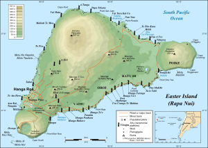
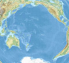
Isla de Pascua (Easter Island) is a Chilean commune with a special regime, located within Isla de Pascua Province in Valparaíso Region. It is the only commune in Isla de Pascua Province, comprising Easter Island and Isla Salas y Gómez. Its capital is Hanga Roa, located in the southwestern area of the main island, where most of the local population resides.
Local government
The municipality of Isla de Pascua is led by mayor Pedro Edmunds Paoa (PRO), who is accompanied in the Municipal Council by:
- Mai Teao Osorio (RN)
- Marta Hotus Tuki (PDC)
- María Icka Araki (PDC)
- Ricardo Espinoza Alvarado (PPD)
- Julio Hotus Salinas (PPD)
- Juan Haoa Hotus (Ind./Evópoli)
See also
 In Spanish: Isla de Pascua (comuna) para niños

All content from Kiddle encyclopedia articles (including the article images and facts) can be freely used under Attribution-ShareAlike license, unless stated otherwise. Cite this article:
Isla de Pascua (commune) Facts for Kids. Kiddle Encyclopedia.


