
Israeli West Bank barrier facts for kids


The Israeli West Bank barrier, comprising the West Bank Wall and the West Bank fence, is a separation barrier built by Israel along the Green Line and inside parts of the West Bank. Israel describes the wall as a necessary security barrier against Palestinian political violence; whereas Palestinians describe it as an element of racial segregation and a representation of Israeli apartheid, who often call it "Wall of Apartheid". At a total length of 708 kilometres (440 mi) upon completion, the route traced by the barrier is more than double the length of the Green Line, with 15% of its length running along the Green Line or inside Israel, and the remaining 85% running as much as 18 kilometres (11 mi) inside the West Bank, effectively isolating about 9% of the land and approximately 25,000 Palestinians from the rest of the Palestinian territory.
The barrier was built by Israel following a wave of Palestinian political violence and incidents of terrorism inside Israel during the Second Intifada, which began in September 2000 and ended in February 2005. While the barrier was initially presented as a temporary security measure at a time of heightened tensions, it has since been associated with a future political border between Israel and the State of Palestine.
The barrier has drawn criticism from Palestinians, human rights groups, and members of the international community, who have all argued that it serves as evidence of Israel's intent to annex Palestinian land under the guise of security. It has also been alleged that the construction of the wall aims to undermine the Israeli–Palestinian peace process by unilaterally establishing new de facto borders. Key points of dispute are that it substantially deviates eastward from the Green Line, severely restricts the travel of many Palestinians, and impairs their ability to commute to work within the West Bank or to Israel. The International Court of Justice issued an advisory opinion finding that the barrier qualifies as a violation of international law. In 2003, the United Nations General Assembly adopted a resolution that charged Israel's building of the barrier to be a violation of international law and demanded its removal by a vote of 144–4 with 12 abstentions.
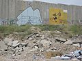
The walled sections of the barrier have become a canvas for graffiti art, with its Palestinian side illustrating opposition to the barrier, Palestinian resistance, their right to return, as well as human rights in general.
Names

In Hebrew, descriptions include: "separation fence" (, Geder HaHafrada); "separation wall" (Hebrew: חומת ההפרדה, Ḥomat HaHafrada) and "security fence" (גדר הביטחון, Geder HaBitaḥon).
In Arabic, it is called "wall of apartheid"/"racial segregation wall" , jidār al-faṣl al-‘unṣuriyy, indicating an allegation of Israeli apartheid.
In English, the BBC's style guide uses the terms "barrier" (sometimes "separation barrier" or "West Bank barrier") as do The Economist, PBS and The New York Times. The Israeli Ministry of Foreign Affairs uses the phrase "security fence" in English. The International Court of Justice has used the term "wall" explaining "the other expressions sometimes employed are no more accurate if understood in the physical sense." It is also referred to as the "Apartheid Wall" or "Apartheid Fence" in a derogatory manner. "Seam zone" (Hebrew: מרחב התפר) refers to the land between the 1949 Armistice Agreement Line and the fence.
Structure

The barrier is described by the Israeli Defense Forces as a "multi-layered composite obstacle", with parts of it being consisting of a 9 metres (30 ft) high concrete wall, while others stretches consist of a multi-layered fence system, with three fences with pyramid-shaped stacks of barbed wire on the two outer fences and a lighter-weight fence with intrusion detection equipment in the middle; an anti-vehicle ditch; patrol roads on both sides; and a smooth strip of sand for "intrusion tracking".
Where the multi-layered fence system is employed, it contains an exclusion area of 60-metre (200 ft) in width on average, with some sections having an exclusion area that reaches up to 100 metres (330 ft). The concrete wall has a width of 3 metres (9.8 ft), and the wall is 9 metres (30 ft) high.
Route


The barrier runs partly along or near the 1949 Jordanian–Israeli armistice line ("Green Line") and partly through the Israeli-occupied West Bank diverging eastward from the armistice line by up to 20 km (12 mi) to include on the western side several of the areas with concentrations of highly populated Israeli settlements, such as East Jerusalem, the Ariel Bloc (Ariel, Karnei Shomron, Kedumim, Immanuel etc.), Gush Etzion, Givat Ze'ev, Oranit, and Maale Adumim.
The barrier nearly encircles some Palestinian towns, about 20% follows the armistice line, and a projected 77,000 ha (191,000 acres) or about 13.5% of the West Bank area is on the west side of the wall. According to a study of the April 2006 route by the Israeli human rights organization B'Tselem, 8.5% of the West Bank area will be on the Israeli side of the barrier after completion, and 3.4% partly or completely surrounded on the eastern side. Some 27,520 to 31,000 Palestinians will be captured on the Israeli side. Another 124,000, on the other hand, will effectively be controlled and isolated. Some 230,000 Palestinians in Jerusalem will be placed on the West Bank side. Most of the barrier was built at the northern and western edges of the West Bank, mostly beyond the Green Line and created 9 enclaves, which enclosed 15,783 ha (39,000 acres). An additional barrier, circa 10 km long, run south of Ramallah.
Israel states that the topography does not permit putting the barrier along the Green Line in some places because hills or tall buildings on the Palestinian side would make the barrier ineffective against terrorism. The International Court of Justice states that in such cases it is only legal to build the barrier inside Israel.
The barrier route has been challenged in court and changed several times. Argument presented to the court has reiterated that the cease-fire line of 1949 was negotiated "without prejudice to future territorial settlements or boundary lines" (Art. VI.9).
Legality
United Nations Security Council
In October 2003, a United Nations resolution to declare the barrier illegal where it deviates from the Green Line and should be torn down was vetoed by the US in the United Nations Security Council.
On May 19, 2004, the UN passed Security Council Resolution 1544 reiterating the obligation of Israel, the occupying Power, to abide scrupulously by its legal obligations and responsibilities under the Fourth Geneva Convention, and called on Israel to address its security needs within the boundaries of international law. In a special emergency session of the General Assembly, the United Nations asked the International Court of Justice [ICJ] to evaluate the legal status of the barrier. Israel chose not to accept ICJ jurisdiction nor make oral statements, and instead submitted a 246-page written statement containing the views of the Government of Israel on Jurisdiction and Propriety to the Court.
International Court of Justice
In a 2004 advisory opinion by the International Court of Justice, "Israel cannot rely on a right of self-defence or on a state of necessity in order to preclude the wrongfulness of the construction of the wall". The Court asserted that "the construction of the wall, and its associated régime, are contrary to international law."
So in the July 9, 2004 advisory opinion the ICJ advised that the barrier is a violation of international law, that it should be removed, that Arab residents should be compensated for any damage done, and that other states take action to obtain Israel's compliance with the Fourth Geneva Convention. The ICJ said that an occupying power cannot claim that the lawful inhabitants of the occupied territory constitute a "foreign" threat for the purposes of Article 51 of the UN Charter. It also explained that necessity may constitute a circumstance precluding wrongfulness under certain very limited circumstances, but that Article 25 of the International Law Commission's Articles on Responsibility of States for Internationally Wrongful Acts (ARSIWA) bars a defense of necessity if the State has contributed to the situation of necessity. The Court cited illegal interference by the government of Israel with the Palestinian's national right to self-determination; and land confiscations, house demolitions, the creation of enclaves, and restrictions on movement and access to water, food, education, health care, work, and an adequate standard of living in violation of Israel's obligations under international law. The Court also said that Israeli settlements had been established and that Palestinians had been displaced in violation of Article 49, paragraph 6, of the Fourth Geneva Convention. On request of the ICJ, Palestine submitted a copious statement. The UN Fact Finding Mission and several UN Rapporteurs subsequently said that in the movement and access policy there has been a violation of the right not to be discriminated against on the basis of race or national origin.
Images for kids
-
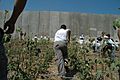
Palestinian children running towards the barrier, August 2004
-
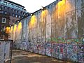
Replica section of the Israeli Barrier, built in London in 2013, as part of the international protest against the Israeli wall
-
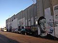
Graffiti depicting U.S. President Donald Trump and Mark Zuckerberg on the Israeli barrier in Bethlehem, July 2018
-
Graffiti paintings on the wall by British graffiti artist Banksy
-
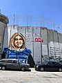
Art depicting slain journalist Shireen Abu Akleh, West Bank separation wall in Bethlehem, 2022


See also
 In Spanish: Barrera israelí de Cisjordania para niños
- List of walls, particularly List of walls#Walls in use today
