
Jayuya, Puerto Rico facts for kids
Quick facts for kids
Jayuya
Municipio Autónomo de Jayuya
|
|||
|---|---|---|---|
|
Town and Municipality
|
|||

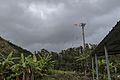
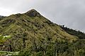
Lush vegetation and mountains in Jayuya
|
|||
|
|||
| Nickname(s):
La Capital Indigena
|
|||
| Anthem: "Ante nos se yergue" | |||

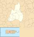
Map of Puerto Rico highlighting Jayuya Municipality
|
|||
| Commonwealth | |||
| Founded | 1911 | ||
| Barrios | |||
| Area | |||
| • Total | 39.4 sq mi (102.1 km2) | ||
| Population
(2020)
|
|||
| • Total | 14,779 | ||
| • Density | 374.90/sq mi (144.75/km2) | ||
| Racial groups | |||
| • 2020 Census | 52.4% Multiracial 23.3% White 7.5% Black 0.5% American Ind/AN 21.3% Other |
||
| Time zone | UTC−4 (AST) | ||
| ZIP Code |
00664
|
||
| Area code(s) | 787/939 | ||
| Major routes | |||


Jayuya is a town and municipality of Puerto Rico located in the mountainous center region of the island, north of Ponce; east of Utuado; and west of Ciales. Jayuya is spread over 10 barrios and Jayuya Pueblo (the downtown and administrative center of the city). It is the principal city of the Jayuya Micropolitan Statistical Area.
Named after the Taíno tribal leader, Hayuya, Jayuya is known for its skilled wood carvers. Among its monuments are the statue of Nemesio Canales and the bust of Hayuya, both by the Puerto Rican sculptor Tomás Batista.
Contents
History
The town of Jayuya was founded in 1911, but history traces non- indigenous settlers living in the region as far back as 1878. At that time, a small community was established there, separated from the larger cities of the coasts with little to no communication. Near the end of the 19th century, the town focused on the production of coffee, which greatly boosted the local economy.
In 1911, the town was officially declared a municipality with a population of more than 9,000.
In 1950, the town was the setting of the Jayuya Uprising, in which Nationalists started a revolt against the Government of the United States led by Blanca Canales, a social worker, and her cousins, Elio and Doris Torresola. Canales led the group into the town square and gave a speech, declaring Puerto Rico an independent republic. The police station was later attacked, telephone lines cut, and the post office burned to the ground. One police officer was killed and three others wounded in these attacks. The group held the town for three days, until it was bombed by U. S. planes supporting a ground attack by the Puerto Rican National Guard. Even though an extensive part of the town was destroyed, news of the bombing was not reported outside of Puerto Rico. It was called an incident between Puerto Ricans by the media on the mainland.
Symbols
Flag
The flag is rectangular in shape and derives its symbolism from the Coat of Arms. It symbolizes the spirit of people proud of their Taíno heritage and their hospitality.
Coat of arms
Jayuya's Coat of Arms consists of a shield with a three tower crown above, which is standard for municipalities. Inside the shield, centered at the top, a crown representing Chief Hayuya's monarchy. In the center a green band with a white border representing the Tres Picachos (Three Peaks) mountains. The green color symbolizes the countryside and the town's matron, La Virgen de la Monserrate. At the bottom of the shield, is a petroglyph known as the Taíno Sun found in Jayuya.
Geography

Jayuya is located in the center of the island of Puerto Rico, in the middle of the Cordillera Central. Due to this location, its terrain is mostly rough and steep. Some of the highest mountains of the island are located in this region, including Monte Jayuya, Cerro Rosa, Tres Picachos and the highest mountain of the island, Cerro Punta 1,338m (4,389 ft).
The town's total area is estimated at 39.4 square miles (102.05 km²). Part of the Toro Negro State Forest is located within the municipality of Jayuya. Rivers like Río Naranjito and Río Yunes, as well as the Río Grande de Jayuya and its various affluents, flow through this municipality.
Climate
As in most municipalities located in the mountain region, the climate is mostly cool with temperatures in the 80 to 70 °F (27 to 21 °C) range. However, they are known to go as low as 50 or 60 °F (10 or 16 °C) during some winters.
Wards
- Coabey
- Collores
- Hoyo Planes
- Hoyo Fríos
- Jardines
- Jauca
- Jayuya Abajo
- Jayuya Pueblo
- Mameyes Arriba
- La Pica
- Las Arenas
- Monserrate
- Río Grande
- Santa Rosa
- Saliente
- Vegalinda
- Veguitas
- Zama
Culture
Festivals and events
There are several celebrations and festivals held at Jayuya throughout the year. Two of the most known are the Tomato Festival, held in February, and the Festival Indígena (Indian Festival) held in November.
Tourism

Due to its location, Jayuya is usually mentioned as the obligatory municipality to visit when visiting the center of the island of Puerto Rico. There are several landmarks for tourists to consider like the Nemesio Canales Museum and the Cemí Museum, both located in the same valley. Also, the Taíno Tomb in the city's downtown has the remains of a Taíno Indian found in an excavation. Nearby, there's a monument to Chief Hayuya, cacique of the region.
In the outskirts of the city, tourists can visit the Cerro de Punta, highest peak in the island of Puerto Rico, as well as the other mountains mentioned (Tres Picachos, for example). The Toro Negro State Forest can also be reached through the city.
Additional information
- Cerro de Punta
- July 11, 1883 - The first parish was established
- March 9, 1911 - Municipality was established
- Mayte Vega Torres - National Winner Walker, Athlete
Economy
Agriculture
Jayuya's economy has always depended greatly on agriculture. Products like coffee, tomato, and other vegetables are produced and distributed in the region. Livestock is another part of the city's economy.
Industry
In the middle of the 20th century, several manufacturing industries established in Jayuya, aiming to revitalize the economy as well as provide work for the residents. Some of the companies currently in the city are Baxter Healthcare and Abbott Laboratories. A bridge used by these companies for the delivery of their materials to their plants was destroyed by Hurricane Maria. Work was set to begin on the bridge in 2019.
Demographics
| Historical population | |||
|---|---|---|---|
| Census | Pop. | %± | |
| 1920 | 12,463 | — | |
| 1930 | 12,223 | −1.9% | |
| 1940 | 14,589 | 19.4% | |
| 1950 | 15,113 | 3.6% | |
| 1960 | 14,633 | −3.2% | |
| 1970 | 13,588 | −7.1% | |
| 1980 | 14,722 | 8.3% | |
| 1990 | 15,527 | 5.5% | |
| 2000 | 17,318 | 11.5% | |
| 2010 | 16,642 | −3.9% | |
| 2020 | 14,779 | −11.2% | |
| U.S. Decennial Census 1920-1930 1930-1950 1960-2000 2010 2020 |
|||
Education
As all other municipalities in the island, Jayuya is part of the Puerto Rico Department of Education. It has several elementary schools distributed throughout the city's barrios. However, there's currently only one public high school, Josefina León Zayas High School, located in the city's downtown. The high school is LEED certified, for having a green-building design.
The Metropolitan University, a private institution, has a campus in the municipality's downtown area.
Transportation
There are 34 bridges in Jayuya.
Images for kids
-
On April 21, 2018, the United States Army Corps of Engineers was working on electrical infrastructure in Jayuya.
-
Subdivisions of Jayuya.
-
Hacienda San Pedro
-
School damaged by Hurricane María in 2017
-
Mountain in Jayuya
-
Hacienda Gripiñas in Jayuya


See also
 In Spanish: Jayuya para niños
