
Jefferson City, Missouri facts for kids
Quick facts for kids
Jefferson City, Missouri
|
|||
|---|---|---|---|
 |
|||
|
|||
| Nickname(s):
Jeff
|
|||
| Motto(s):
Jefferson City
|
|||
 |
|||

U.S. Census Map
|
|||

Jefferson City, Missouri
Location in Missouri

Jefferson City, Missouri
Location in the United States
|
|||
| Country | United States | ||
| State | Missouri | ||
| Counties | Callaway, Cole | ||
| Founded | 1821 | ||
| Incorporated | 1825 | ||
| Named for | Thomas Jefferson | ||
| Government | |||
| • Type | Mayor–council | ||
| Area | |||
| • State capital | 37.65 sq mi (97.51 km2) | ||
| • Land | 36.05 sq mi (93.38 km2) | ||
| • Water | 1.60 sq mi (4.13 km2) | ||
| Elevation | 630 ft (192 m) | ||
| Population
(2020)
|
|||
| • State capital | 43,228 | ||
| • Density | 1,148.15/sq mi (443.319/km2) | ||
| • Metro | 149,807 | ||
| Time zone | UTC−6 (CST) | ||
| • Summer (DST) | UTC−5 (CDT) | ||
| ZIP codes |
65101-65111
|
||
| Area code(s) | 573 | ||
| FIPS code | 29-37000 | ||
| GNIS ID | 0758233 | ||
| U.S. Routes | |||
| State highway | |||
| Waterways | Missouri River | ||
| Public transit | JeffTran | ||


Jefferson City, informally Jeff City, is the capital of Missouri. It had a population of 43,228 at the 2020 census, ranking as the 15th most populous city in the state. It is also the county seat of Cole County and the principal city of the Jefferson City Metropolitan Statistical Area, the second-most-populous metropolitan area in Mid-Missouri and the fifth-largest in the state. Most of the city is in Cole County, with a small northern section extending into Callaway County. Jefferson City is named for Thomas Jefferson, the third President of the United States.
Jefferson City is located on the northern edge of the Ozark Plateau on the southern side of the Missouri River in a region known as Mid-Missouri, that is roughly mid-way between the state's two large urban areas of Kansas City and St. Louis. It is 29 miles south of Columbia, Missouri, and sits at the western edge of the Missouri Rhineland, one of the major wine-producing regions of the Midwest. The city is dominated by the domed Capitol, which rises from a bluff overlooking the Missouri River to the north; Lewis and Clark passed the bluff on their historic expedition upriver before Europeans established any settlement there.
Many of Jefferson City's primary employers are in service and manufacturing industries. Jefferson City is also home to Lincoln University, a public historically black land-grant university founded in 1866 by the 62nd Regiment of U.S. Colored Troops with support from the 65th Regiment of U.S. Colored Troops.
Contents
History


.jpg)
In pre-Columbian times, this region was home of an ancient people known only as the "Mound Builders". They were no longer present by the time of the first white settlers, having been replaced by Osage Indians. When the Missouri Territory was organized in 1812, St. Louis was Missouri's seat of government, and St. Charles would serve as the next capital.
In the middle of the state, Jefferson City was chosen as the new capital in 1821 when Thomas Jefferson was still living. The village first was called "Lohman's Landing", and when the legislature decided to relocate there, they proposed the name "Missouriopolis" before settling on "Jefferson City". For years, this village was little more than a trading post located in the wilderness about midway between St. Louis and Kansas City. In 1825, the settlement was incorporated as a city and a year later, the Missouri legislature first met in Jefferson City.
Jefferson City was chosen as the site of a state prison. This prison, named the Missouri State Penitentiary, opened in 1836. This prison was home to multiple infamous Americans, including former heavyweight champion Sonny Liston, assassin James Earl Ray, and bank robber Charles "Pretty Boy" Floyd. During the Civil War, Jefferson City was occupied by Union troops and the elected state legislature was driven from Jefferson City by Union General Nathaniel Lyon. Some of the legislators later reconvened in Neosho, Missouri and passed an ordinance of secession. Missouri was claimed by both the Confederacy and the Union, just like the neighboring state Kentucky. Missourians were strongly divided and many people in the state—especially in St. Louis—supported the Union, while other areas (such as Missouri's Little Dixie) were strongly pro-Confederate along the Missouri River between Jefferson City and Kansas City.
German immigrants created vineyards in small towns on either side of the Missouri River, especially on the north from the city east to Marthasville, located outside of St. Louis. Known as the "Missouri Rhineland" for its vineyards and first established by German immigrants in the mid-1800s, this region has become part of the agricultural and tourist economy.
Geography
According to the United States Census Bureau, the city has a total area of 37.58 square miles (97.33 km2), of which, 35.95 square miles (93.11 km2) is land and 1.63 square miles (4.22 km2) is water.
Climate
Jefferson City has a transitional climate between a humid subtropical and humid continental climate with hot, rainy summers and cold winters. Thunderstorms are common in both the spring and summer. Light snow is common during the winter, although about half of wintertime precipitation falls as rain.
| Climate data for Jefferson City, Missouri, 1981–2010 normals | |||||||||||||
|---|---|---|---|---|---|---|---|---|---|---|---|---|---|
| Month | Jan | Feb | Mar | Apr | May | Jun | Jul | Aug | Sep | Oct | Nov | Dec | Year |
| Record high °F (°C) | 79 (26) |
89 (32) |
97 (36) |
96 (36) |
102 (39) |
105 (41) |
112 (44) |
111 (44) |
107 (42) |
96 (36) |
87 (31) |
79 (26) |
112 (44) |
| Average high °F (°C) | 39.9 (4.4) |
45.4 (7.4) |
55.5 (13.1) |
66.7 (19.3) |
75.1 (23.9) |
83.5 (28.6) |
88.3 (31.3) |
87.8 (31.0) |
79.8 (26.6) |
68.5 (20.3) |
55.8 (13.2) |
42.5 (5.8) |
65.7 (18.7) |
| Average low °F (°C) | 19.9 (−6.7) |
23.6 (−4.7) |
32.2 (0.1) |
43.1 (6.2) |
53.1 (11.7) |
62.8 (17.1) |
67.2 (19.6) |
65.4 (18.6) |
56.0 (13.3) |
44.0 (6.7) |
33.9 (1.1) |
23.0 (−5.0) |
43.7 (6.5) |
| Record low °F (°C) | −20 (−29) |
−13 (−25) |
−16 (−27) |
13 (−11) |
24 (−4) |
38 (3) |
42 (6) |
41 (5) |
29 (−2) |
14 (−10) |
1 (−17) |
−21 (−29) |
−21 (−29) |
| Average precipitation inches (mm) | 1.93 (49) |
2.29 (58) |
3.00 (76) |
4.16 (106) |
5.18 (132) |
4.39 (112) |
4.31 (109) |
3.99 (101) |
4.15 (105) |
3.35 (85) |
3.61 (92) |
2.67 (68) |
43.03 (1,093) |
| Average snowfall inches (cm) | 4.8 (12) |
3.4 (8.6) |
1.4 (3.6) |
.1 (0.25) |
0 (0) |
0 (0) |
0 (0) |
0 (0) |
0 (0) |
0 (0) |
.3 (0.76) |
3.8 (9.7) |
13.8 (34.91) |
| Source: NOAA | |||||||||||||
Demographics
| Historical population | |||
|---|---|---|---|
| Census | Pop. | %± | |
| 1860 | 3,082 | — | |
| 1870 | 4,420 | 43.4% | |
| 1880 | 5,271 | 19.3% | |
| 1890 | 6,742 | 27.9% | |
| 1900 | 9,664 | 43.3% | |
| 1910 | 11,850 | 22.6% | |
| 1920 | 14,490 | 22.3% | |
| 1930 | 21,596 | 49.0% | |
| 1940 | 24,268 | 12.4% | |
| 1950 | 25,099 | 3.4% | |
| 1960 | 28,228 | 12.5% | |
| 1970 | 32,407 | 14.8% | |
| 1980 | 33,619 | 3.7% | |
| 1990 | 35,481 | 5.5% | |
| 2000 | 39,636 | 11.7% | |
| 2010 | 43,079 | 8.7% | |
| 2020 | 43,228 | 0.3% | |
| U.S. Decennial Census | |||
2010 census
At the 2010 census there were 43,079 people in 17,278 households, including 9,969 families, in the city. The population density was 1,198.3 inhabitants per square mile (462.7/km2). There were 18,852 housing units at an average density of 524.4 per square mile (202.5/km2). The racial makeup of the city was 78.0% White, 16.9% African American, 0.3% Native American, 1.8% Asian, 0.1% Pacific Islander, 0.8% from other races, and 2.2% from two or more races. Hispanic or Latino people of any race were 2.6%.
Of the 17,278 households 28.8% had children under the age of 18 living with them, 41.6% were married couples living together, 12.4% had a female householder with no husband present, 3.7% had a male householder with no wife present, and 42.3% were non-families. 36.2% of households were one person and 11.5% were one person aged 65 or older. The average household size was 2.21 and the average family size was 2.89.
The age distribution was 20.9% of residents under the age of 18, 10.3% between the ages of 18 and 24, 28.6% from 25 to 44, 26.8% from 45 to 64, and 13.4% 65 or older. The median age was 37.5 years. The gender makeup of the city was 51.2% male and 48.8% female.
Infrastructure
Transportation
Highways
Federal highways are U.S. Routes 50, 54, and 63. Missouri Routes 179 and 94 also run through the city. Jefferson City is one of the four state capitals that is not served by an Interstate highway; Interstate 70 passes by the city 30 miles (48 km) to the north in Columbia.
Airports
The city is served by Columbia Regional Airport and nearby Jefferson City Memorial Airport.
Public transportation
Local transit
JeffTran, the city operated public transit system, provides year-round bus service during traditional weekday business hours, but is currently considering the extension of service hours to include evenings and weekends.
Intercity transit
The Jefferson City station, located in the former Union Hotel at Jefferson Landing State Historic Site, is one of the Missouri River Runner train stops between Kansas City and St. Louis, provided by Amtrak, the sole intercity passenger railroad service in the United States.
A Greyhound bus stop near the Eastland Drive Convenient Food Mart also provides intercity transit. Jefferson City Memorial Airport, which is located in the Jefferson City limits of Callaway County, Missouri, serves general aviation but has no scheduled commercial airline service.
Healthcare
Jefferson City is home to SSM Health St. Mary's Hospital which has 154 beds.
Sister cities
- Jefferson City is sister city to the German city of Münchberg. The historically German section of Jefferson City is called "Old Munichburg".
Economy
| Jefferson City's top employers (2016) | ||
|---|---|---|
| Rank | Employers | # of employees |
| 1 | State of Missouri | 14,223 |
| 2 | Capital Region Medical Center | 1,573 |
| 3 | Scholastic | 1,500 |
| 4 | Jefferson City Public Schools | 1,489 |
| 5 | SSM Health-St. Mary's Hospital | 1,154 |
| 6 | Central Bancompany | 967 |
| 7 | ABB Power T&D Company | 775 |
| 8 | Jefferson City Medical Group | 633 |
| 9 | Wal-Mart Supercenter | 622 |
| 10 | Unilever | 510 |
| No change reported in 2017 | ||
Jefferson City's economy is driven by its residents, citizens of surrounding communities, and tourists.
Business
Jefferson City's economy is based on the government, health care, manufacturing, retail, education, and tourism industries. In 2016, Jefferson City's gross metropolitan product was $7.366 billion and Missouri's real total gross domestic product was $260.309 billion, making Jefferson City's economy 2.829% of the total gross state product of Missouri.
Central Bancompany, Hawthorn Bancshares, Capital Region Medical Center, and Arris Pizza all have their headquarters in Jefferson City. Jefferson City is also known for Central Dairy, whose products are shipped statewide.
Tourism
Tourists are drawn to the Missouri State Capitol, St. Peter Church (adjacent to the capitol), Missouri State Penitentiary, Missouri Governor's Mansion, and Missouri State Museum. Lincoln University, ranked by U.S. News & World Report in 2007 as a top educational institution for international students, also helps draw students and tourists from other states and countries.
Education
Schools
Jefferson City Public School District currently operates Jefferson City High School and Capital City High School, two middle schools, Thomas Jefferson Middle School, and Lewis and Clark Middle School, and eleven elementary schools. In addition to public education, there are also five private elementary schools and three private high schools, including Helias High School and Calvary Lutheran High School in the city.
Colleges and universities
Lincoln University is a public historically black university with open enrollment and certificate, associate, bachelor, and graduate programs.
Columbia College, William Woods University, Metro Business College, and Merrell University also have campuses in the city with varying degree levels and options.
Public library
Jefferson City has a public library, the Missouri River Regional Library.
Notable people
Images for kids
-
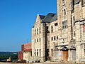
Missouri State Penitentiary
-
Photograph of Jefferson City and its geography from the International Space Station


See also
 In Spanish: Jefferson City para niños
