
Jefferson Davis Parish, Louisiana facts for kids
Quick facts for kids
Jefferson Davis Parish
|
|
|---|---|
| Parish of Jefferson Davis | |

United Methodist Church in Elton.
|
|

Location within the U.S. state of Louisiana
|
|
 Louisiana's location within the U.S. |
|
| Country | |
| State | |
| Founded | January 1, 1913 |
| Named for | Jefferson Davis |
| Seat | Jennings |
| Largest city | Jennings |
| Area | |
| • Total | 659 sq mi (1,710 km2) |
| • Land | 651 sq mi (1,690 km2) |
| • Water | 7.2 sq mi (19 km2) 1.1% |
| Population
(2010)
|
|
| • Total | 31,594 |
| • Estimate
(2018)
|
31,582 |
| • Density | 47.94/sq mi (18.511/km2) |
| Time zone | UTC−6 (Central) |
| • Summer (DST) | UTC−5 (CDT) |
| Congressional district | 3rd |
Jefferson Davis Parish (French: Paroisse de Jefferson Davis) is a parish located in the U.S. state of Louisiana. As of the 2010 census, the population was 31,594. The parish seat is Jennings. Jefferson Davis Parish is named after the president of the Confederacy during the American Civil War, Jefferson Davis. It is located in southwestern Louisiana and forms a part of the Acadiana region.
In 2005, the parish was damaged significantly by Hurricane Rita, which caused much wind damage and flooding in the western part of the parish. The storm also caused Lacassine National Wildlife Refuge to be affected by saltwater intrusion.
Contents
History
Jefferson Davis Parish was one of the last parishes to be organized in the state of Louisiana. It was originally a part of Imperial Calcasieu Parish, which contributed to five other parishes as the population increased in the area. The bill creating Jefferson Davis Parish was passed by the state legislature in 1912 but did not take effect until 1913. Jefferson Davis Parish is part of the large, 22-county Acadiana region of Louisiana, which is influenced by a large Francophone population. It was named after Jefferson Davis, a prominent planter and the President of the Confederate States of America.
Geography
According to the U.S. Census Bureau, the parish has a total area of 659 square miles (1,710 km2), of which 651 square miles (1,690 km2) is land and 7.2 square miles (19 km2) (1.1%) is water.
Jefferson Davis Parish comprises five incorporated towns including Elton, Fenton, Jennings, Lake Arthur, and Welsh. There are also many unincorporated areas that add to the interest and economic structure of the parish including Barnsdall, Buller, China, Coverdale, Edna, Fontenot, Foreman's Hall, Hathaway, Illinois Plant, Lacassine, Lauderdale, Panchoville, Pine Island, Raymond, Roanoke, Silverwood, Thornwell, Topsy, Verret, and Woodlawn. Interstate 10 runs east and west through the center of the parish, providing quick, easy access to local markets. Additionally, the Union Pacific Railroad is centrally located within the parish and the Mermentau River, which connects to the Intracoastal Waterway and has a channel depth of nine feet, provides access to the Port of Mermentau. The Jennings Airport, with a runway length of 5,000 feet (1,500 m), is capable of landing a small jet and is conveniently located next to Interstate 10. Thanks to these and many other attributes within its community, the overall economic outlook for the parish is promising. Jefferson Davis Parish also attracts sportsmen to the Lacassine National Wildlife Refuge.
Adjacent parishes
- Allen Parish (north)
- Evangeline Parish (northeast)
- Acadia Parish (east)
- Vermilion Parish (southeast)
- Cameron Parish (south)
- Calcasieu Parish (west)
- Beauregard Parish (northwest)
Transportation
Major highways
 Interstate 10
 U.S. Highway 90
 U.S. Highway 165
 Louisiana Highway 14
 Louisiana Highway 26
 Louisiana Highway 97
 Louisiana Highway 99
 Louisiana Highway 101
 Louisiana Highway 102
 Louisiana Highway 380
 Louisiana Highway 382
 Louisiana Highway 395
 Louisiana Highway 1130
Airports
- Jennings, (3R7)
- Welsh
|
Jennings, USA
|
|||||||||||||||||||
|---|---|---|---|---|---|---|---|---|---|---|---|---|---|---|---|---|---|---|---|
| Summary | |||||||||||||||||||
| Airport type | Public | ||||||||||||||||||
| Location | Jennings, LA | ||||||||||||||||||
| Elevation AMSL | 23 ft / 7 m | ||||||||||||||||||
| Coordinates | 30°14′33″N 92°40′24″W / 30.24250°N 92.67333°W | ||||||||||||||||||
| Runway | |||||||||||||||||||
|
|||||||||||||||||||
Demographics
| Historical population | |||
|---|---|---|---|
| Census | Pop. | %± | |
| 1920 | 18,999 | — | |
| 1930 | 19,765 | 4.0% | |
| 1940 | 24,191 | 22.4% | |
| 1950 | 26,298 | 8.7% | |
| 1960 | 29,825 | 13.4% | |
| 1970 | 29,554 | −0.9% | |
| 1980 | 32,168 | 8.8% | |
| 1990 | 30,722 | −4.5% | |
| 2000 | 31,435 | 2.3% | |
| 2010 | 31,594 | 0.5% | |
| 2018 (est.) | 31,582 | 0.0% | |
| U.S. Decennial Census 1790-1960 1900-1990 1990-2000 2010-2013 |
|||
2020 census
| Race | Number | Percentage |
|---|---|---|
| White (non-Hispanic) | 24,855 | 77.07% |
| Black or African American (non-Hispanic) | 5,130 | 15.91% |
| Native American | 147 | 0.46% |
| Asian | 100 | 0.31% |
| Pacific Islander | 4 | 0.01% |
| Other/Mixed | 1,280 | 3.97% |
| Hispanic or Latino | 734 | 2.28% |
As of the 2020 United States census, there were 32,250 people, 11,726 households, and 8,149 families residing in the parish.
National Guard
C Company 3-156TH Infantry Battalion resides in Jennings, Louisiana. This unit as part of the 256th IBCT deployed twice to Iraq in 2004-5 and 2010.
Communities

City
Towns
Village
Census-designated places
Unincorporated communities
Education
Jefferson Davis Parish Public Schools operates the schools in the parish.
- Elton Elementary School (Grades PK-5) (Elton)
- Elton High School (Grades 6-12) (Elton)
- Fenton Elementary School (Grades PK-8) (Fenton)
- Hathaway High School (Grades K-12) (Jennings)
- Jennings Elementary School (Grades 3-6) (Jennings)
- Jennings High School (Grades 7-12) (Jennings)
- Lacassine High School (Grades K-12) (Lacassine)
- Lake Arthur Elementary School (Grades PK-6) (Lake Arthur)
- Lake Arthur High School (Grades 7-12) (Lake Arthur)
- James Ward Elementary School (Grades PK-2) (Jennings)
- Welsh Elementary School (Grades PK-5) (Welsh)
- Welsh High School (Grades 8-12) (Welsh)
- Welsh-Roanoke Jr. High School (Grades 6-8) (Roanoke)
Jeff Davis Parish is served by the Roman Catholic Diocese of Lafayette which has one school in the parish:
- Our Lady Immaculate (Grades PK-8) (Jennings)
Additionally, Jeff Davis is served by one unaffiliated private school
- Bethel Christian School is a PreK-12 Christian school located in unincorporated Jefferson Davis Parish, near Jennings.
Jeff Davis Parish is served by one institution of higher education:
- It is in the service area of Sowela Technical Community College. The Morgan Smith campus is located in Jennings.
Notable people
- A.C. Clemons (1921-1992), former Louisiana state senator from 1960-72
- Al Woods (born 1987), current American football player for the Seattle Seahawks of the NFL
- Thomas A. "Tom" Greene (born 1948), former Louisiana state senator from 1992-2000
- Travis Etienne (born 1999), current American football player for the Jacksonville Jaguars of the NFL
- Cleve Francis (born 1945), country music singer, songwriter, and cardiologist
- Monte Ledbetter (1943-2020), former American football player in the NFL
- Eugene John Hebert (1923-1990), priest and Jesuit missionary who famously disappeared in Sri Lanka in 1990 during the Sri Lankan civil war
- Canray Fontenot (1922-1995), American Creole musician
- Charles Mann (born 1944), singer and swamp pop performer and member of the Louisiana Music Hall of Fame
- Jack Doland (1928-1991), former head football coach, athletic director, and president of McNeese State University and Louisiana state senator
Images for kids
-
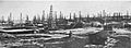
The Jennings Oil Field in 1933
See also
 In Spanish: Parroquia de Jefferson Davis para niños
