
Jellico, Tennessee facts for kids
Quick facts for kids
Jellico, Tennessee
|
|
|---|---|
|
City
|
|

North Main Street
|
|

Location of Jellico in Campbell County, Tennessee.
|
|

Jellico, Tennessee
Location in Tennessee
|
|
| Country | United States |
| State | Tennessee |
| County | Campbell |
| Founded | 1878 |
| Incorporated | 1883 |
| Named for | Jellico coal |
| Area | |
| • Total | 6.29 sq mi (16.29 km2) |
| • Land | 6.22 sq mi (16.11 km2) |
| • Water | 0.07 sq mi (0.19 km2) |
| Elevation | 982 ft (298 m) |
| Population
(2010)
|
|
| • Total | 2,355 |
| • Estimate
(2019)
|
2,165 |
| • Density | 348.13/sq mi (134.42/km2) |
| Time zone | UTC-5 (Eastern (EST)) |
| • Summer (DST) | UTC-4 (EDT) |
| ZIP code |
37762
|
| Area code(s) | 423 |
| FIPS code | 47-38020 |
| GNIS feature ID | 1289336 |
Jellico is a city in Campbell County, Tennessee, United States, on the state border with Kentucky, 58 miles (93 km) by road north of Knoxville. The population was 2,355 at the 2010 census.
Contents
History
The name "Jellico" is a regional corruption of "Angelica", an herb that grows in abundance in the surrounding mountains. The name was first applied to the mountains to the west and to the mountains' main drainage, Jellico Creek, which passes 5 miles (8 km) west of the city of Jellico and empties into the Cumberland River near Williamsburg, Kentucky.

In the early 1880s, a high quality bituminous coal was discovered in the Jellico Mountains, and with the completion of railroad tracks to the area in 1883, coal mines quickly sprang up throughout the area. The city of Jellico was initially founded as "Smithburg" in 1878, but changed its name to "Jellico" in 1883 to capitalize on the growing popularity of Jellico coal. The city was incorporated on March 7, 1883.
Throughout the 1890s and early 1900s, Jellico was one of the most productive coal fields in Kentucky and Tennessee. In 1906, a railroad car packed with dynamite exploded in Jellico, killing eight and destroying part of the town. The town quickly recovered, however, and many of the buildings in the Main Street area date from this period.
In 1971, Indian Mountain State Park was created at the site of a reclaimed strip mine in western Jellico. In 1999, much of North and South Main Street was placed on the National Register of Historic Places as the Jellico Commercial Historic District.
Geography
Jellico is located along the northern border of Tennessee at 36°34′57″N 84°7′50″W / 36.58250°N 84.13056°W (36.582627, -84.130608). The city is situated amidst the Cumberland Mountains in the valley of Elk Creek, which flows north into Kentucky. Jellico spans the western bases and slopes of three steep hills that split the Elk Creek valley from the larger Clear Fork valley to the east. A prominent knob known as Indian Mountain rises nearly 1,000 feet (300 m) above Jellico to the west, and is visible from most of the city. This mountain and an adjacent lake are now home to Indian Mountain State Park. The larger Jellico Mountain dominates the area beyond Indian Mountain to the west, and Pine Mountain dominates the area beyond the Clear Fork Valley to the east.
Jellico is concentrated around the junction of U.S. Route 25W (North Main Street and 5th Street), which connects Jellico to Interstate 75 to the southeast and Corbin, Kentucky, to the north, and Tennessee State Route 297 (South Main Street), which connects Jellico with Huntsville to the southwest. The Tennessee-Kentucky state line forms Jellico's official northern boundary, although houses and businesses associated with the city are on both sides of the border.
According to the United States Census Bureau, the city has a total area of 6.4 square miles (16.5 km2), of which 6.3 square miles (16.3 km2) is land and 0.08 square miles (0.2 km2), or 1.15%, is water.
Demographics
| Historical population | |||
|---|---|---|---|
| Census | Pop. | %± | |
| 1890 | 758 | — | |
| 1900 | 1,283 | 69.3% | |
| 1910 | 1,862 | 45.1% | |
| 1920 | 1,878 | 0.9% | |
| 1930 | 1,530 | −18.5% | |
| 1940 | 1,581 | 3.3% | |
| 1950 | 1,556 | −1.6% | |
| 1960 | 2,210 | 42.0% | |
| 1970 | 2,235 | 1.1% | |
| 1980 | 2,798 | 25.2% | |
| 1990 | 2,447 | −12.5% | |
| 2000 | 2,448 | 0.0% | |
| 2010 | 2,355 | −3.8% | |
| 2019 (est.) | 2,165 | −8.1% | |
| Sources: | |||
2020 census
| Race | Number | Percentage |
|---|---|---|
| White (non-Hispanic) | 2,043 | 94.85% |
| Black or African American (non-Hispanic) | 31 | 1.44% |
| Native American | 6 | 0.28% |
| Asian | 3 | 0.14% |
| Other/Mixed | 62 | 2.88% |
| Hispanic or Latino | 9 | 0.42% |
As of the 2020 United States census, there were 2,154 people, 974 households, and 526 families residing in the city.
Religion
Since 1922, Jellico has been the home of the denominational headquarters for the Church of God Mountain Assembly, a holiness Pentecostal Christian denomination.
Gallery
-
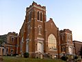
First Baptist Church
-
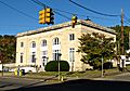
Jellico Post Office
-

Railroad tracks at the state line
-
Grace Moore monument at Veterans Memorial Park


Economy
Jellico Community Hospital is the largest employer with approximately 350 employees.
There are several restaurants, hotels/motels and gas stations located off Jellico's exit of Interstate 75, Exit 160. A Tennessee Welcome Center is located along the interstate just south of the state line.
Notable people
Jellico was the childhood home of Grace Moore, soprano star of opera, musical theatre, and film, and Homer Rodeheaver, hymn-writer, trombonist, and pioneer in the recording of sacred music.
See also
 In Spanish: Jellico (Tennessee) para niños
