
Jindalee, Queensland facts for kids
Quick facts for kids JindaleeBrisbane, Queensland |
|||||||||||||||
|---|---|---|---|---|---|---|---|---|---|---|---|---|---|---|---|
.jpg)
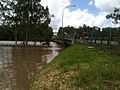
Jindalee Boat Ramp, 2010
|
|||||||||||||||

Jindalee
Location in Queensland
|
|||||||||||||||
| Population | 5,320 (2016 census) | ||||||||||||||
| • Density | 1,716/km2 (4,440/sq mi) | ||||||||||||||
| Postcode(s) | 4074 | ||||||||||||||
| Area | 3.1 km2 (1.2 sq mi) | ||||||||||||||
| Time zone | AEST (UTC+10:00) | ||||||||||||||
| Location | 15.2 km (9 mi) SW of Brisbane GPO | ||||||||||||||
| LGA(s) | City of Brisbane (Jamboree Ward) |
||||||||||||||
| State electorate(s) | Mount Ommaney | ||||||||||||||
| Federal Division(s) | Oxley | ||||||||||||||
|
|||||||||||||||
Jindalee is a south-western residential suburb in the City of Brisbane, Queensland, Australia. In the 2016 census, Jindalee had a population of 5,320 people.
Contents
History
Prior to development the area had been largely used for grazing and dairy farming, however it was developed as part of the Hooker Centenary Project, beginning in 1960. The 8th Australian Scout Jamboree was held in 1967 to 1968 in the south-western corner of Jindalee, in the area which eventually was subdivided and became a suburb in its own right - Jamboree Heights.
The 1974 floods caused large-scale damage to Jindalee, including inundating of many houses, as well as severe damage to the Centenary Bridge. A gravel barge rammed into the upstream side, blocking the floodwaters and raising real fears that the bridge would collapse. The barge was partly sunk using explosives to reduce the floodwater pressure on the bridge. When the floodwater receded the barge was refloated and beached downstream to be cut up for scrap. The damage sustained by the bridge required its partial closure for repairs. For two years after the floods, the bridge was reduced to a single lane. The bridge was duplicated in 1980, providing two lanes each way.
Transport
Jindalee is accessible via the Centenary Highway. Some bus routes service the suburb, namely:
- 450 - City - Riverhills : CityXpress via Cultural Centre, Toowong, Indooroopilly, Jindalee, Mount Ommaney, Middle Park and Westlake (Weekends) (BT)
- 453 - City - Mount Ommaney : CityXpress via Cultural Centre, Toowong, Indooroopilly and Jindalee (Weekdays) (BT)
- 456 - City - Mount Ommaney : Rocket via Milton, Western Freeway and Jindalee (Weekdays - Peak Hours only) (BT)
- 457 - City - Riverhills : City Precincts via Coronation Drive, Western Freeway, Jindalee, Mount Ommaney, Middle Park and Westlake (Weekdays - Peak Hours only) (BT)
- 458 - City - Mount Ommaney : City Precincts via Coronation Drive, Western Freeway and Jindalee. (Weekdays - Peak Hours only) (BT)
Education
Jindalee State School is a government primary (Prep-6) school for boys and girls at 114 Burrendah Road (27°31′47″S 152°56′06″E / 27.5298°S 152.9349°E). In 2017, the school had an enrolment of 820 students with 65 teachers (54 full-time equivalent) and 36 non-teaching staff (22 full-time equivalent). It includes a special education program.
Centenary State High School is a government secondary (7-12) school for boys and girls at 1 Moolanda Street (27°32′19″S 152°56′25″E / 27.5386°S 152.9403°E). In 2017, the school had an enrolment of 1,484 students with 119 teachers (113 full-time equivalent) and 48 non-teaching staff (35 full-time equivalent). It includes a special education program.
Images for kids
-
Brisbane River in flood at Jindalee at the Centenary Bridge, 2011

