
Johnson County, Kansas facts for kids
Quick facts for kids
Johnson County
|
|
|---|---|

Former Johnson County Courthouse in Olathe (2009). It opened in 1952, closed in 2020, then demolished in 2021 after new courthouse was finished.
|
|

Location within the U.S. state of Kansas
|
|
 Kansas's location within the U.S. |
|
| Country | |
| State | |
| Founded | August 25, 1855 |
| Named for | Thomas Johnson |
| Seat | Olathe |
| Largest city | Overland Park |
| Area | |
| • Total | 480 sq mi (1,200 km2) |
| • Land | 473 sq mi (1,230 km2) |
| • Water | 6.5 sq mi (17 km2) 1.4% |
| Population
(2020)
|
|
| • Total | 609,863 |
| • Estimate
(2021)
|
613,219 |
| • Density | 1,289.4/sq mi (497.8/km2) |
| Time zone | UTC−6 (Central) |
| • Summer (DST) | UTC−5 (CDT) |
| Congressional district | 3rd |
Johnson County is a county in the U.S. state of Kansas, on the border with Missouri. As of the 2020 census, the population was 609,863, making it the most populous county in Kansas. Its county seat is Olathe. Largely suburban, the county contains a number of suburbs of Kansas City, Missouri, including Overland Park, the second most populous city in the Kansas City Metropolitan Area. The county is home to the headquarters of Garmin and AMC Theatres.
Contents
History
This was part of the large territory of the Osage people, who occupied lands up to present-day Saint Louis, Missouri. After Indian Removal, the United States government reserved much of this area as Indian territory for a reservation for the Shawnee people, who were relocated from east of the Mississippi River in the upper Midwest.
The Santa Fe Trail and Oregon-California Trail, which pass through nearby Independence, Missouri, also passed through the county. Johnson County was established in 1855 as one of the first counties in the newly organized Kansas Territory; it was named for American missionary Thomas Johnson. The renowned gunfighter Wild Bill Hickok settled for a time in the county, becoming constable of Monticello Township in 1858.
Johnson County was the site of many battles between abolitionists and pro-slavery advocates during the period of Bleeding Kansas, prior to the residents voting on whether slavery would be allowed in the territory. In 1862 during the American Civil War, Confederate guerrillas from nearby Missouri, led by William Quantrill, raided the Johnson County communities of Olathe and Spring Hill. They killed half a dozen men and destroyed numerous homes and businesses.
The county was largely rural until the early 20th century, when housing subdivisions were developed in the northeastern portion of the county adjacent to Kansas City, Missouri. Developer J.C. Nichols spurred the boom in 1914 when he built the Mission Hills Country Club to lure upscale residents who previously had been reluctant to move from Missouri to Kansas. Suburban development continued at a steady pace until the close of World War II.
Following the war, the pace of development exploded, triggered by the return of veterans in need of housing, construction of highways that facilitated commuting from suburbs, and the pent-up demand for new housing. The US Supreme Court ruling in Brown v. Board of Education (1954) ruled that segregation of public schools was unconstitutional. Integration of public schools in Kansas City, Missouri resulted in many white families leaving the inner city, resulting in increased migration to the county for new housing and what were considered higher quality public schools, generally an indicator of higher economic status. From the mid-1980s the pace of growth increased significantly, with the county adding 100,000 residents each decade between the 1990 census and 2010 census.
Geography
According to the U.S. Census Bureau, the county has a total area of 480 square miles (1,200 km2), of which 473 square miles (1,230 km2) is land and 6.5 square miles (17 km2) (1.4%) is water.
Topography
The natural topography of the county consists of gently rolling terrain. The Kansas River forms a portion of the northwest boundary of the county. The elevation generally increases from north to south as the distance from the Kansas and Missouri rivers increases.
Watersheds and streams
The county is drained by the watersheds of the Kansas, Blue, and Marais des Cygnes, all of which are part of the Missouri River watershed. Located in northeastern Kansas, the county receives plentiful rainfall. The county contains numerous small streams, including Kill Creek, Mill Creek, Turkey Creek, Indian Creek, Brush Creek, Tomahawk Creek, the Blue River, Bull Creek and Little Bull Creek.
Kill Creek begins in the southwest portion of the county and flows northward into the Kansas River at DeSoto. Mill Creek begins in the central portion of the county in Olathe, flowing northward it empties into the Kansas River at Shawnee. Turkey Creek and Brush Creek each begin in northeast Johnson County. Turkey Creek flows northeastward into Wyandotte County and joins the Kansas River just before its confluence with the Missouri River at Kaw Point. Brush Creek flows east-northeastward through Prairie Village and Mission Hills, entering Kansas City, Missouri within the median of Ward Parkway and passing the Country Club Plaza before emptying into the Blue River east of the Country Club Plaza and north of Swope Park. Indian Creek begins in the southern portion of Olathe and Tomahawk Creek begins in south Overland Park. Each flows northeastward meeting in Leawood, where the stream retains the name of Indian Creek, just before crossing the state line and entering the Blue River in Kansas City, Missouri. The Blue River begins in rural southern Johnson County and flows north-northeastward through the southeastern portion of the county and crossing the state line just east of the intersection of 151st Street and Kenneth Road in southern Overland Park. The Blue River flows through southern and eastern Kansas City before joining the Missouri River. Bull Creek and Little Bull Creek begin in rural southwestern Johnson County and flow southward where they enter Hillsdale Lake before continuing into Miami County, eventually joining the Marais des Cygnes at Paola.
Flora and fauna
The county consists primarily of prairie grassland with corridors of forested areas along streams and rivers.
Adjacent counties
- Wyandotte County (north)
- Jackson County, Missouri (east)
- Cass County, Missouri (southeast)
- Miami County (south)
- Franklin County (southwest)
- Douglas County (west)
- Leavenworth County (northwest)
Demographics
| Historical population | |||
|---|---|---|---|
| Census | Pop. | %± | |
| 1860 | 4,364 | — | |
| 1870 | 13,684 | 213.6% | |
| 1880 | 16,853 | 23.2% | |
| 1890 | 17,385 | 3.2% | |
| 1900 | 18,104 | 4.1% | |
| 1910 | 18,288 | 1.0% | |
| 1920 | 18,314 | 0.1% | |
| 1930 | 21,179 | 15.6% | |
| 1940 | 33,327 | 57.4% | |
| 1950 | 62,783 | 88.4% | |
| 1960 | 143,792 | 129.0% | |
| 1970 | 220,073 | 53.0% | |
| 1980 | 270,269 | 22.8% | |
| 1990 | 357,048 | 32.1% | |
| 2000 | 451,086 | 26.3% | |
| 2010 | 544,179 | 20.6% | |
| 2020 | 609,863 | 12.1% | |
| 2021 (est.) | 613,219 | 12.7% | |
| U.S. Decennial Census 1790-1960 1900-1990 1990-2000 2010-2020 |
|||

Johnson County (county code JO) is included in the Kansas City metropolitan area. The county has the highest median household income at $81,121 in 2017 and the highest per-capita income in Kansas, with the 19th highest median household income in 2000 and the 46th highest per-capita income in 2005. In 2010, Money magazine, in its list of the '100 Best Cities in the United States' in which to live, ranked Overland Park 7th (ranked 6th in 2006 and 9th in 2008) and Shawnee 17th (ranked 39th in 2008). In 2008 the same magazine also ranked Olathe 11th.
2010
As of the 2010 census, there were 544,179 people, 210,278 households, and 143,509 families residing in the county. The population density was 1,150 people per square mile (365/km2). There were 226,571 housing units at an average density of 381 per square mile (147/km2). The racial makeup of the county was 86.0% White, 4.2% Asian, 4.3% Black or African American, 0.4% Native American, 0.01% Pacific Islander, 1.55% from other races, and 2.5% from two or more races. Hispanic or Latino of any race were 7.2% of the population. 30.6% identified as of German, 16.8% Irish, 13.6% English and 5.7% American ancestry according to the 2010 census.
There were 210,278 households, out of which 34.6% had children under the age of 18 living with them, 56.1% were married couples living together, 8.4% had a female householder with no husband present, and 31.8% were non-families. 25.9% of all households were made up of individuals, and 7.8% had someone living alone who was 65 years of age or older. The average household size was 2.51 and the average family size was 3.05.
In the county, the population was spread out, with 26.3% under the age of 18, 7.60% from 18 to 24, 32.80% from 25 to 44, 22.50% from 45 to 64, and 10.9% who were 65 years of age or older. The median age was 36.4 years. 48.8% of the population were males and 51.2% of the population were females.
The median income for a household in the county was $73,733, and the median income for a family was $90,380. Males had a median income of $61,346 versus $43,785 for females. The per capita income for the county was $37,882. About 3.6% of families and 5.5% of the population were below the poverty line, including 7.1% of those under age 18 and 4.9% of those age 65 or over.
2000
As of the census2 of 2000, there were 451,086 people, 174,570 households, and 121,675 families residing in the county. The population density was 365/km2 (946/mi2). There were 181,612 housing units at an average density of 147/km2 (381/mi2). The racial makeup of the county was 91.11% White, 2.61% Black or African American, 0.33% Native American, 2.83% Asian, 0.03% Pacific Islander, 1.55% from other races, and 1.54% from two or more races. 3.98% of the population were Hispanic or Latino of any race.
There were 174,570 households, out of which 36.00% had children under the age of 18 living with them, 59.20% were married couples living together, 7.80% had a female householder with no husband present, and 30.30% were non-families. 24.50% of all households were made up of individuals, and 6.70% had someone living alone who was 65 years of age or older. The average household size was 2.56 and the average family size was 3.09.
In the county the population was spread out, with 27.10% under the age of 18, 7.60% from 18 to 24, 32.80% from 25 to 44, 22.50% from 45 to 64, and 10.00% who were 65 years of age or older. The median age was 35 years. For every 100 females there were 95.50 males. For every 100 females age 18 and over, there were 92.00 males.
The median income for a household in the county was $61,455, and the median income for a family was $72,987. Males had a median income of $49,790 versus $32,145 for females. The per capita income for the county was $30,919. 3.40% of the population and 2.10% of families were below the poverty line. Out of the total population, 3.30% of those under the age of 18 and 3.60% of those 65 and older were living below the poverty line.
Transportation
Johnson County has a grid network through most of the county, with a road every mile. The grid has facilitated rapid growth and easy access. Interstate 435 runs through much of the county, and serves as a developmental "border" in the northbound–southbound portion. The westbound–eastbound part of I-435 divides the county into a northern and southern section. The northern section is older, while the southern portion is the fastest-growing area in Johnson County, containing a massive volume of new homes.
The Johnson County numbered street grid generally begins at 47th Street, the Wyandotte County line (the lowest numbered street is 40th Street in Bonner Springs), and is a continuation of the adjacent Kansas City, Missouri, street grid. The grid continues to 215th Street, and into Miami County (with somewhat different named roads) to 407th Street at the Miami-Linn county line, with most suburban development ending around 167th Street. Named streets in the grid run from State Line Road (1900 West) to County Line Road (40699 West) at the Douglas County line. A portion of the grid extends north from Westwood into the Rosedale area in Kansas City, Kansas.
Another principal highway running through the area is Interstate 35, which runs diagonally through the county, entering it near Downtown Kansas City, and continuing through Olathe and Gardner. Outside the county, it eventually leads to Duluth, Minnesota in the north and the US–Mexico border in the south. U.S. 69 also serves Johnson County, entering from Wyandotte County at the south end of Interstate 635. Much of U.S. 69 within the county is freeway; this freeway eventually heads south and connects to Fort Scott and the rest of southeast Kansas.
Major highways
 I-35 Southwest corner with Franklin County northeast through Edgerton, Gardner, Olathe, Lenexa, Overland Park, and Merriam to the northeast corner with downtown Kansas City
 I-435 Northern border with Wyandotte County south through Shawnee and Lenexa to K-10 then east through Overland Park and Leawood to the Missouri border
 I-635 Starts in Johnson County at I-35 and enters Wyandotte County/Kansas City, KS less than 1000 feet later.
 US-50 Southwest corner with Franklin County northeast through Edgerton, Gardner, Olathe, Lenexa, Overland Park, and Merriam to the northeast corner with downtown Kansas City
 US-56 Southwest border with Douglas County east through Edgerton and Gardner to I-35
 US-69 Southeast border with Miami County north through Stilwell and Overland Park past I-435 to I-35
 US-169 Southern border with Miami County. Joins with I-35 in Olathe.
 K-7 Southern border with Miami County north through Spring Hill, Olathe, Lenexa, and Shawnee to Wyandotte County
 K-10 Western border with Douglas County east through De Soto, Lenexa, and Olathe to I-435
Other major roads
- Shawnee Mission Parkway – Interchange with K-7 in Shawnee east through Merriam, Mission, Fairway, and Mission Woods then joining up with Ward Parkway in Missouri
- Metcalf Avenue – Runs parallel with US-69 from Miami County north through Stilwell and Overland Park past I-435 and Shawnee Mission Parkway to join up with I-635 and I-35 in Wyandotte County
- Quivira Road – About 1⁄2 mile (0.80 km) mile north of Oak Grove Road in Kansas City, Kansas (as South 63rd Street, becomes Quivira Road at County Line Road/West 47th Street) to 183rd Street, with a second, rural southern section beginning at 187th Street and continuing to 239th Street in Miami County. The northern section is a major thoroughfare from Johnson Drive to 143rd Street, passing by Oak Park Mall at 95th Street and Johnson County Community College at College Boulevard.
- College Boulevard (formerly 111th Street, west of Tomahawk Creek Parkway) – State Line Road at Red Bridge Road in Leawood to Cedar Niles Parkway in Olathe. Takes its name from Johnson County Community College, at Quivira Road.
- 135th Street / Santa Fe Street – Interchange with State Line Road at MO-150 in south Kansas City, Missouri, west to Spoon Creek Road. Within the city limits of Olathe, 135th Street is legally known as Santa Fe Street. The numbering system changes to reflect the change in street name.
- 175/179th Street – Interchange with US-56 and I-35 as 175th St. east to Pflumm Rd. where it turns southeast to become 179th street then east to US-69 and Metcalf Ave.
- 199th Street – Intersection with US-56 in Edgerton east through Spring Hill and Stilwell to the Missouri border
- 119th Street – Major street that connects Olathe, Overland Park, and I-35 to each other.
- 151st Street – Major street that connects I-35 with U.S. 69 skirting the Johnson County Executive Airport and The Great Plains Mall.
- Lexington Ave/83rd Street/87th Street Parkway - Major street that runs from Douglas County through De Soto, Lenexa and Overland Park.
- 95th Street. Runs east and west from State line into Missouri, (east side) past 7 highway in Lenexa. (West side)
- 75th Street. Runs East and west from State line into Missouri, (east side) to Shawnee Mission Park. (west side).
- 159th Street. Runs east and west from Kenneth Road (east) into Missouri and to Baldwin City (West). Blue Valley High School and Blue Valley West High are located off 159th, as well as the New Century AirCenter in Gardner.
Airports
Johnson County is home to three general aviation airports:
- Johnson County Executive Airport
- New Century AirCenter
- Hillside Airport
The closest airport with airline service is Kansas City International Airport in Platte County, Missouri
Public transit
Johnson County Transit is the public transit operator.
Communities

Cities
- Bonner Springs (partly in Wyandotte County and Leavenworth County)
- De Soto (partly in Leavenworth County)
- Edgerton
- Fairway* Gardner
- Lenexa* Leawood* Lake Quivira* (partly in Wyandotte County)
- Merriam* Mission* Mission Hills* Mission Woods* Overland Park* Olathe
- Prairie Village* Roeland Park* Shawnee* Spring Hill (partly in Miami County)
- Westwood* Westwood Hills
*Cities included in Shawnee Mission, a postal designation encompassing cities or regions thereof in northeastern Johnson County, headquarter post office located in Mission.
Unincorporated communities
Townships
Johnson County was originally divided into nine townships, two of which have since been eliminated by the annexation of all their territory into independent municipalities. All of the cities are considered governmentally independent and are excluded from the census figures for the townships. In the following table, the population center is the largest city (or cities) included in that township's population total, if it is of a significant size.
| Township | FIPS | Population center |
Population | Population density /km² (/sq mi) |
Land area km² (sq mi) |
Water area km² (sq mi) |
Water % | Geographic coordinates |
|---|---|---|---|---|---|---|---|---|
| Aubry | 03225 | 5,440 | 43 (112) | 126 (49) | 0 (0) | 0.31% | 38°46′48″N 94°41′4″W / 38.78000°N 94.68444°W | |
| Gardner | 25450 | 2,143 | 21 (55) | 102 (39) | 1 (0) | 0.53% | 38°49′7″N 94°54′31″W / 38.81861°N 94.90861°W | |
| Lexington | 39800 | De Soto | 3,712 | 10 (25) | 135 (52) | 2 (1) | 1.79% | 38°55′0″N 95°0′13″W / 38.91667°N 95.00361°W |
| McCamish | 43625 | 878 | 8 (20) | 112 (43) | 0 (0) | 0.34% | 38°47′22″N 94°59′48″W / 38.78944°N 94.99667°W | |
| Monticello (defunct) | 47950 | 0 | 0 (0) | 0 (0) | 0 (0) | 0% | 39°1′59″N 94°47′57″W / 39.03306°N 94.79917°W | |
| Olathe | 52600 | 1,187 | 27 (70) | 44 (17) | 0 (0) | 0.04% | 38°54′21″N 94°49′18″W / 38.90583°N 94.82167°W | |
| Oxford | 53825 | 2,020 | 121 (313) | 17 (6) | 0 (0) | 1.54% | 38°49′58″N 94°40′54″W / 38.83278°N 94.68167°W | |
| Shawnee (defunct) | 64525 | 0 | 0 (0) | 0 (0) | 0 (0) | 0% | 39°1′51″N 94°47′47″W / 39.03083°N 94.79639°W | |
| Spring Hill | 67650 | 2,059 | 29 (76) | 70 (27) | 0 (0) | 0.30% | 38°46′35″N 94°48′55″W / 38.77639°N 94.81528°W | |
| Sources: | ||||||||
In popular culture
- Johnson County was the setting of the TV show Married to the Kellys.
- Overland Park is the setting for The United States of Tara.
- Blue Valley Northwest High School students were featured in the series High School Confidential, centered in south Johnson County.
- Mission Hills is the setting for The ABC Family show Switched at Birth
- In 1990 Michael Landon filmed part of the TV Movie "Where Pigeons Go to Die" at the corner of 95th and Metcalf (Overland Park, KS) in front of the Sprint buildings.
Education
.jpg)
According to the 2010 Census Bureau, the education attainment of the population 25 years and over: 95.6% high school graduate or higher, 51.1% bachelor's degree or higher, and 17.9% graduate or professional degree.
The Johnson County Library has 13 branches.
Unified school districts
- Blue Valley USD 229
- Spring Hill USD 230
- Gardner-Edgerton USD 231
- De Soto USD 232
- Olathe USD 233
- Shawnee Mission USD 512
Colleges and universities
- Johnson County Community College
- University of Kansas Edwards Campus
- Kansas State University, Olathe Campus
- Kansas Christian College (Overland Park)
- MidAmerica Nazarene University
- Baker University, Overland Park Campus
- Ottawa University, Overland Park Campus
- Park University, Lenexa Campus
Images for kids
-
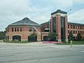
Olathe City Hall (2009)

See also
 In Spanish: Condado de Johnson (Kansas) para niños
