Kagaru, Queensland facts for kids
Quick facts for kids KagaruQueensland |
|||||||||||||||
|---|---|---|---|---|---|---|---|---|---|---|---|---|---|---|---|

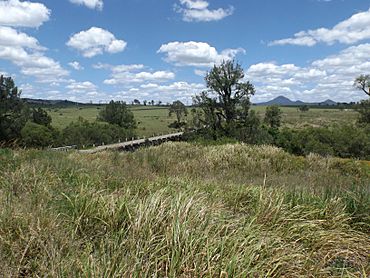
Teviot Brook crossing, 2016
|
|||||||||||||||
| Population | 13 (2016 census) | ||||||||||||||
| • Density | 0.448/km2 (1.16/sq mi) | ||||||||||||||
| Established | 1997 | ||||||||||||||
| Postcode(s) | 4285 | ||||||||||||||
| Area | 29.0 km2 (11.2 sq mi) | ||||||||||||||
| Time zone | AEST (UTC+10:00) | ||||||||||||||
| Location |
|
||||||||||||||
| LGA(s) |
|
||||||||||||||
| State electorate(s) |
|
||||||||||||||
| Federal Division(s) | Wright | ||||||||||||||
|
|||||||||||||||
Kagaru is a rural locality split between Scenic Rim Region and City of Logan , Queensland, Australia. In the 2016 census, Kagaru had a population of 13 people.
Geography
Kagaru's eastern border is marked by the Sydney–Brisbane rail corridor, the Logan River and Teviot Brook. There is very little development in the area.
History
In the 1930s, a railway station in the area was named Kagaru, an Aboriginal word for the blue-winged kookaburra. In 1996, the locality was formally bounded and took the name of the railway station.
Formerly in the Shire of Beaudesert, Kagaru became split between Logan City and Scenic Rim Region following the local government amalgamations in March 2008.

All content from Kiddle encyclopedia articles (including the article images and facts) can be freely used under Attribution-ShareAlike license, unless stated otherwise. Cite this article:
Kagaru, Queensland Facts for Kids. Kiddle Encyclopedia.

