
Kameyama, Mie facts for kids
Quick facts for kids
Kameyama
亀山市
|
|||
|---|---|---|---|

Kameyama City Hall in Honmaru area
|
|||
|
|||

Location of Kameyama in Mie Prefecture
|
|||

Kameyama
Location in Japan
|
|||
| Country | Japan | ||
| Region | Kansai | ||
| Prefecture | Mie Prefecture | ||
| Area | |||
| • Total | 190.91 km2 (73.71 sq mi) | ||
| Population
(November 2012)
|
|||
| • Total | 50,230 | ||
| • Density | 263/km2 (680/sq mi) | ||
| Time zone | UTC+9 (Japan Standard Time) | ||
| - Tree | Cryptomeria | ||
| - Flower | Japanese iris | ||
| Phone number | 0595-82-1111 | ||
| Address | 577 Honmaru-cho, Kameyama-shi, Mie-ken 519-0195 | ||


Kameyama (亀山市, Kameyama-shi) is a Japanese city in Mie Prefecture on the island of Honshū.
Contents
History
Main page: List of the 53 Stations of the Tōkaidō
In the Edo period, Kameyama-juku, Seki-juku and Sakanoshita-juku were the 46th, 47th and 48th of the 53 shogunate-maintained waystations (shuku-eki) along the Tōkaidō road which connected Edo and Kyoto. All three Tōkaidō rest stops are within the boundaries of modern Numazu.
Gallery
-
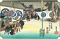
Seki rest stop by Hiroshige, c. 1830s
-
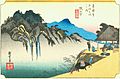
Sakanoshita rest stop by Hiroshige, c. 1830s
-
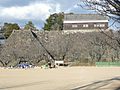
Stone wall at former Kameyama Castle
-
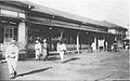
Kameyama railway station, early Taishō period (1912–1926)


Related pages
Images for kids
-
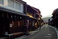
Seki-juku (Tōkaidō)

See also
 In Spanish: Kameyama (Mie) para niños

All content from Kiddle encyclopedia articles (including the article images and facts) can be freely used under Attribution-ShareAlike license, unless stated otherwise. Cite this article:
Kameyama, Mie Facts for Kids. Kiddle Encyclopedia.