Kangarilla, South Australia facts for kids
Quick facts for kids KangarillaSouth Australia |
|||||||||||||||
|---|---|---|---|---|---|---|---|---|---|---|---|---|---|---|---|

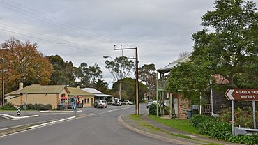
Main street of Kangarilla
|
|||||||||||||||
| Population | 896 (2016 census) | ||||||||||||||
| Postcode(s) | 5157 | ||||||||||||||
| Elevation | 195 m (640 ft) | ||||||||||||||
| Location | 41 km (25 mi) from Adelaide | ||||||||||||||
| LGA(s) | City of Onkaparinga | ||||||||||||||
| Region | Southern Adelaide | ||||||||||||||
| County | Adelaide | ||||||||||||||
| Federal Division(s) | Division of Mayo | ||||||||||||||
|
|||||||||||||||
Kangarilla is a small rural town and locality around 33 km (21 mi) from Adelaide city centre, in South Australia. The area, formerly inhabited by Kaurna people, was settled by Europeans in 1840, not long after the British colonisation of South Australia. Today it lies within the City of Onkaparinga local government area, and has postcode 5157. At the 2016 census, Kangarilla had a population of 896.
History
The land around Kangarilla was first settled in around 1840, with wheat and vineyards the main produce. A town was founded in 1849 by John Bottrill, and properly surveyed in 1860. The name was changed regularly in the early days; originally called Scaldwell, then Eyre Flat, the name "Kangarilla" (a word from the local Kaurna language meaning "place of two springs") was settled upon in 1862.
Description and Demographics
Kangarilla lies around 33 km (21 mi) from Adelaide city centre, close to the Adelaide Hills and at the northern end of the Fleurieu Peninsula. It is regarded as a township in the Australian sense (a small town), although technically also a suburb or locality. It is physically separated from nearby townships by areas of agriculture and viticulture, notably the McLaren Vale area, about a 15-minute drive away.
At the 2016 census, Kangarilla had a population of 896.
Images for kids


