
Kareli Municipality facts for kids
Quick facts for kids
Kareli Municipality
ქარელის მუნიციპალიტეტი
|
|||
|---|---|---|---|
|
Municipality
|
|||
|
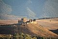
Mdzovreti fortress
|
|||
|
|||

Location of Kareli Municipality in Georgia
|
|||
| Country | |||
| Region | Shida Kartli | ||
| Capital | Kareli | ||
| various | 1 town, 1 townlet and 73 villages | ||
| Area | |||
| • Total | 687.9 km2 (265.6 sq mi) | ||
| Population
(2014)
|
|||
| • Total | 41,316 | ||
| • Density | 60.061/km2 (155.557/sq mi) | ||
| Time zone | UTC+4 | ||
| Website | Official site of shida kartli region: http://www.shidakartli.gov.ge/index.php?cat=77&par=6 | ||


.jpg)
Kareli (Georgian: ქარელის მუნიციპალიტეტი, Karelis municiṗaliṫeṫi) is a district of Georgia, in the region of Shida Kartli. Some northern territories of the district are part of the self-proclaimed republic of South Ossetia and have not been under control of the Georgian government since 1992. Located in the central part of Georgia on the Shida Kartli plain. The municipality is bordered on the east by Gori, on the west by Khashuri, and on the south by Borjomi. Area of the municipality - 687.9 km2 Population - 41 316 people. There are 35 state public schools and 1 private school-gymnasium, a secondary vocational school, 1 central library, a cultural center and a museum of local lore in Kareli municipality.
Economy
In Kareli municipality there are mainly fields with investment potential: processing industry and agriculture. Agar sugar factory and food industry enterprises are located in Kareli municipality. The leading fields of agriculture are: fruit growing, horticulture, horticulture-horticulture, viticulture, animal husbandry and others. The main highway and highways of the Transcaucasian Railway pass here.
Images for kids
-
Samtsevrisi Castle

See also
 In Spanish: Municipio de Kareli para niños
