Kenilworth, New Jersey facts for kids
Quick facts for kids
Kenilworth, New Jersey
|
|
|---|---|
|
Borough
|
|
| Borough of Kenilworth | |
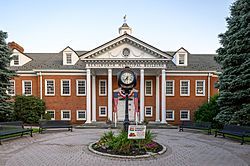
Kenilworth Municipal Building
|
|
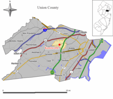
Map of Kenilworth in Union County. Inset: Location of Union County highlighted in the State of New Jersey.
|
|
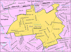
Census Bureau map of Kenilworth, New Jersey
|
|
| Country | |
| State | |
| County | |
| Incorporated | May 13, 1907 |
| Named for | Kenilworth Castle |
| Government | |
| • Type | Borough |
| • Body | Borough Council |
| Area | |
| • Total | 2.15 sq mi (5.57 km2) |
| • Land | 2.15 sq mi (5.56 km2) |
| • Water | <0.01 sq mi (0.01 km2) 0.19% |
| Area rank | 398th of 565 in state 17th of 21 in county |
| Elevation | 115 ft (35 m) |
| Population | |
| • Total | 7,914 |
| • Estimate
(2019)
|
8,191 |
| • Rank | 291st of 566 in state 17th of 21 in county |
| • Density | 3,668.3/sq mi (1,416.3/km2) |
| • Density rank | 173rd of 566 in state 14th of 21 in county |
| Time zone | UTC−05:00 (Eastern (EST)) |
| • Summer (DST) | UTC−04:00 (Eastern (EDT)) |
| ZIP Code |
07033
|
| Area code(s) | 908 |
| FIPS code | 3403936690 |
| GNIS feature ID | 0885267 |
| Website | |
Kenilworth is a borough in Union County, New Jersey, United States. As of the 2010 United States Census, the borough's population was 7,914, reflecting an increase of 239 (+3.1%) from the 7,675 counted in the 2000 Census, which had in turn increased by 101 (+1.3%) from the 7,574 counted in the 1990 Census.
Kenilworth was incorporated as a borough by an act of the New Jersey Legislature on May 13, 1907, from portions of Cranford and Union Township, based on the results of a referendum held on June 18, 1907.
Contents
History
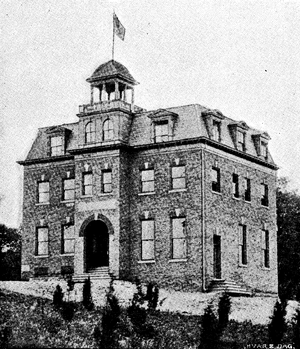
In the late 1890s, the New Orange Industrial Association purchased land in Cranford and Union that was subdivided into building lots. The firm brought in several large industries and lured Upsala College from Brooklyn with an offer of cash and free land for its campus.
Because New Orange was often confused with one of The Oranges in Essex County, the name "Kenilworth" was chosen when the borough was incorporated in 1907. The name Kenilworth came from a literary society (The Kenilworth Club) which the businessmen belonged to. The Kenilworth Club was named in honor of the novel Kenilworth written in 1821 by Sir Walter Scott. The novel refers to England's Kenilworth Castle located in Kenilworth, England.
Geography
According to the United States Census Bureau, the borough had a total area of 2.161 square miles (5.598 km2), including 2.157 square miles (5.588 km2) of land and 0.004 square miles (0.010 km2) of water (0.19%).
The borough is bordered to the north and east by Union Township, to the southeast by Roselle Park, to the southwest by Cranford, and to the northwest by Springfield Township.
Demographics
| Historical population | |||
|---|---|---|---|
| Census | Pop. | %± | |
| 1910 | 779 | — | |
| 1920 | 1,312 | 68.4% | |
| 1930 | 2,243 | 71.0% | |
| 1940 | 2,451 | 9.3% | |
| 1950 | 4,922 | 100.8% | |
| 1960 | 8,379 | 70.2% | |
| 1970 | 9,165 | 9.4% | |
| 1980 | 8,221 | −10.3% | |
| 1990 | 7,574 | −7.9% | |
| 2000 | 7,675 | 1.3% | |
| 2010 | 7,914 | 3.1% | |
| 2019 (est.) | 8,191 | 3.5% | |
| Population sources: 1910-1920 1910 1910-1930 1930-1990 2000 2010 |
|||
Census 2010
As of the census of 2010, there were 7,914 people, 2,841 households, and 2,102 families residing in the borough. The population density was 3,668.3 per square mile (1,416.3/km2). There were 2,924 housing units at an average density of 1,355.3 per square mile (523.3/km2)*. The racial makeup of the borough was 88.07% (6,970) White, 2.91% (230) Black or African American, 0.14% (11) Native American, 3.84% (304) Asian, 0.03% (2) Pacific Islander, 3.31% (262) from other races, and 1.71% (135) from two or more races. [[Hispanic (U.S. Census)|Hispanic or Latino of any race were 15.52% (1,228) of the population.
There were 2,841 households out of which 31.6% had children under the age of 18 living with them, 55.2% were married couples living together, 13.3% had a female householder with no husband present, and 26.0% were non-families. 21.2% of all households were made up of individuals, and 10.5% had someone living alone who was 65 years of age or older. The average household size was 2.78 and the average family size was 3.26.
In the borough, the population was spread out with 21.8% under the age of 18, 7.8% from 18 to 24, 26.7% from 25 to 44, 28.1% from 45 to 64, and 15.6% who were 65 years of age or older. The median age was 40.9 years. For every 100 females there were 93.9 males. For every 100 females ages 18 and old there were 90.0 males.
The Census Bureau's 2006-2010 American Community Survey showed that (in 2010 inflation-adjusted dollars) median household income was $76,500 (with a margin of error of +/- $8,607) and the median family income was $84,097 (+/- $6,220). Males had a median income of $58,327 (+/- $7,147) versus $42,589 (+/- $5,730) for females. The per capita income for the borough was $31,959 (+/- $2,853). About 4.0% of families and 5.7% of the population were below the poverty line, including 11.6% of those under age 18 and 4.5% of those age 65 or over.
Census 2000
As of the 2000 United States Census there were 7,675 people, 2,854 households, and 2,117 families residing in the borough. The population density was 3,584.9 people per square mile (1,384.7/km2). There were 2,926 housing units at an average density of 1,366.7 per square mile (527.9/km2). The racial makeup of the borough was 92.30% White, 2.30% African American, 0.25% Native American, 2.88% Asian, 1.80% from other races, and 1.38% from two or more races. Hispanic or Latino residents of any race were 8.64% of the population.
There were 2,854 households, out of which 28.6% had children under the age of 18 living with them, 58.4% were married couples living together, 11.9% had a female householder with no husband present, and 25.8% were non-families. 21.4% of all households were made up of individuals, and 11.0% had someone living alone who was 65 years of age or older. The average household size was 2.69 and the average family size was 3.15.
In the borough the population was spread out, with 20.8% under the age of 18, 6.9% from 18 to 24, 30.8% from 25 to 44, 23.3% from 45 to 64, and 18.2% who were 65 years of age or older. The median age was 40 years. For every 100 females, there were 94.2 males. For every 100 females age 18 and over, there were 90.7 males.
The median income for a household in the borough was $59,929, and the median income for a family was $66,500. Males had a median income of $40,808 versus $34,698 for females. The per capita income for the borough was $24,343. About 1.9% of families and 2.0% of the population were below the poverty line, including 2.2% of those under age 18 and 3.2% of those age 65 or over.
Arts and culture
Since 2004, the Hudson Shakespeare Company has brought their Shakespeare in the Park programs to the Kenilworth Library known as the "Bard on the Boulevard". The Friends of the Kenilworth Library, with the assistance of a grant from the Union County Office of Cultural Affairs, sponsor these events.
Transportation
Roads and highways
As of May 2010[update], the borough had a total of 29.62 miles (47.67 km) of roadways, of which 24.22 miles (38.98 km) were maintained by the municipality, 4.00 miles (6.44 km) by Union County and 0.04 miles (0.064 km) by the New Jersey Department of Transportation.
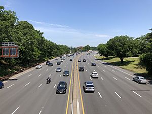
Kenilworth is served by two county routes, County Route 509 (CR 509) and CR 617. CR 509 (Boulevard) runs west–east through the borough, connecting it to Cranford, Springfield and Westfield in one direction and Union and Roselle Park in the other. CR 617 (Michigan Avenue) runs north–south, connecting Union and U.S. Route 22 at its north end to Roselle Park and Route 28 at its south end. The Garden State Parkway cuts northeast–southwest through the town, with Interchange 138 at CR 509 serving much of the town's long-distance travelers.
Public transportation
NJ Transit provides bus service between Kenilworth and the Port Authority Bus Terminal in Midtown Manhattan in New York City and to New Jersey points, including the city of Elizabeth and nearby Union County College in Cranford. Local service is available on the 58 route, which is a direct descendant of Kenilworth's trolley route in the early 20th century.
The closest NJ Transit rail station is Roselle Park, less than a mile from the Kenilworth border and offering direct service into New York City's Penn Station on the Raritan Valley Line.
The Rahway Valley Railroad passed through the community but is currently out of service, the final train on the line having left the borough in April 1992. Originally established as the New York and New Orange Railroad, the line stretched 11.8 miles (19.0 km) from Aldene (now known as Roselle Park) to Summit. The headquarters of the railroad were located in Kenilworth, originally in Kenilworth's Victorian-style station house until that was severely damaged in a 1974 fire, after which railroad offices were moved into a trailer and then an unused railroad club car.
Newark Liberty International Airport is approximately 9 miles (14 km) from Kenilworth.
Economy
Companies headquartered in Kenilworth include Maingear, a privately held computer manufacturer specializing in custom gaming computers, desktops, custom laptops, media center computers and workstations, all of which are manufactured in the United States.
Merck & Co. announced plans in October 2013 to move its global headquarters from the Whitehouse Station of Readington Township, New Jersey to Kenilworth, on a site that the company had previously used as a manufacturing facility, with the relocation to be completed by 2015. The campus had been used as the global headquarters for Schering-Plough, which was acquired by Merck in 2009. In April 2020, Merck announced that it would be moving its global headquarters from Kenilworth to Rahway, New Jersey by the end of 2023.
Education
The Kenilworth Public Schools serves students in pre-kindergarten through twelfth grade. As of the 2018–19 school year, the district, comprised of two schools, had an enrollment of 1,466 students and 126.0 classroom teachers (on an FTE basis), for a student–teacher ratio of 11.6:1. Schools in the district (with 2018–19 enrollment data from the National Center for Education Statistics) are Warren G. Harding Elementary School with 690 students in grades PreK-6 and David Brearley Middle School / David Brearley High School with 757 students in grades 7-12.
Students from Winfield Township attend David Brearley High School as part of a sending/receiving relationship with the Winfield Township School District.
Kenilworth is home to a Roman Catholic elementary school at St. Theresa's, which was founded in 1954 and serves students in pre-school through eighth grade through the Salesians of Don Bosco.
Notable people
People who were born in, residents of, or otherwise closely associated with Kenilworth include:
- Tashawn Bower (born 1995), defensive end who has played in the NFL for the Minnesota Vikings.
- John P. Gallagher (1932–2011), politician who served in the New Jersey Senate from the 13th Legislative District from 1982 to 1984.
- Sheldon Karlin (1950-2000), distance runner who won the New York City Marathon in 1972.
- Tony Siragusa (born 1967), Indianapolis Colts and Baltimore Ravens defensive tackle, was born and raised in Kenilworth and starred in football and wrestling for David Brearley High School.
See also
 In Spanish: Kenilworth (Nueva Jersey) para niños


