
Kenmare, North Dakota facts for kids
Quick facts for kids
Kenmare, North Dakota
|
|
|---|---|
| Nickname(s):
Kenmare Honkers
|
|

Location of Kenmare, North Dakota
|
|
| Country | United States |
| State | North Dakota |
| County | Ward |
| Area | |
| • Total | 1.34 sq mi (3.47 km2) |
| • Land | 1.34 sq mi (3.47 km2) |
| • Water | 0.00 sq mi (0.00 km2) |
| Elevation | 1,890 ft (576 m) |
| Population
(2010)
|
|
| • Total | 1,096 |
| • Estimate
(2019)
|
1,021 |
| • Density | 761.37/sq mi (294.00/km2) |
| Time zone | UTC−6 (Central (CST)) |
| • Summer (DST) | UTC−5 (CDT) |
| ZIP code |
58746
|
| Area code(s) | 701 |
| FIPS code | 38-42020 |
| GNIS feature ID | 1029729 |
| Highways | US 52, ND 28 |
| Website | KenmareND.com |
Kenmare is a city in Ward County, North Dakota, United States. The population was 1,096 at the 2010 census. Kenmare is part of the Minot Micropolitan Statistical Area.
History
Kenmare was platted in 1897. The city most likely was named after Kenmare, in Ireland. A post office has been in operation at Kenmare since 1897. When proposals were drawn up to partition the old 'Imperial' Ward County (then the state's largest county) in 1908, the groups involved with Burke and Renville Counties declined to include Kenmare as it was larger than Bowbells or Mohall (the cities chosen as the proposed county seats) and would likely have prevailed in a county seat battle. Another proposal would have created Lake County out of this portion of Imperial Ward County, with Kenmare as its seat.
Geography
Kenmare is located at 48°40′30″N 102°4′43″W / 48.67500°N 102.07861°W (48.675015, −102.078709). According to the United States Census Bureau, the city has a total area of 1.24 square miles (3.21 km2), all of it land. '
Demographics
| Historical population | |||
|---|---|---|---|
| Census | Pop. | %± | |
| 1910 | 1,437 | — | |
| 1920 | 1,446 | 0.6% | |
| 1930 | 1,494 | 3.3% | |
| 1940 | 1,528 | 2.3% | |
| 1950 | 1,712 | 12.0% | |
| 1960 | 1,696 | −0.9% | |
| 1970 | 1,515 | −10.7% | |
| 1980 | 1,456 | −3.9% | |
| 1990 | 1,214 | −16.6% | |
| 2000 | 1,081 | −11.0% | |
| 2010 | 1,096 | 1.4% | |
| 2019 (est.) | 1,021 | −6.8% | |
| U.S. Decennial Census 2018 Estimate |
|||
2010 census
As of the census of 2010, there were 1,096 people, 480 households, and 281 families living in the city. The population density was 883.9 inhabitants per square mile (341.3/km2). There were 558 housing units at an average density of 450.0 per square mile (173.7/km2). The racial makeup of the city was 95.9% White, 0.2% African American, 0.6% Native American, 0.7% Asian, 1.2% from other races, and 1.4% from two or more races. Hispanic or Latino of any race were 2.6% of the population.
There were 480 households, of which 25.0% had children under the age of 18 living with them, 48.8% were married couples living together, 6.5% had a female householder with no husband present, 3.3% had a male householder with no wife present, and 41.5% were non-families. 36.7% of all households were made up of individuals, and 18.7% had someone living alone who was 65 years of age or older. The average household size was 2.18 and the average family size was 2.85.
The median age in the city was 46.7 years. 21.4% of residents were under the age of 18; 6.2% were between the ages of 18 and 24; 19.5% were from 25 to 44; 29.2% were from 45 to 64; and 23.6% were 65 years of age or older. The gender makeup of the city was 50.5% male and 49.5% female.
Climate
This climatic region is typified by large seasonal temperature differences, with warm to hot (and often humid) summers and cold (sometimes severely cold) winters. According to the Köppen Climate Classification system, Kenmare has a humid continental climate, abbreviated "Dfb" on climate maps.
Images for kids
-
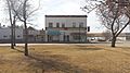
Downtown Kenmare
-
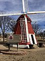
Danish Mill


See also
 In Spanish: Kenmare (Dakota del Norte) para niños
