
Kennewick, Washington facts for kids
Quick facts for kids
Kennewick, Washington
|
|
|---|---|
| City of Kennewick | |
.jpg)
Aerial view of Kennewick from above the Columbia River near the Blue Bridge.
|
|

Location of Kennewick, Washington
|
|

Kennewick, Washington
Location in the United States
|
|
| Country | United States |
| State | Washington |
| County | Benton |
| Government | |
| • Type | Council–manager |
| Area | |
| • City | 28.84 sq mi (74.70 km2) |
| • Land | 27.45 sq mi (71.09 km2) |
| • Water | 1.39 sq mi (3.61 km2) |
| Elevation | 407 ft (124 m) |
| Population
(2010)
|
|
| • City | 73,917 |
| • Estimate
(2019)
|
84,347 |
| • Rank | US: 411th WA: 14th |
| • Density | 3,072.86/sq mi (1,186.42/km2) |
| • Urban | 232,954 (US: 171st) |
| • Metro | 296,224 (US: 164th) |
| • CSA | 357,146 (US: 103rd) |
| • Tri-Cities | 215,024 |
| Time zone | UTC−8 (Pacific (PST)) |
| • Summer (DST) | UTC−7 (PDT) |
| ZIP Codes |
99336–99338
|
| Area code(s) | 509 |
| FIPS code | 53-35275 |
| GNIS feature ID | 1512347 |
| Website | go2kennewick.com |
Kennewick is a city in Benton County in the U.S. state of Washington. It is located along the southwest bank of the Columbia River, just southeast of the confluence of the Columbia and Yakima rivers and across from the confluence of the Columbia and Snake rivers. It is the most populous of the three cities collectively referred to as the Tri-Cities (the others being Pasco and Richland). The population was 73,917 at the 2010 census; the Census Bureau estimates the city's population to be 84,347 as of July 1, 2019[update].
The discovery of Kennewick Man along the banks of the Columbia River provides evidence of Native Americans' settlement of the area for at least 9,000 years. American settlers began moving into the region in the late 19th century as transportation infrastructure was built to connect Kennewick to other settlements along the Columbia River. The construction of the Hanford Site at Richland accelerated the city's growth in the 1940s as workers from around the country came to participate in the Manhattan Project. While Hanford and Pacific Northwest National Laboratory continue to be major sources of employment, the city's economy has diversified over time and Kennewick today hosts offices for Amazon and Lamb Weston.
Contents
History

The name "Kennewick" is believed to be a native word meaning "grassy place." It has also been called "winter paradise," mostly because of the mild winters in the area. In the past, Kennewick has also been known by other names. Legend has it that the strangest was "Tehe," which has been attributed to the reaction from a native girl's laughter when asked the name of the region.
During the 1880s, steamboats and railroads connected what would become known as Kennewick to the other settlements along the Columbia River. In 1887, a temporary railroad bridge was constructed by the Northern Pacific Railroad connecting Kennewick and Pasco. That bridge could not endure the winter ice on the Columbia and was partially swept away in the first winter. A new, more permanent bridge was built in its place in 1888. Until this time, rail freight from Minneapolis to Tacoma had to cross the Columbia River via ferry.
In the 1890s, the Northern Pacific Irrigation Company installed pumps and ditches to bring water for agriculture into the Kennewick Highlands. Once there was a reliable water source, orchards and vineyards were developed all over the Kennewick area. Strawberries were another successful crop.
20th century to present
Kennewick was officially incorporated on February 5, 1904. In 1912, there was an unsuccessful bid to move the seat of Benton County from Prosser to Kennewick.
In 1915, Kennewick was connected to the Pacific Ocean with the opening of the Dalles-Celilo Canal.
In the prologue to World War II, the United States opened the Hanford nuclear site roughly nine miles northwest of Kennewick. Its purpose originally was to help produce nuclear weaponry, which the US was trying to develop. The plutonium refined there was used in the Fat Man bomb used to attack Nagasaki in 1945 in the decisive final blow of World War II. Many employees of that site then commuted from Kennewick. As the Hanford site's purpose has evolved, there has continually been a tremendous influence from the site on the workforce and economy of Kennewick.
In 1996, an ancient human skeleton was found on a bank of the Columbia River. Known as Kennewick Man, the remains are notable for their age (some 9,300 years). Ownership of the bones has been a matter of great controversy. After court litigation, a group of researchers were allowed to study the remains and perform various tests and analyses. They published their results in a book in 2014. A 2015 genetic analysis confirmed that this ancient skeleton was ancestral to Native Americans of the area (some observers had contended that the remains were of European origin.) The genetic analysis has notably contributed to knowledge about the peopling of the Americas.
Attractions

Kennewick lies along the Columbia River and the famous Lewis and Clark Trail marked during the 1804-1806 exploration of the newly acquired Louisiana Territory, reaching to the Pacific Coast.

As of 2013, the historical downtown area is undergoing a rebirth. Historic buildings have been adapted to new uses and the compact, pedestrian-oriented area has attracted a diverse mix of businesses. These include a specialty gift boutique in a newly restored building, art galleries, wine bars and local breweries, upscale dining, and a full-service hardware center.
“Public artwork and recent streetscape improvements create a pleasing pedestrian environment. Through its efforts, the Historic Downtown Kennewick Partnership is creating new life for the commercial district while working to protect its pioneer heritage and historic buildings.”
The streets of downtown Kennewick are home to several bronze art sculptures.
Kennewick is the host city of the Tri-City Americans of the Western Hockey League and the Tri-City Outlaws of the United States Premier Hockey League. They both play their home games in the Toyota Center, which hosts many other regional events.
Every year during the summer, hydroplane racing takes place at the Water Follies event on the Columbia River. Residents from all of southeastern Washington come to Kennewick to shop in the city's commercial district, the center point of which is Columbia Center Mall.
Also, every year in August, the Benton-Franklin County Fair is held at the fairgrounds. Kennewick is the site of the annual Titanium Man (International Distance) and Plutonium Man (Half-Iron Distance) triathlons, attracting international contestants and observers.

- World Trade Center Memorial Monument:
A 9/11 – World Trade Center Memorial Monument is in its Southridge area. Kennewick is one of a few cities to have acquired an external vertical support column artifact salvaged from the World Trade Center. Lampson International worked in conjunction with the City of Kennewick and the Port Authorities of New York and New Jersey to facilitate the monument's fabrication. The central part of the monument is a 35-foot (11 m) twisted column of steel weighing nearly 6,000 pounds (2,700 kg).
The memorial site was dedicated on the 10th anniversary of the tragedy in memory of the 2,977 men and women who lost their lives on September 11, 2001. The memorial is located at the Southridge Sports Complex at the southern entrance to the City of Kennewick. The site includes landscaping and benches placed for reflection and contemplation, and a US flag above the steel monument.

- Clover Island:
In May 2010, a 62-foot lighthouse was constructed on Clover Island (located on the Columbia River) in Kennewick. According to the Port of Kennewick, this is the first lighthouse since 1962 to be built in the United States, and the most recently constructed one in the state of Washington. The United States Coast Guard-approved lighthouse flashes a beacon every four seconds.
Clover Island is a 16-acre recreational destination near downtown Kennewick. It has restaurants, a hotel, and a yacht club, all enhanced by new public access for views of the river. By “constructing a gateway, pathway, lighthouse and public plaza on Clover Island, the Port of Kennewick created physical and visual access to the Columbia River and transformed a ‘distressed neighborhood’ into an urban waterfront destination.” Clover Island offers access to the beautiful scenery along the Columbia and continues to be a popular destination for recreation, wildlife viewing, and entertainment.
Geography

Kennewick is located 213 miles (343 km) east of Portland, Oregon and 225 miles (362 km) southeast of Seattle, Washington. As part of the Tri-Cities, Kennewick is part of the second largest metropolitan area in eastern Washington.
Kennewick is located at 46°12′13″N 119°9′33″W / 46.20361°N 119.15917°W (46.203475, −119.15927).
According to the United States Census Bureau, the city has a total area of 28.36 square miles (73.45 km2), of which, 26.93 square miles (69.75 km2) is land and 1.43 square miles (3.70 km2) is water.
Climate
Kennewick has a semi-arid climate (Köppen BSk), that closely borders on a desert climate (Köppen BWk). Winters are chilly but not severe, with frequent light rainfall, and hot, very dry summers made tolerable by the low humidity. Snowfall is light owing to the influence of the Cascade rain shadow, and the city receives less than half the rainfall of Spokane and less than one-eighth as much as Astoria on the Pacific coast.
| Climate data for Kennewick, Washington | |||||||||||||
|---|---|---|---|---|---|---|---|---|---|---|---|---|---|
| Month | Jan | Feb | Mar | Apr | May | Jun | Jul | Aug | Sep | Oct | Nov | Dec | Year |
| Record high °F (°C) | 68 (20) |
74 (23) |
80 (27) |
95 (35) |
108 (42) |
113 (45) |
117 (47) |
114 (46) |
102 (39) |
89 (32) |
79 (26) |
68 (20) |
117 (47) |
| Average high °F (°C) | 40.4 (4.7) |
47.9 (8.8) |
58.0 (14.4) |
66.2 (19.0) |
74.1 (23.4) |
81.6 (27.6) |
89.3 (31.8) |
88.9 (31.6) |
79.5 (26.4) |
66.3 (19.1) |
50.4 (10.2) |
41.1 (5.1) |
65.3 (18.5) |
| Average low °F (°C) | 28.0 (−2.2) |
31.3 (−0.4) |
36.4 (2.4) |
42.3 (5.7) |
49.2 (9.6) |
55.8 (13.2) |
61.0 (16.1) |
60.5 (15.8) |
51.8 (11.0) |
41.9 (5.5) |
35.7 (2.1) |
29.3 (−1.5) |
43.6 (6.4) |
| Record low °F (°C) | −19 (−28) |
−16 (−27) |
11 (−12) |
21 (−6) |
28 (−2) |
37 (3) |
42 (6) |
39 (4) |
26 (−3) |
9 (−13) |
−11 (−24) |
−11 (−24) |
−19 (−28) |
| Average precipitation inches (mm) | 1.08 (27) |
0.81 (21) |
0.73 (19) |
0.56 (14) |
0.64 (16) |
0.51 (13) |
0.22 (5.6) |
0.18 (4.6) |
0.30 (7.6) |
0.60 (15) |
1.00 (25) |
1.13 (29) |
7.76 (196.8) |
| Average snowfall inches (cm) | 4.4 (11) |
1.0 (2.5) |
0.0 (0.0) |
0 (0) |
0 (0) |
0 (0) |
0 (0) |
0 (0) |
0 (0) |
0 (0) |
0.5 (1.3) |
2.2 (5.6) |
8.1 (20.4) |
| Average precipitation days (≥ 0.01 inch) | 9.6 | 7.8 | 7.9 | 5.5 | 5.3 | 4.4 | 2.5 | 2.7 | 3.5 | 4.9 | 8.9 | 9.3 | 72.3 |
| Average snowy days (≥ 0.1 inch) | 1.8 | 0.5 | 0.0 | 0 | 0 | 0 | 0 | 0 | 0 | 0 | 0.3 | 0.9 | 3.5 |
Demographics
| Historical population | |||
|---|---|---|---|
| Census | Pop. | %± | |
| 1900 | 183 | — | |
| 1910 | 1,219 | 566.1% | |
| 1920 | 1,684 | 38.1% | |
| 1930 | 1,519 | −9.8% | |
| 1940 | 1,918 | 26.3% | |
| 1950 | 10,106 | 426.9% | |
| 1960 | 14,244 | 40.9% | |
| 1970 | 15,212 | 6.8% | |
| 1980 | 34,397 | 126.1% | |
| 1990 | 42,155 | 22.6% | |
| 2000 | 54,693 | 29.7% | |
| 2010 | 73,917 | 35.1% | |
| 2019 (est.) | 84,347 | 14.1% | |
| Population History
|
|||
2010 census
As of the 2010 census, there were 73,917 people, 27,266 households, and 18,528 families residing in the city. The population density was 2,744.8 inhabitants per square mile (1,059.8/km2). There were 28,507 housing units at an average density of 1,058.6 per square mile (408.7/km2). The racial makeup of the city was 78.5% White, 1.7% African American, 0.8% Native American, 2.4% Asian, 0.2% Pacific Islander, 12.1% from other races, and 4.3% from two or more races. Hispanic or Latino of any race were 24.2% of the population.
Of the 27,266 households, 37.9% had children under the age of 18 living with them, 49.3% were married couples living together, 13.0% had a female householder with no husband present, 5.7% had a male householder with no wife present, and 32.0% were non-families. 25.7% of all households were made up of single individuals and 8.8% had someone living alone who was 65 years of age or older. The average household size was 2.67 and the average family size was 3.22.
The median age in the city was 32.6 years. 28.2% of residents were under the age of 18; 10.3% were between the ages of 18 and 24; 26.8% were from 25 to 44; 23.8% were from 45 to 64; and 10.9% were 65 years of age or older. The gender makeup of the city was 49.9% male and 50.1% female.
Sister cities
Kennewick has the following sister cities:
 Yingge, Taiwan
- Taoyuan District, Taiwan
Economy
Kennewick's economy is closely tied to the rest of the Tri-Cities and is heavily influenced by the Hanford Site and the national laboratory. The agriculture and healthcare industries also employ many residents. It has developed to become the retail hub of the Tri-Cities and hosts the only mall in the area—Columbia Center Mall. As such, Kennewick draws in shoppers from a significant portion of southeast Washington and northeast Oregon. Aside from the commercial area around the mall, the other significant retail districts include the historic downtown area and the newly developed Southridge district.
Many agricultural commodities are grown near Kennewick, and many of these pass through the city to be processed and/or transported to other markets for consumption. Boise, Idaho-based Lamb Weston, a division of ConAgra Foods, has corporate offices in Kennewick and Tyson Foods does processing in town. Volcanic ash is mixed in with the rich soil of the region, creating ideal growing conditions for numerous crops. Irrigation enhanced the region through further diversification of agricultural products coming from the Columbia Basin to include vineyards and a variety of vegetables and tree fruit. In higher elevations, like much of the Horse Heaven Hills, there is no access to irrigation water, limiting agricultural activities in that area to ranching and growing wheat.
The region is experiencing consistent job growth, which is creating a large population boom. Home prices have increased by about 10% annually in Kennewick for the past several years, with slower increases having occurred before 2016. Despite this growth, unemployment remained above both the national and state averages in 2020. Recently, industrial growth in Hermiston and at the Port of Morrow in Boardman has led to an increase in the number of Kennewick residents who commute to those areas for work. This is further enhanced by a housing shortage in northeast Oregon.
Education
Out of the city's residents who are 25 years or older, 88% hold a high school diploma (or equivalent) with 24% holding a bachelor's degree or better. These rates are higher than Pasco, but lower than Richland. Kennewick does not have any post-secondary institutions, but is located near Columbia Basin College in Pasco or Washington State University Tri-Cities in Richland.
Public schools located in the city are part of the Kennewick School District (KSD). The Kennewick School District has 17 elementary schools, five middle schools, three high schools serving over 18,000 students. A vocational school is operated by KSD—with funding also coming from other local school districts—named the Tri-Tech Skills Center. Vocational programs at Tri-Tech include firefighting, radio broadcasting, and auto body technology. Similarly, KSD contributes funding to Delta High School in Pasco, which is a STEM-focused school drawing students from around the Tri-Cities. KSD also operates Neil F. Lampson Stadium, located at Kennewick High School, which is used to host football and soccer games for the three high schools in town as well as for special events. Lampson Stadium has a capacity of 6,800 people.
There are five private schools for educating children in Kennewick. Many of these are run by Christian churches, including St. Joseph's Catholic School and Bethlehem Lutheran School.
Infrastructure
Transportation

The nearest commercial airport to Kennewick is the Tri-Cities Airport in Pasco, with flights to several major international airports in the western part of the country. The busiest route is between Pasco and Seattle–Tacoma. Pasco also has the station for both Amtrak's Portland-Chicago Empire Builder and Greyhound Lines. The Port of Kennewick formerly operated Vista Field near the Toyota Center as a general aviation airport, but it closed at the end of 2013. The port plans to turn the land into a mixed-use development.
Interstate 82 bypasses Kennewick to the south, connecting to Seattle via Interstate 90 and both Portland and Salt Lake City via Interstate 84. US 395 passes through town from south to north connecting to Spokane, also via Interstate 90. State Route 240 and State Route 397 also pass through Kennewick, but these mostly serve local traffic. SR 240 connects the Hanford Site to Richland and also travels across the Columbia River on the Blue Bridge to Pasco. SR 397 connects both Interstate 82 and Interstate 182 in Pasco (via the Cable Bridge) to Finley, providing a direct route for freight to go to a chemical plant there.
Public transportation in Kennewick is provided by Ben Franklin Transit, which runs several bus routes that provide intra-city service as well as connections to Pasco and Richland. There are two transit centers in Kennewick: the Three Rivers Transit Center near the Toyota Center and the Dayton Transfer Point downtown. The transit authority also operates a dial-a-ride service for disabled persons.
Utilities
Water and sewer services are provided by the city, with electricity coming from Benton Public Utility District. Natural gas comes from Cascade Natural Gas. Kennewick contracts with Waste Management for garbage and recycling collection. Many people use irrigation water sourced from nearby rivers to water their lawns. This system is separate from the water provided by the city. Most of Kennewick is part of the Kennewick Irrigation District, with parts of the east side of town being under the Columbia Irrigation District.
Nearly 80% of Kennewick's energy is hydroelectric, with another 10% coming from nuclear. Altogether, less than 5% of the city's electricity is sourced from fossil fuels.
Notable people
- Adelle August, actress and 1952 Miss Washington USA
- Stu Barnes, former Tri-City Americans and NHL player, now an assistant coach with the Dallas Stars
- Jeremy Bonderman, Major League Baseball pitcher, Detroit Tigers
- Adam Carriker, defensive end for the Washington Redskins of the National Football League and graduate of Kennewick High School
- Rick Emerson, former radio personality
- Janet Krupin, actress, singer, writer, and producer
- Olaf Kolzig, former Tri-City Americans and NHL goaltender, Washington Capitals
- Damon Lusk, NASCAR driver
- Ray Mansfield, National Football League player, center, Pittsburgh Steelers
- Michael McShane, United States Judge for the District of Oregon
- Leilani Mitchell, Professional basketball player
- Travis Nelson, Oregon Legislator and graduate of Kennewick High School
- Scot Pollard, former NBA player
- Mike Reilly, NFL quarterback, Pittsburgh Steelers, Green Bay Packers, St. Louis Rams, CFL quarterback, Edmonton Eskimos
- Russ Swan, Major League Baseball pitcher, San Francisco Giants, Seattle Mariners, Cleveland Indians
- Shawn O'Malley, Major League Baseball outfielder, Seattle Mariners
Images for kids
-
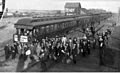
Businessmen from the Seattle Chamber of Commerce visiting Kennewick in 1908.
-
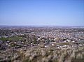
Kennewick from Thompson Hill, which is in the south part of town.
-
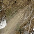
Satellite view of a dust storm in 2009 obscuring parts of Kennewick.
-
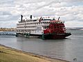
The American Empress stops in the Tri-Cities for wine tours and other excursions.
-
The Toyota Center.
.jpeg)


See also
 In Spanish: Kennewick para niños
