Kent County, Maryland facts for kids
Quick facts for kids
Kent County
|
|||
|---|---|---|---|

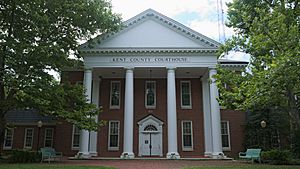
Kent County Courthouse in Chestertown
|
|||
|
|||

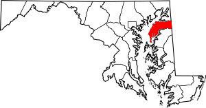
Location within the U.S. state of Maryland
|
|||
 Maryland's location within the U.S. |
|||
| Country | |||
| State | |||
| Founded | December 30, 1642 | ||
| Named for | Kent | ||
| Seat | Chestertown | ||
| Largest town | Chestertown | ||
| Area | |||
| • Total | 413 sq mi (1,070 km2) | ||
| • Land | 277 sq mi (720 km2) | ||
| • Water | 136 sq mi (350 km2) 33% | ||
| Population
(2020)
|
|||
| • Total | 19,198 | ||
| • Density | 46.48/sq mi (17.948/km2) | ||
| Time zone | UTC−5 (Eastern) | ||
| • Summer (DST) | UTC−4 (EDT) | ||
| Congressional district | 1st | ||
Kent County is a county located in the U.S. state of Maryland. As of the 2020 census, its population was 19,198, making it the least populous county in Maryland. Its county seat is Chestertown. The county was named for the county of Kent in England. The county is located on Maryland's Eastern Shore. It is one of three counties in Maryland, along with Caroline and Garrett, that is not part of a Metropolitan Statistical Area.
Contents
History
In 1642, the governor and council appointed commissioners for the Isle and County of Kent. This act appears to have led to the establishment of Kent County. In 1675, the first county seat was New Yarmouth. The seat was briefly moved upriver to Quaker Neck, and then to the site of modern Chestertown. Before the American Revolution New Town on Chester, now Chestertown, was a port entry for the counties of Cecil, Kent, and Queen Anne's.
The county has a number of properties which are listed on the National Register of Historic Places.
In 1793, the county had its first newspaper, called Apollo, or Chestertown Spy. It was succeeded by local papers such as the Chestertown Gazette.
Washington College, the oldest college in Maryland, is located in Kent County.
Geography
According to the U.S. Census Bureau, the county has a total area of 413 square miles (1,070 km2), of which 277 square miles (720 km2) is land and 136 square miles (350 km2) (33%) is water.
According to the Maryland Geological Survey, the highest point in Kent County is 102 ft above sea level, approximately 2.25 mi west of Coleman's Corner (shown on maps as "Coleman"), just northeast of the mouth of Still Pond Creek.
Kent County is the smallest county in Maryland. It has a 209-mile shoreline, including Eastern Neck Island. The Chesapeake Bay is on the west, Sassafras River on the north, and the Chester River on the south. The eastern border with Delaware is part of the Mason–Dixon line.
Adjacent counties
- Cecil County (north)
- New Castle County, Delaware (northeast)
- Kent County, Delaware (southeast)
- Queen Anne's County (south)
Kent County in Maryland and Kent County in Delaware are two of twenty-two counties or parishes in the United States with the same name to border each other across state lines. The others are Union Parish, Louisiana and Union County, Arkansas, Big Horn County, Montana and Big Horn County, Wyoming, Sabine County, Texas and Sabine Parish, Louisiana, Bristol County, Massachusetts and Bristol County, Rhode Island, Escambia County, Alabama and Escambia County, Florida, Pike County, Illinois and Pike County, Missouri, Teton County, Idaho and Teton County, Wyoming, Park County, Montana and Park County, Wyoming, San Juan County, New Mexico and San Juan County, Utah, and Vermilion County, Illinois and Vermillion County, Indiana. respectively. (Note, despite the different spellings, the source of the name is the same for Vermilion County, Illinois and Vermillion County, Indiana—the Vermillion River which flows through both counties.)
National protected area
Demographics
| Historical population | |||
|---|---|---|---|
| Census | Pop. | %± | |
| 1790 | 12,836 | — | |
| 1800 | 11,771 | −8.3% | |
| 1810 | 11,450 | −2.7% | |
| 1820 | 11,453 | 0.0% | |
| 1830 | 10,501 | −8.3% | |
| 1840 | 10,842 | 3.2% | |
| 1850 | 11,386 | 5.0% | |
| 1860 | 13,267 | 16.5% | |
| 1870 | 17,102 | 28.9% | |
| 1880 | 17,605 | 2.9% | |
| 1890 | 17,471 | −0.8% | |
| 1900 | 18,786 | 7.5% | |
| 1910 | 16,957 | −9.7% | |
| 1920 | 15,026 | −11.4% | |
| 1930 | 14,242 | −5.2% | |
| 1940 | 13,465 | −5.5% | |
| 1950 | 13,677 | 1.6% | |
| 1960 | 15,481 | 13.2% | |
| 1970 | 16,146 | 4.3% | |
| 1980 | 16,695 | 3.4% | |
| 1990 | 17,842 | 6.9% | |
| 2000 | 19,197 | 7.6% | |
| 2010 | 20,197 | 5.2% | |
| 2020 | 19,198 | −4.9% | |
| U.S. Decennial Census 1790-1960 1900-1990 1990-2000 2010–2018 |
|||
2010 census
As of the 2010 United States Census, there were 20,197 people, 8,165 households, and 5,272 families living in the county. The population density was 72.9 inhabitants per square mile (28.1/km2). There were 10,549 housing units at an average density of 38.1 per square mile (14.7/km2). The racial makeup of the county was 80.1% white, 15.1% black or African American, 0.8% Asian, 0.2% American Indian, 1.9% from other races, and 1.8% from two or more races. Those of Hispanic or Latino origin made up 4.5% of the population. In terms of ancestry, 18.7% were English, 18.7% were German, 15.5% were Irish, 7.9% were American, and 5.8% were Italian.
Of the 8,165 households, 24.4% had children under the age of 18 living with them, 49.2% were married couples living together, 10.9% had a female householder with no husband present, 35.4% were non-families, and 29.6% of all households were made up of individuals. The average household size was 2.29 and the average family size was 2.78. The median age was 45.6 years.
The median income for a household in the county was $50,141 and the median income for a family was $63,507. Males had a median income of $41,046 versus $35,161 for females. The per capita income for the county was $29,536. About 5.1% of families and 12.2% of the population were below the poverty line, including 14.9% of those under age 18 and 7.8% of those age 65 or over.
Communities
This county contains the following incorporated municipalities:
Towns
- Betterton
- Chestertown (county seat)
- Galena
- Millington (partly in Queen Anne's County)
- Rock Hall
Census-designated places
The United States Census Bureau recognizes the following Census-designated places in Kent County:
Unincorporated communities
Other unincorporated places not listed as Census-Designated Places but known in the area include:
Miscellaneous
- The newspaper of record is the Kent County News.
- Kent County Public Schools were some of the last in the country to fully integrate, but this was because of construction delays in opening the desegregated high school, which opened in the fall of 1969. Primary grade feeder schools in the Kent County system were integrated before the opening of the centrally located high school.
- Kent County, Maryland, is one of the few counties in the United States to border its namesake in another state—in this case, Kent County, Delaware.
- In 1790 Kent County contained the centre of population of the United States, according to the US Census Bureau. It is on the edge of a cornfield at 39.16.30 N 76.11.12 W.
Education
- Kent County High School
- Kent County Middle School
- Galena Elementary School
- Judy Center (Pre-school)
- Henry Highland Garnet Elementary School
- Rock Hall Elementary School
- Kent School
- Chestertown Christian Academy
- Echo Hill Outdoor School
- Radcliffe Creek School
- Washington College
- Chesapeake College (supported in part by the county government, but located in Wye Mills, Md.)
Notable people
- John Cadwalader (1742-1786), Quaker commander during the American Revolutionary War. Served at Princeton, Brandywine, Germantown and Monmouth.
- Captain Lambert Wickes- One of the senior officers of the Continental Navy in the opening years of the Revolution. Noted for his daring raids on British shipping. He took Benjamin Franklin to France in 1776.
- R. Clayton Mitchell Jr. (1936 – 2019), Speaker of the Maryland House of Delegates, 1986–1993. President of the Kent County Commissioners, 1966–1970. Member of the Maryland House of Delegates, 1970–1993.
- John Needles (1786 – 1878), Quaker abolitionist and a master craftsman of fine furniture
- James M. Cain (1892 – 1977), author and journalist lived in Chestertown and taught at Washington College. He published his first novel "The Postman Always Rings Twice" in 1934, it became a movie in 1946. Double Indemnity was filmed in 1949 and in 1945 Mildred Pierce was released.
See also
 In Spanish: Condado de Kent (Maryland) para niños


