
Kidder County, North Dakota facts for kids
Quick facts for kids
Kidder County
|
|
|---|---|

The Kidder County Courthouse in Steele
|
|

Location within the U.S. state of North Dakota
|
|
 North Dakota's location within the U.S. |
|
| Country | |
| State | |
| Founded | January 4, 1873 (created) March 22, 1881 (organized) |
| Named for | Jefferson Kidder |
| Seat | Steele |
| Largest city | Steele |
| Area | |
| • Total | 1,433 sq mi (3,710 km2) |
| • Land | 1,351 sq mi (3,500 km2) |
| • Water | 82 sq mi (210 km2) 5.7% |
| Population
(2020)
|
|
| • Total | 2,394 |
| • Estimate
(2021)
|
2,369 |
| • Density | 1.6706/sq mi (0.6450/km2) |
| Time zone | UTC−6 (Central) |
| • Summer (DST) | UTC−5 (CDT) |
| Congressional district | At-large |
Kidder County is a county located in the U.S. state of North Dakota. As of the 2020 census, the population was 2,394. Its county seat is Steele.
Contents
Geography
According to the U.S. Census Bureau, the county has a total area of 1,433 square miles (3,710 km2), of which 1,351 square miles (3,500 km2) is land and 82 square miles (210 km2) (5.7%) is water.
Lakes
- Alkaline Lake
- Harker Lake
- Lake Isabel
- Long Lake
- Upper Harker Lake
Major highways
 Interstate 94
 North Dakota Highway 3
 North Dakota Highway 36
Adjacent counties
- Wells County (north)
- Stutsman County (east)
- Logan County (south)
- Emmons County (southwest)
- Burleigh County (west)
- Sheridan County (northwest)
National protected areas
- Hutchinson Lake National Wildlife Refuge
- Lake George National Wildlife Refuge
- Long Lake National Wildlife Refuge (part)
- Slade National Wildlife Refuge
Demographics
| Historical population | |||
|---|---|---|---|
| Census | Pop. | %± | |
| 1880 | 89 | — | |
| 1890 | 1,211 | 1,260.7% | |
| 1900 | 1,754 | 44.8% | |
| 1910 | 5,962 | 239.9% | |
| 1920 | 7,798 | 30.8% | |
| 1930 | 8,031 | 3.0% | |
| 1940 | 6,692 | −16.7% | |
| 1950 | 6,168 | −7.8% | |
| 1960 | 5,386 | −12.7% | |
| 1970 | 4,362 | −19.0% | |
| 1980 | 3,833 | −12.1% | |
| 1990 | 3,332 | −13.1% | |
| 2000 | 2,753 | −17.4% | |
| 2010 | 2,435 | −11.6% | |
| 2020 | 2,394 | −1.7% | |
| 2021 (est.) | 2,369 | −2.7% | |
| U.S. Decennial Census 1790-1960 1900-1990 1990-2000 2010-2020 |
|||
2010 census
As of the 2010 census, there were 2,435 people, 1,059 households, and 722 families in the county. The population density was 1.8 inhabitants per square mile (0.69/km2). There were 1,674 housing units at an average density of 1.2 per square mile (0.46/km2). The racial makeup of the county was 96.3% white, 0.9% Asian, 0.2% American Indian, 0.2% black or African American, 1.9% from other races, and 0.4% from two or more races. Those of Hispanic or Latino origin made up 2.9% of the population. In terms of ancestry, 65.8% were German, 21.8% were Norwegian, 8.2% were Russian, 6.0% were English, and 1.7% were American.
Of the 1,059 households, 24.3% had children under the age of 18 living with them, 58.3% were married couples living together, 5.0% had a female householder with no husband present, 31.8% were non-families, and 28.1% of all households were made up of individuals. The average household size was 2.30 and the average family size was 2.77. The median age was 47.2 years.
The median income for a household in the county was $34,250 and the median income for a family was $47,981. Males had a median income of $35,380 versus $24,330 for females. The per capita income for the county was $23,502. About 15.1% of families and 17.9% of the population were below the poverty line, including 29.1% of those under age 18 and 23.1% of those age 65 or over.
Communities
Cities
Unincorporated communities
Townships
- Allen
- Atwood
- Baker
- Buckeye
- Bunker
- Chestina
- Clear Lake
- Crown Hill
- Crystal Springs
- Excelsior
- Frettim
- Graf
- Haynes
- Lake Williams
- Manning
- Merkel
- Northwest
- Peace
- Petersville
- Pettibone
- Pleasant Hill
- Quinby
- Rexine
- Robinson
- Sibley
- Stewart
- Tanner
- Tappen
- Tuttle
- Valley
- Vernon
- Wallace
- Weiser
- Westford
- Williams
- Woodlawn
Unorganized territories
- Kickapoo
- South Kidder
Images for kids
-
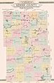
Outline map of Kidder County, North Dakota, 1912

See also
 In Spanish: Condado de Kidder (Dakota del Norte) para niños
