
King County, Washington facts for kids
Quick facts for kids
King County
|
|||
|---|---|---|---|

City Hall Park and King County Courthouse in downtown Seattle
|
|||
|
|||

Location within the U.S. state of Washington
|
|||
 Washington's location within the U.S. |
|||
| Country | |||
| State | |||
| Founded | December 22, 1852 | ||
| Named for |
|
||
| Seat | Seattle | ||
| Largest city | Seattle | ||
| Area | |||
| • Total | 2,307 sq mi (5,980 km2) | ||
| • Land | 2,116 sq mi (5,480 km2) | ||
| • Water | 191 sq mi (490 km2) 8.3% | ||
| Population
(2020)
|
|||
| • Total | 2,269,675 | ||
| • Estimate
(2021)
|
2,252,305 |
||
| • Density | 1,073/sq mi (414/km2) | ||
| Time zone | UTC−8 (Pacific) | ||
| • Summer (DST) | UTC−7 (PDT) | ||
| Congressional districts | 1st, 7th, 8th, 9th | ||


King County is located in the U.S. state of Washington. The population was 2,269,675 in the 2020 census, making it the most populous county in Washington, and the 13th-most populous in the United States. The county seat is Seattle, also the state's most populous city.
King County is one of three Washington counties that are included in the Seattle–Tacoma–Bellevue metropolitan statistical area. (The others are Snohomish County to the north, and Pierce County to the south.) About two-thirds of King County's population lives in Seattle's suburbs.
Etymology
The county was originally named after William Rufus King who was Vice President when the Washington Territory was created in 1853. In 1986, a motion was introduced to change the namesake to Martin Luther King Jr.
On February 24, 1986, the King County Council passed Council Motion 6461 five votes to four setting forth the historical basis for the renaming of King County in honor of Martin Luther King, Jr. Because only the state can charter counties, this change was not made official until April 19, 2005, when the Governor signed Senate Bill 5332 into law.
The County Council submitted a vote to the public on February 27, 2006 to change the county's logo from a royal crown to an image of King. On March 12, 2007, the new logo was unveiled.
Martin Luther King Jr. visited King County for two days in November 1961.
History
The county was formed out of territory within Thurston County on December 22, 1852, by the Oregon Territory legislature, and was named after Alabama resident William R. King, who had just been elected Vice President of the United States under President Franklin Pierce. Seattle was made the county seat on January 11, 1853.
King County originally extended to the Olympic Peninsula. According to historian Bill Speidel, when peninsular prohibitionists threatened to shut down Seattle's saloons, Doc Maynard engineered a peninsular independence movement; King County lost what is now Kitsap County, but preserved its entertainment industry.
On February 24, 1986, the King County Council passed Motion 6461 renaming King County to commemorate the Rev. Dr. Martin Luther King, Jr. (1929-1968), the civil rights leader, rather than William Rufus de Vane King (1786-1853), the vice-president-elect for whom the county was named in 1852. The stated reason for the change was the revelation that "William Rufus DeVane King was a slaveowner and a "gentle slave monger" according to John Quincy Adams."
Geography

According to the U.S. Census Bureau, the county has a total area of 2,307 square miles (5,980 km2), of which 2,116 square miles (5,480 km2) is land and 191 square miles (490 km2) (8.3%) is water. King County has nearly twice the land area of the state of Rhode Island. The highest point in the county is Mount Daniel at 2,426 meters (7,959 feet) above sea level.
King County borders Snohomish County to the north, Kitsap County to the west, Kittitas County to the east, and Pierce County to the south. It also shares a small border with Chelan County to the northeast. King County includes Vashon Island and Maury Island in Puget Sound.
Geographic features

Terrain
- Cascade Range
- Issaquah Alps
- Mount Baker-Snoqualmie National Forest
- Mount Daniel, the highest point
- Mount Si
- Harbor Island
- Maury Island
- Mercer Island
- Sammamish Plateau
- Vashon Island
Water
Major highways
 Interstate 5
 Interstate 90
 Interstate 405
 U.S. Route 2
 State Route 18
 State Route 99
 State Route 520
 State Route 167
Adjacent counties
- Snohomish County – north
- Pierce County – south
- Chelan County – east/northeast
- Kittitas County – east/southeast
- Kitsap County – west
National protected areas
- Klondike Gold Rush National Historical Park (part, also in Skagway, Alaska)
- Snoqualmie National Forest (part)
Demographics
| Historical population | |||
|---|---|---|---|
| Census | Pop. | %± | |
| 1860 | 302 | — | |
| 1870 | 2,120 | 602.0% | |
| 1880 | 6,910 | 225.9% | |
| 1890 | 63,989 | 826.0% | |
| 1900 | 110,053 | 72.0% | |
| 1910 | 284,638 | 158.6% | |
| 1920 | 389,273 | 36.8% | |
| 1930 | 463,517 | 19.1% | |
| 1940 | 504,980 | 8.9% | |
| 1950 | 732,992 | 45.2% | |
| 1960 | 935,014 | 27.6% | |
| 1970 | 1,156,633 | 23.7% | |
| 1980 | 1,269,749 | 9.8% | |
| 1990 | 1,507,319 | 18.7% | |
| 2000 | 1,737,034 | 15.2% | |
| 2010 | 1,931,249 | 11.2% | |
| 2020 | 2,269,675 | 17.5% | |
| 2021 (est.) | 2,252,305 | 16.6% | |
| U.S. Decennial Census 1790–1960 1900–1990 1990–2000 2010–2020 |
|||
The center of population of the state of Washington in 2010 was located in eastern King County (47°19′51″N 121°37′12″W / 47.330750°N 121.619994°W). King County's own center of population was located on Mercer Island (47°32′54″N 122°13′48″W / 47.548320°N 122.229983°W).
As of the fourth quarter of 2021, the median home value in King County was $817,547, an increase of 19.6% from the prior year.
Racial and Ethnic Composition since 1960
| Racial composition | 2020 | 2010 | 2000 | 1990 | 1980 | 1970 | 1960 |
|---|---|---|---|---|---|---|---|
| White (non-Hispanic) | 54.2% | 64.8% | 73.4% | 83.2% | 87.2% | - | - |
| Asian (non-Hispanic) | 19.8% | 14.5% | 10.8% | 7.8% | - | - | 2.0% |
| Hispanic or Latino | 10.7% | 8.9% | 5.4% | 2.9% | 2.1% | 1.8% | - |
| Black or African American (non-Hispanic) | 6.5% | 6.0% | 5.4% | 5.0% | 4.4% | 3.5% | 2.9% |
| Pacific Islander (non-Hispanic) | 0.9% | 0.7% | 0.5% | - | - | - | - |
| Native American (non-Hispanic) | 0.5% | 0.7% | 0.9% | 1.1% | - | - | 0.3% |
| Mixed (non-Hispanic) | 6.8% | 4.1% | 4.0% | - | - | - | - |
2010 census
As of the 2010 census, there were 1,931,249 people, 789,232 households, and 461,510 families residing in the county. The population density was 912.9 inhabitants per square mile (352.5/km2). There were 851,261 housing units at an average density of 402.4 per square mile (155.4/km2). The racial makeup of the county was 68.7% White (64.8% Non-Hispanic White), 6.2% African American, 14.6% Asian, 0.8% Pacific Islander, 0.8% Native American, 3.9% from other races, and 5.0% from two or more races. Those of Hispanic or Latino origin made up 8.9% of the population. In terms of ancestry, 17.1% were German, 11.6% were English, 11.1% were Irish, 5.5% were Norwegian, and 2.9% were American.
Of the 789,232 households, 29.2% had children under the age of 18 living with them, 45.3% were married couples living together, 9.1% had a female householder with no husband present, 41.5% were non-families, and 31.0% of all households were made up of individuals. The average household size was 2.40 and the average family size was 3.05. The median age was 37.1 years.
The median income for a household in the county was $68,065 and the median income for a family was $87,010. Males had a median income of $62,373 versus $45,761 for females. The per capita income for the county was $38,211. About 6.4% of families and 10.2% of the population were below the poverty line, including 12.5% of those under age 18 and 8.6% of those age 65 or over.
Native American tribes
King County is home two federally-recognized tribes, the Muckleshoot tribe and the Snoqualmie Indian Tribe tribe, and other unrecognized groups. The Muckleshoot Indian Reservation is located southeast of Auburn and is home to a resident population of 3,606 as of the 2000 census.
The Snoqualmie tribe's casino property was federally recognized as their reservation in 2006, however few tribe members live near the reservation.
Communities
Cities
- Algona
- Auburn (partial)
- Bellevue
- Black Diamond
- Bothell (partial)
- Burien
- Carnation
- Clyde Hill
- Covington
- Des Moines
- Duvall
- Enumclaw
- Federal Way
- Issaquah
- Kenmore
- Kent
- Kirkland
- Lake Forest Park
- Maple Valley
- Medina
- Mercer Island
- Milton (partial)
- Newcastle
- Normandy Park
- North Bend
- Pacific (partial)
- Redmond
- Renton
- Sammamish
- SeaTac
- Seattle (county seat)
- Shoreline
- Snoqualmie
- Tukwila
- Woodinville
Towns
Census-designated places
- Ames Lake
- Baring
- Boulevard Park
- Bryn Mawr-Skyway
- Cottage Lake
- East Renton Highlands
- Fairwood
- Fall City
- Hobart
- Klahanie (former)
- Lake Holm
- Lake Marcel-Stillwater
- Lake Morton-Berrydale
- Lakeland North
- Lakeland South
- Maple Heights-Lake Desire
- Mirrormont
- Ravensdale
- Riverbend
- Riverton (former)
- Shadow Lake
- Tanner
- Union Hill-Novelty Hill
- Vashon
- White Center
- Wilderness Rim
Other unincorporated communities
- Bayne
- Cedar Falls
- Cumberland
- Denny Creek
- Ernie's Grove
- Grotto
- Kanaskat
- Kangley
- Lake Joy
- Naco
- Palmer
- Preston
- Selleck
- Spring Glen
- Wabash
Ghost towns
Education
K–12 schools
- Auburn School District
- Bellevue School District
- Enumclaw School District
- Federal Way Public Schools
- Highline School District
- Issaquah School District
- Kent School District
- Lake Washington School District
- Mercer Island School District
- Northshore School District
- Renton School District
- Riverview School District
- Seattle Public Schools
- Shoreline School District
- Snoqualmie Valley School District
- Tahoma School District
- Tukwila School District
- Vashon Island School District
Public libraries
Most of King County is served by the King County Library System, while the city of Seattle is served by its own system.
Images for kids
-
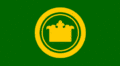
King County's former flag, used from the 1980s to the 2000s
.gif)
See also
 In Spanish: Condado de King (Washington) para niños
