
Kiribati facts for kids
Quick facts for kids
Republic of Kiribati
Ribaberiki Kiribati
|
|
|---|---|
 Coat of arms
|
|
|
Motto: "Te Mauri, Te Raoi ao Te Tabomoa"
"Health, Peace and Prosperity" |
|
.svg) |
|
| Capital and largest city
|
South Tarawa |
| Official languages | |
| Ethnic groups
(2000)
|
98.8% Micronesian 1.2% others |
| Demonym(s) | I-Kiribati |
| Government | Parliamentary republic |
|
• President
|
Taneti Mamau |
|
• Vice-President
|
Kourabi Nenem |
| Legislature | House of Assembly |
| Independence | |
|
• from the United Kingdom
|
12 July 1979 |
| Area | |
|
• Total
|
811 km2 (313 sq mi) (186th) |
| Population | |
|
• 2010 estimate
|
103,500 (197th) |
|
• 2010 census
|
103,500 |
|
• Density
|
135/km2 (349.6/sq mi) (73rd) |
| GDP (PPP) | 2011 estimate |
|
• Total
|
$599 million |
|
• Per capita
|
$5,721 |
| GDP (nominal) | 2011 estimate |
|
• Total
|
$167 million |
|
• Per capita
|
$1,592 |
| HDI (2013) | medium · 121st |
| Currency | Kiribati dollar Australian dollar (AUD) |
| Time zone | UTC+12, +13, +14 |
| Driving side | left |
| Calling code | +686 |
| ISO 3166 code | KI |
| Internet TLD | .ki |

Kiribati (pronounced "KiriBASS") is a country in the Pacific Ocean. It has 33 atolls, groups of tiny islands. The country is near the equator. Its capital is South Tarawa, on the Tarawa atoll. Kiribati's easternmost islands, the southern Line Islands, south of Hawaii, have the most advanced time on Earth: UTC+14 hours.
Kiribati used to be called the Gilbert Islands. In 1892, the Gilbert Islands became a British protectorate with the Ellice Islands (nowadays known as Tuvalu), together called Gilbert and Ellice Islands.
Kiribati became independent from the United Kingdom in 1979. The capital, South Tarawa, which is now the most populated area, consists of a number of islets, connected by a series of causeways. These comprise about half the area of Tarawa Atoll. Kiribati signed a "Treaty of Friendship and Territorial Sovereignty" (also called the "Treaty of Tarawa") with the United States in 1979.
Kiribati is a member of the Pacific Community (SPC), Commonwealth of Nations, the IMF, and the World Bank, and became a full member of the United Nations in 1999.
Contents
Population
.jpg)
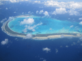
The permanent population is just over 110,000 (2015), more than half of whom live on Tarawa Atoll. The state comprises 32 atolls and reef islands (1.3 million square miles). Their spread reaches both the equator and the 180th meridian. The official languages of Kiribati are English and Gilbertese. It is one of the poorest nations in the Pacific Ocean. It has few natural resources and Tourism is an important industry.
The native people of Kiribati are called I-Kiribati. Ethnically, the I-Kiribati are Micronesians. Recent archaeological evidence indicates that Austronesians originally settled the islands thousands of years ago. Around the 14th century, Fijians, Samoans, and Tongans invaded the islands, thus diversifying the ethnic range and introducing Polynesian language traits. The people of Kiribati speak an Oceanic language called Gilbertese.
Kiribati has competed at the Commonwealth Games since 1998 and the Summer Olympics since 2004. It sent three competitors to its first Olympics, two sprinters and a weightlifter. Kiribati won its first ever Commonwealth Games medal at the 2014 Commonwealth Games when weightlifter David Katoatau won Gold in the 105 kg Group.
Geography
Kiribati consists of 32 atolls and one solitary island (Banaba), extending into the eastern and western hemispheres, as well as the northern and southern hemispheres. It is the only country that is situated within all four hemispheres. The groups of islands are:
- Banaba: an isolated island between Nauru and the Gilbert Islands
- Gilbert Islands: 16 atolls located some 1,500 kilometres (932 mi) north of Fiji
- Phoenix Islands: 8 atolls and coral islands located some 1,800 kilometres (1,118 mi) southeast of the Gilberts
- Line Islands: 8 atolls and one reef, located about 3,300 kilometres (2,051 mi) east of the Gilberts


Banaba (or Ocean Island) is a raised-coral island. It was once a rich source of phosphates, but was exhausted in mining before independence. The rest of the land in Kiribati consists of the sand and reef rock islets of atolls or coral islands, which rise only one or two metres above sea level.
The soil is thin and calcareous. It has a low water-holding capacity and low organic matter and nutrient content—except for calcium, sodium, and magnesium. Banaba is one of the least suitable places for agriculture in the world.
According to the Pacific Regional Environment Programme, two small uninhabited Kiribati islets, Tebua Tarawa and Abanuea, disappeared underwater in 1999. The United Nations Intergovernmental Panel on Climate Change predicts that sea levels will rise by about 50 cm (20 in) by 2100 due to global warming and a further rise would be inevitable. It is likely that within a century the nation's usable land will become subject to increased soil salination and will be largely submerged.
Gradual sea-level rise also allows for coral polyp activity to raise the atolls with the sea level. Also, coral bleaching has led to the death of up to 80% of the coral.
Ecology

Because of the young geological age of the islands and atolls and high level of soil salination the flora of Kiribati is relatively poor. It contains about 83 indigenous and 306 introduced plants on Gilbert Islands, whereas the corresponding numbers for Line and Phoenix Islands are 67 and 283. None of these species are native, and about half of the indigenous ones have a limited distribution and became endangered or nearly extinct due to human activities such as phosphate mining.
Coconut and pandanus palms and breadfruit trees are most common wild plants, whereas the five most cultivated crops are Chinese cabbage, pumpkin, tomato, watermelon and cucumber. Over eighty percent of the population participates in either farming or fishing.
.JPG)
Seaweed farming is an important part of the economy, with two major species introduced to the local lagoons from the Philippines in 1977. There is also the black-lipped pearl oyster, shellfish, strawberry conch and Anadara cockles.
There are 600–800 species of fish, some 200 species of corals and about 1000 species of shellfish. Fishing mostly targets the family Scombridae, particularly the skipjack tuna and yellowfin tuna as well as flying fish.
Kiribati has a few land mammals, they include the Polynesian rat, dogs and pigs. Dogs introduced by European settlers have continued to grow in numbers and are roaming in traditional packs, particularly around South Tarawa.
Images for kids
-
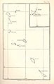
Map of the Gilbert or Kingsmill Islands, 1890
-
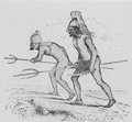
Gilbertese warriors of Tabiteuea, with shark's teeth weapons, c. 1841
-
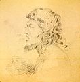
Portrait of a native of the Makin islands, drawn by Alfred Thomas Agate (1841)
-
Declaration of a protectorate on Abemama by Captain EHM Davis, 27 May 1892
-
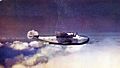
Boeing 314 Clipper in cruise, 1940
-
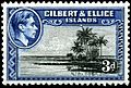
Stamp with portrait of King George VI, 1939
-
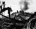
American Marines assault a Japanese bunker during the Battle of Tarawa, November 1943.
-
The Presidential residence, former Government House, Bairiki.
-
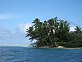
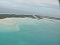
South of Onotoa Atoll
-
A tropical islet with palm fronds oriented in the direction of the prevailing winds.
-
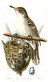
The bokikokiko (Acrocephalus aequinoctialis) is the only land wildlife species endemic to Kiribati.
-
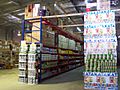
A Bosj's warehouse in Kiribati.
-
Bonriki International Airport.
-
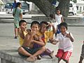
I-Kiribati children in South Tarawa
-

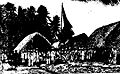
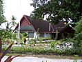
Village on Kiribati
-
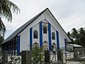
Catholic Church in Betio
-
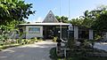
The University of the South Pacific, Kiribati Campus
-
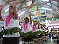
A welcome display.
-
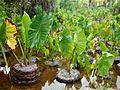
Bwabwai cultivation in Butaritari
-
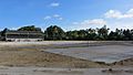
Bairiki National Stadium, at Bairiki, Tarawa


.jpg)
.JPG)


See also
 In Spanish: Kiribati para niños
