
Knightsen, California facts for kids
Quick facts for kids
Knightsen
|
|
|---|---|

Location in Contra Costa County and the state of California
|
|
| Country | United States |
| State | California |
| County | Contra Costa |
| Area | |
| • Total | 8.455 sq mi (21.899 km2) |
| • Land | 8.366 sq mi (21.669 km2) |
| • Water | 0.089 sq mi (0.230 km2) 1.05% |
| Elevation | 30 ft (9 m) |
| Population
(2010)
|
|
| • Total | 1,568 |
| • Density | 185.45/sq mi (71.601/km2) |
| Time zone | UTC-8 (PST) |
| • Summer (DST) | UTC-7 (PDT) |
| ZIP code |
94548
|
| Area code(s) | 925 |
| FIPS code | 06-38772 |
| GNIS feature IDs | 1658916, 2408496 |
Knightsen is a census-designated place (CDP) in Contra Costa County, California, in the United States. As of the 2010 census, the CDP population was 1,568, up from 861 reported in the 2000 census.
Geography
According to the United States Census Bureau, the CDP has a total area of 8.5 square miles (22 km2), 99% of it land.
Demographics
| Historical population | |||
|---|---|---|---|
| Census | Pop. | %± | |
| U.S. Decennial Census | |||
2010
The 2010 United States Census reported that Knightsen had a population of 1,568. The population density was 185.4 people per square mile (71.6/km2). The racial makeup of Knightsen was 1,268 (80.9%) White, 14 (0.9%) African American, 8 (0.5%) Native American, 28 (1.8%) Asian, 3 (0.2%) Pacific Islander, 162 (10.3%) from other races, and 85 (5.4%) from two or more races. Hispanic or Latino of any race were 454 persons (29.0%).
The Census reported that 100% of the population lived in households.
There were 531 households, out of which 182 (34.3%) had children under the age of 18 living in them, 330 (62.1%) were opposite-sex married couples living together, 37 (7.0%) had a female householder with no husband present, 33 (6.2%) had a male householder with no wife present. There were 20 (3.8%) unmarried opposite-sex partnerships, and 6 (1.1%) same-sex married couples or partnerships. 100 households (18.8%) were made up of individuals, and 31 (5.8%) had someone living alone who was 65 years of age or older. The average household size was 2.95. There were 400 families (75.3% of all households); the average family size was 3.34.
The population was spread out, with 383 people (24.4%) under the age of 18, 138 people (8.8%) aged 18 to 24, 328 people (20.9%) aged 25 to 44, 508 people (32.4%) aged 45 to 64, and 211 people (13.5%) who were 65 years of age or older. The median age was 42.6 years. For every 100 females, there were 107.7 males. For every 100 females age 18 and over, there were 106.8 males.
There were 582 housing units at an average density of 68.8 per square mile (26.6/km2), of which 531 were occupied, of which 389 (73.3%) were owner-occupied, and 142 (26.7%) were occupied by renters. The homeowner vacancy rate was 2.5%; the rental vacancy rate was 2.1%. 1,176 people (75.0% of the population) lived in owner-occupied housing units and 392 people (25.0%) lived in rental housing units.
2000
As of the census of 2000, there were 861 people, 281 households, and 214 families residing in the CDP. The population density was 171.7 people per square mile (66.4/km2). There were 289 housing units at an average density of 57.6 per square mile (22.3/km2). The racial makeup of the CDP was 75.96% White, 0.12% Black or African American, 1.39% Native American, 0.23% Asian, 0.70% Pacific Islander, 12.54% from other races, and 9.06% from two or more races. 26.48% of the population were Hispanic or Latino of any race.
There were 281 households, out of which 32.4% had children under the age of 18 living with them, 63.7% were married couples living together, 7.1% had a female householder with no husband present, and 23.8% were non-families. 17.1% of all households were made up of individuals, and 8.9% had someone living alone who was 65 years of age or older. The average household size was 3.04 and the average family size was 3.42.
In the CDP, the population was spread out, with 27.4% under the age of 18, 7.1% from 18 to 24, 27.3% from 25 to 44, 26.6% from 45 to 64, and 11.6% who were 65 years of age or older. The median age was 39 years. For every 100 females, there were 97.9 males. For every 100 females age 18 and over, there were 101.6 males.
The median income for a household in the CDP was $58,929, and the median income for a family was $64,643. Males had a median income of $48,500 versus $32,708 for females. The per capita income for the CDP was $22,191. About 7.3% of families and 8.7% of the population were below the poverty line, including 5.3% of those under age 18 and 19.8% of those age 65 or over.
History
Knightsen, California is a small unincorporated community of 1,568 residents and 1,500 horses in far eastern Contra Costa County, California in the eastern San Francisco Bay Area closest to Oakley, California. The town was founded by George W. Knight. The town's name is a portmanteau of his last name and his wife Christina Christensen. Knightsen has the oldest chapter of the 4-H Club in California. The community is worried about urban sprawl from expanding development in neighboring Oakley.
Knightsen was founded in 1898 when it became a stop for the Atchison Topeka and Santa Fe Railroad. Knightsen has primarily been a farming community, growing such foods as almonds, walnuts, sunflower seeds, etc. It still contains a few U-pick vegetable/fruit stands. Knightsen now is home to many horse ranches.
The first post office in Knightsen was founded in 1900.
Notable residents
- Jeremy Newberry: NFL player.
Images for kids
-
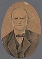
Don José Noriega, a wealthy Californio ranchero, was granted Rancho Los Méganos in 1835, covering all of modern Knightsen.
-
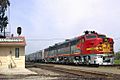
A Santa Fe Railroad charter train at Knightsen in 1968
.jpg)

See also
 In Spanish: Knightsen para niños
