
Knox County, Illinois facts for kids
Quick facts for kids
Knox County
|
|
|---|---|
_1981.jpg)
Knox County Courthouse
|
|

Location within the U.S. state of Illinois
|
|
 Illinois's location within the U.S. |
|
| Country | |
| State | |
| Founded | 1825 |
| Named for | Henry Knox |
| Seat | Galesburg |
| Largest city | Galesburg |
| Area | |
| • Total | 720 sq mi (1,900 km2) |
| • Land | 716 sq mi (1,850 km2) |
| • Water | 3.4 sq mi (9 km2) 0.5% |
| Population
(2010)
|
|
| • Total | 52,919 |
| • Estimate
(2018)
|
50,112 |
| • Density | 73.5/sq mi (28.38/km2) |
| Time zone | UTC−6 (Central) |
| • Summer (DST) | UTC−5 (CDT) |
| Congressional district | 17th |
Knox County is a county in the U.S. state of Illinois. According to the 2020 census, it had a population of 49,967. Its county seat is Galesburg.
Knox County comprises the Galesburg, IL Micropolitan Statistical Area.
Contents
History
Knox County was named in honor of Henry Knox, the first US Secretary of War.
The first "Knox County" in what today is Illinois was unrelated to the modern incarnation. In 1790, the land of the Indiana Territory that was to become Illinois was divided into two counties: St. Clair and Knox. The latter included land in what was to become Indiana. When Knox County, Indiana, was formed from this portion of the county in 1809, the Illinois portions were subdivided into counties that were given other names.
The modern Knox County, Illinois, was organized in 1825, from Fulton County, itself a portion of the original St. Clair County.
Like its neighbor to the south, Fulton County, for its Spoon River Drive, Knox County is also known for a similar scenic drive fall festival the first two weekends in October, the Knox County Drive.
-
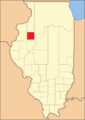
Knox County between its creation in 1825 and 1831
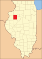
-

Knox County between 1831 and 1839
-
Knox County in 1839, when it was reduced slightly to its current size


Geography
According to the U.S. Census Bureau, the county has a total area of 720 square miles (1,900 km2), of which 716 square miles (1,850 km2) is land and 3.4 square miles (8.8 km2) (0.5%) is water.
Climate and weather
| Weather chart for Galesburg, Illinois | |||||||||||||||||||||||||||||||||||||||||||||||
|---|---|---|---|---|---|---|---|---|---|---|---|---|---|---|---|---|---|---|---|---|---|---|---|---|---|---|---|---|---|---|---|---|---|---|---|---|---|---|---|---|---|---|---|---|---|---|---|
| J | F | M | A | M | J | J | A | S | O | N | D | ||||||||||||||||||||||||||||||||||||
|
1.4
29
13
|
1.6
35
19
|
2.8
48
29
|
3.8
61
40
|
4
73
51
|
4.2
81
61
|
4.4
85
65
|
4.1
82
63
|
3.5
75
55
|
2.5
63
43
|
2.7
47
31
|
2.3
33
19
|
||||||||||||||||||||||||||||||||||||
| temperatures in °F precipitation totals in inches source: The Weather Channel |
|||||||||||||||||||||||||||||||||||||||||||||||
|
Metric conversion
|
|||||||||||||||||||||||||||||||||||||||||||||||
In recent years, average temperatures in the county seat of Galesburg have ranged from a low of 13 °F (−11 °C) in January to a high of 85 °F (29 °C) in July, although a record low of −25 °F (−32 °C) was recorded in January 1982 and a record high of 102 °F (39 °C) was recorded in July 1983. Average monthly precipitation ranged from 1.41 inches (36 mm) in January to 4.37 inches (111 mm) in July.
Major highways
 Interstate 74
 U.S. Highway 34
 U.S. Highway 150
 Illinois Route 8
 Illinois Route 17
 Illinois Route 41
 Illinois Route 78
 Illinois Route 97
 Illinois Route 164
 Illinois Route 116
 Illinois Route 167
 Illinois Route 180
Adjacent counties
- Henry County - north
- Stark County - east
- Peoria County - southeast
- Fulton County - south
- Warren County - west
- Mercer County - northwest
Demographics
| Historical population | |||
|---|---|---|---|
| Census | Pop. | %± | |
| 1830 | 274 | — | |
| 1840 | 7,060 | 2,476.6% | |
| 1850 | 13,279 | 88.1% | |
| 1860 | 28,663 | 115.9% | |
| 1870 | 39,522 | 37.9% | |
| 1880 | 38,344 | −3.0% | |
| 1890 | 38,752 | 1.1% | |
| 1900 | 43,612 | 12.5% | |
| 1910 | 46,159 | 5.8% | |
| 1920 | 46,727 | 1.2% | |
| 1930 | 51,336 | 9.9% | |
| 1940 | 52,250 | 1.8% | |
| 1950 | 54,366 | 4.0% | |
| 1960 | 61,280 | 12.7% | |
| 1970 | 61,280 | 0.0% | |
| 1980 | 61,607 | 0.5% | |
| 1990 | 56,393 | −8.5% | |
| 2000 | 55,836 | −1.0% | |
| 2010 | 52,919 | −5.2% | |
| 2020 | 49,967 | −5.6% | |
| U.S. Decennial Census 1790-1960 1900-1990 1990-2000 2010-2013 |
|||

As of the 2010 United States Census, there were 52,919 people, 21,535 households, and 13,324 families residing in the county. The population density was 73.9 inhabitants per square mile (28.5/km2). There were 24,077 housing units at an average density of 33.6 per square mile (13.0/km2). The racial makeup of the county was 87.5% white, 7.2% black or African American, 0.6% Asian, 0.2% American Indian, 1.9% from other races, and 2.5% from two or more races. Those of Hispanic or Latino origin made up 4.8% of the population. In terms of ancestry, 23.1% were German, 14.9% were Irish, 11.7% were English, 11.6% were Swedish, and 8.0% were American.
Of the 21,535 households, 27.2% had children under the age of 18 living with them, 45.7% were married couples living together, 11.9% had a female householder with no husband present, 38.1% were non-families, and 32.3% of all households were made up of individuals. The average household size was 2.27 and the average family size was 2.84. The median age was 42.0 years.
The median income for a household in the county was $39,545 and the median income for a family was $51,740. Males had a median income of $42,067 versus $25,380 for females. The per capita income for the county was $20,908. About 10.9% of families and 15.5% of the population were below the poverty line, including 24.7% of those under age 18 and 7.3% of those age 65 or over.
Communities
Cities
Villages
Census-designated places
Other unincorporated communities
Townships
Knox County is divided into twenty-one townships:
- Cedar
- Chestnut
- Copley
- Elba
- Galesburg
- Galesburg City
- Haw Creek
- Henderson
- Indian Point
- Knox
- Lynn
- Maquon
- Ontario
- Orange
- Persifer
- Rio
- Salem
- Sparta
- Truro
- Victoria
- Walnut Grove
See also
 In Spanish: Condado de Knox (Illinois) para niños
