
Kohls Ranch, Arizona facts for kids
Quick facts for kids
Kohls Ranch, Arizona
|
|
|---|---|

Kohls Ranch, Arizona
Location in Arizona

Kohls Ranch, Arizona
Location in the United States
|
|
| Country | United States |
| State | Arizona |
| County | Gila |
| Area | |
| • Total | 1.18 sq mi (3.05 km2) |
| • Land | 1.18 sq mi (3.05 km2) |
| • Water | 0.00 sq mi (0.00 km2) |
| Elevation | 5,340 ft (1,630 m) |
| Population
(2020)
|
|
| • Total | 30 |
| • Density | 25.51/sq mi (9.85/km2) |
| Time zone | UTC-7 (MST (no DST)) |
| Area code(s) | 928 |
| FIPS code | 04-38600 |
| GNIS feature ID | 30808 |

Kohls Ranch is a census-designated place (CDP) in Gila County, Arizona, United States. The population was 46 at the 2010 census.
Contents
Geography
The CDP is located in northern Gila County at the southern foot of the Mogollon Rim, in the valley of the upper reaches of Tonto Creek. Arizona State Route 260 forms the northern edge of the CDP, running west 16 miles (26 km) to Payson and east 73 miles (117 km) to Show Low. According to the United States Census Bureau, the Kohls Ranch CDP has a total area of 1.17 square miles (3.03 km2), all of it land.
In the eastern part of the CDP is Camp Tontozona, the training camp for the Arizona State University football team. There are several cabins and a bar in the vicinity, as well as two Tonto National Forest campgrounds. The Arizona State University Geology Department also uses the Camp Tontozona facilities for its geology field camp.
Transportation
Mountain Valley Shuttle stops in Kohl's Ranch on its Phoenix-Show Low route.
Images for kids
-
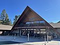
Kohl's Ranch Lodge
-
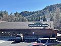
Kohl's Ranch Zane Grey Country BBQ


See also
 In Spanish: Kohls Ranch para niños
