
Korean Demilitarized Zone facts for kids
Quick facts for kids Korean Demilitarized Zone |
|
|---|---|
| Korean Peninsula | |

A South Korean checkpoint in the DMZ
|
|

The Korean DMZ is shown in red with the Military Demarcation Line (MDL) shown with the black line
|
|
| Type | DMZ |
| Site information | |
| Controlled by | |
| Open to the public |
Restricted - No Public Access |
| Condition | Fully manned and operational |
| Site history | |
| Built by | |
| In use | July 27, 1953 onwards |
| Events | Division of Korea |
The Korean Demilitarized Zone is a piece of land running across the Korean Peninsula that serves as a buffer zone between North and South Korea. The DMZ cuts the Korean Peninsula almost in half, crossing the 38th parallel.
The west end of the DMZ is south of the parallel and the east end is to the north of it. It is 250 kilometres (160 miles) long, and about 4 km (2.5 mi) wide and is the most highly militarized border in the world. The border between both Korea's in the Yellow Sea and its coastline is known as the Northern Limit Line. Both sides of the Northern Limit Line are also heavily guarded.
Contents
History

The 38th parallel north cuts the Korean peninsula roughly in half. The parallel was the original boundary between the US-occupied and Soviet-occupied areas of Korea at the end of World War II. When the Democratic People's Republic of Korea (DPRK, informally North Korea) and the Republic of Korea (ROK, informally South Korea) were created in 1948, this line became an international border between the two countries. It was also one of the most tense fronts in the Cold War.
Both the North and the South remained heavily dependent on their sponsor states from 1948 to the outbreak of the Korean War. The conflict claimed over three million lives and divided the Korean Peninsula along ideological lines. On June 25, 1950, a Soviet-sponsored DPRK invasion crossed the 38th parallel. The conflict ended three years later. International troops had been deployed and pushed the frontline back to near the 38th parallel.
In the ceasefire of July 27, 1953, the DMZ was created. Each side agreed in the armistice to move their troops back 2,000 m (2,200 yards) from the front line, creating a buffer zone 4 km (2.5 mi) wide. The Military Demarcation Line (MDL) goes down the center of the DMZ and indicates exactly where the front was when the agreement was signed.

In theory, this is a stalemate. Neither side won or lost. Because of this, both sides of the conflict are still enemies, and a large number of troops are still stationed along both sides of the line. The armistice agreement explains exactly how many military personnel and what kind of weapons are allowed in the DMZ. Soldiers from both sides may patrol inside the DMZ, but they may not cross the MDL. Random outbreaks of violence due to North Korean hostilities killed over 500 South Korean soldiers and 50 U.S. soldiers along the DMZ between 1953 and 1999.
Tae Sung Dong and Kijong-dong were the only villages allowed by the armistice committee to remain within the boundaries of the DMZ. Residents of Tae Sung Dong are governed and protected by the United Nations Command and are generally required to spend at least 240 nights per year in the village to maintain their residency. In 2008, the village had a population of 218 people. The villagers of Tae Sung Dong are direct descendants of people who owned the land before the 1950-53 Korean War.
Joint Security Area

Inside the DMZ, near the western coast of the peninsula, is a place called Panmunjeom. The Joint Security Area (JSA) is located there. Originally, it was the only connection between North and South Korea. In 2007 a Korail train crossed the DMZ to the North on the new Donghae Bukbu Line built on the east coast of Korea.

There are several buildings on both sides of the Military Demarcation Line 9 MDL). A few are built right on top of the MDL. The Joint Security Area is the location where all negotiations since 1953 have been held, including statements of Korean solidarity, which have generally amounted to little except a slight decline of tensions. The MDL goes through the conference rooms and down the middle of the conference tables where the North Koreans and the United Nations Command (primarily South Koreans and Americans) meet face to face.
In late 2009, South Korean forces and the United Nations Command began renovation of its three guard posts and two checkpoint buildings within the JSA compound. Construction was designed to enlarge and modernise the structures. Work was undertaken a year after North Korea finished replacing four JSA guard posts on its side of the MDL.
Secret tunnels

South Korea has discovered tunnels that cross the DMZ. To build these tunnels, explosives were used. This left certain traces, called "blasting lines". The orientation of these blasting lines shows that the tunnels were built from north to south, North Korea built them.
In total, four tunnels have been discovered, the first on November 15, 1974. North Korea claimed that the tunnels were used for coal mining. No coal has been found in the tunnels. All tunnels were dug in a rock called granite. Some of the tunnel walls have been painted black to give the appearance of anthracite.
It is believed the tunnels were built to allow a North Korean military invasion. Each tunnel is big enough, so an entire infantry division can pass in one hour, but the tunnels are too small for tanks or other vehicles. All the tunnels run in a north-south direction and do not have branches. Engineering within the tunnels, following each discovery, has become progressively more advanced. For example, the third tunnel sloped slightly upwards as it progressed southward, to prevent water stagnation. Today, visitors may visit the second, third and fourth tunnels through guided tours.
Buildings

Both North and South Korea maintain peace villages in sight of each other's side of the DMZ. In the South, Daeseong-dong is administered under the terms of the DMZ. Villagers are classed as Republic of Korea citizens.
In the North, Kijong-dong features a number of brightly painted, poured-concrete multi-story buildings and apartments with electric lighting. These features represented an unheard of level of luxury for rural Koreans, north or south, in the 1950s. The town was oriented so that the bright blue roofs and white sides of the buildings would be the most distinguishing features when viewed from the border. However scrutiny with modern telescopic lenses reveals that the buildings are mere concrete shells lacking window glass or even interior rooms, with the building lights turned on and off at set times and the empty sidewalks swept by a crew of caretakers in an effort to preserve the illusion of activity.

Until 2004, massive loudspeakers mounted on several of the buildings continuously delivered DPRK propaganda broadcasts directed towards the south as well as propaganda radio broadcasts across the border.
Within the JSA are a number of U.N. buildings called Conference Row these are used for direct talks between the two Koreas. In 1994, North Korea enlarged Panmungak by adding a third floor. In 1998, South Korea built a new Freedom House for its Red Cross staff and to possibly host reunions of families separated by the Korean War.
In the 1980s, the South Korean government built a 98.4 m (323 ft) flagpole in the village of Daeseong-dong. The North Korean government responded by building a taller one — the tallest in the world at 160 m (525 ft) in Kijong-dong.
Transportation

Panmunjeom is the site where the negotiations that ended the Korean took place. It is the main centre of human activity in the DMZ today. The village is located on the main highway and near a railroad connecting the two Koreas.
The railway, which connects Seoul and Pyongyang, was called the Gyeongui Line before Korea was divided in the 1940s. Currently the South uses the original name, but the North refers to the route as the P'yŏngbu Line. Today, the railway is mainly used to carry materials to the industrial complexes at Kaesong. South Korea workers also use it to commute there.
When it was reopened in the early 2000s, this was seen as a sign that the relations between both countries were improving. However in November 2008 North Korean authorities closed the railway because of growing tensions with the South. When former South-Korean president Kim Dae-jung had died, a delegation from North Korea also attended his funeral. On that occasion, talks were held with South Korean officials. In September 2009, the Kaesong rail and road crossings were reopened.
The road at Panmunjeom, which was known historically as Highway One in the South, was originally the only access point between the two countries on the Korean Peninsula. Both North and South Korea's roads end in the Joint Security Area; neither highway meets because there is a 20-centimetre (8-inch) concrete line that divides the entire site. People given the permission to cross this border must do so on foot before continuing their journey by road.

In 2007, on the east coast of Korea, the first train crossed the DMZ on the new Donghae Bukbu (Tonghae Pukpu) Line. The new rail crossing was built next to the road which took South Koreans to Kŭmgangsan, a region that has significant cultural importance for all Koreans. More than one million civilian visitors crossed the DMZ until the route was closed in July 2008. Since then the resort, and the Donghae Bukbu Line have effectively been closed by the North.
On 22 November 2018, North and South Korea completed construction to connect a three kilometer road along the DMZ, 90 km northeast of Seoul. This road, which crosses the Korean MDL land border, consists of 1.7 km in South Korea and 1.3 km in North Korea. The road was reconnected for the first time in 14 years in an effort to assist with a process at the DMZ's Arrowhead Hill involving the removal of landmines and the digging up of Korean War remains.
Propaganda

From 1953 until 2004, both sides broadcast audio propaganda across the DMZ. Massive loudspeakers mounted on several of the buildings delivered DPRK propaganda broadcasts directed towards the south as well as propaganda radio broadcasts across the border. In 2004, the North and South agreed to end the broadcasts.
On 4 August 2015, a border incident occurred where two South Korean soldiers were wounded after stepping on landmines that had allegedly been laid on the southern side of the DMZ by North Korean forces near an ROK guard post. Both North Korea and South Korea then resumed broadcasting propaganda by loudspeaker. After four days of negotiations, on 25 August 2015 South Korea agreed to discontinue the broadcasts following a statement from North Korea's government expressing regret for the landmine incident.
On 8 January 2016, in response to North Korea's supposed successful testing of a hydrogen bomb, South Korea resumed broadcasts directed at the North. On 15 April 2016, it was reported that the South Koreans purchased a new stereo system to combat the North's broadcasts.
Both North and South Korea have held balloon propaganda leaflet campaigns since the Korean War. In recent years, mainly South Korean non-governmental organizations have been involved in launching balloons targeted at the DMZ and beyond. As with the loudspeakers, balloon operations were mutually agreed to be halted between 2004 and 2010.
.jpg)
Many North Korean leaflets during the Cold War gave instructions and maps to help targeted South Korean soldiers in defecting. One of the leaflets found on the DMZ included a map of Cho Dae-hum's route of defection to North Korea across the DMZ. In addition to using balloons as a means of delivery, North Koreans have also used rockets to send leaflets to the DMZ.
On 23 April 2018, both North and South Korea officially cancelled their border propaganda broadcasts for the last time. On 1 May 2018, the loudspeakers across the Korean border were dismantled. Both sides also committed to ending the balloon campaigns. The no-fly zone which was established on 1 November 2018 also designated a no-fly zone for all aircraft types above the MDL, and prohibits hot-air balloons from traveling within 25 km of the Korean border's Military Demarcation Line (MDL).
Military Border Crossing
.jpg)
On 12 December 2018, military from both Koreas crossed the DMZ's MDL into the opposition countries for the first time in history to inspect and verify the removal of "frontline" guard posts.
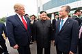
On 30 June 2019, U.S. president Donald Trump became the first sitting U.S. president to enter North Korea, doing so at the DMZ line. After crossing into North Korea, Trump and Kim Jong-un met and shook hands. Kim stated, in English, "It's good to see you again", "I never expected to meet you at this place" and "you are the first U.S. president to cross the border." Both men then briefly crossed the border line before crossing back into South Korea.
On the South Korean side of the of DMZ, Kim, Moon Jae-in, and Trump held a brief chat before holding an hour-long meeting at the DMZ's Inter-Korean House of Freedom.
Nature reserve

In the past half century, the Korean DMZ has been a deadly place for humans, making habitation impossible. Only around the village of Panmunjeom and more recently the Dong Bukbu Line on Korea's east coast have there been regular occupation by people.
This natural isolation along the 155 miles (249 km) length of the DMZ has created an involuntary park which is now recognised as one of the most well-preserved areas of temperate habitat in the world. Several endangered animal and plant species now exist among the heavily fortified fences, landmines and listening posts.

These include the extremely rare Red-crowned Crane (a staple of Asian art), and the White-naped crane as well as, potentially, the extremely rare Korean Tiger, Amur leopard and Asiatic black bear. Ecologists have identified some 2,900 plant species, 70 types of mammals and 320 kinds of birds within the narrow buffer zone. Additional surveys are now being conducted throughout the region.
The DMZ owes its varied biodiversity to its geography which crosses mountains, prairies, swamps, lakes and tidal marshes. Environmentalists hope that by the time reunification occurs, the former DMZ will be conserved as a wildlife refuge.
Images for kids
-
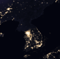
The Korean Demilitarized Zone is visible at night from space due to a noticeable lack of lighting in the northern half of the Korean Peninsula
-
Detail of the DMZ
-
The Korean wall, or anti-tank barrier, in the demilitarized zone seen through binoculars from the North Korean side.
-
DMZ, North Korea. Electric fences are used in the Korean Demilitarized Zone as a means to seal off North Korea from South Korea. Behind the fence, there is a strip which has land mines hidden beneath it.
-
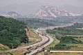
The Donghae Bukbu Line on Korea's east coast. The road and rail link was built for South Koreans visiting the Mount Kumgang Tourist Region in the North.
-
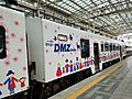
DMZ Train tour organized by Korail
-
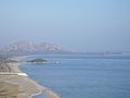
Goesong lookout point
-
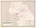
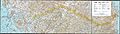
Map of the Korean DMZ
-
Trump with the North and South Korean presidents. This is the first time an American president entered the zone.


.jpg)
See also
 In Spanish: Zona desmilitarizada de Corea para niños
