Kotli District facts for kids
Quick facts for kids
Kotli
|
|
|---|---|

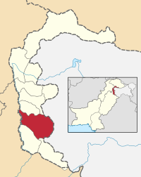
Map of Azad Kashmir with Kotli highlighted
|
|
| Country | Pakistan |
| Established | 1975 |
| Area | |
| • Total | 1,862 km2 (719 sq mi) |
| Population
(1998)
|
|
| • Total | 640,000 |
| • Density | 352/km2 (910/sq mi) |
| Time zone | UTC+5 (PST) |
| Number of Tehsils | 5 |
Kotli (Urdu: ضلع کوٹلی) is one of the eight districts of Azad Kashmir, Pakistan. Kotli is the capital city of the district. Kotli used to be a small town between Mirpur and Muzaffarabad, but has recently grown in size.
Administration
The district of Kotli used to be a sub-division of Mirpur District until 1975. Before 1947, it was a part of the Jammu area. The district is bounded by the Indian part of Kashmir in the east, and by Mirpur District in the south and Rawalakot to its north. The district is divided into three tehsils (sub-divisions)
The district covers a total area of 1862 square kilometres. Kotli is now the largest city by population (656,000).
Before the division of Kashmir in 1947, Nakyal was part of Mehndar sub-division of Poonch.

All content from Kiddle encyclopedia articles (including the article images and facts) can be freely used under Attribution-ShareAlike license, unless stated otherwise. Cite this article:
Kotli District Facts for Kids. Kiddle Encyclopedia.
