
La Crosse County, Wisconsin facts for kids
Quick facts for kids
La Crosse County
|
||
|---|---|---|

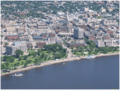
View of the city of La Crosse from Grandad Bluff
|
||
|
||

Location within the U.S. state of Wisconsin
|
||
 Wisconsin's location within the U.S. |
||
| Country | ||
| State | ||
| Founded | 1851 | |
| Seat | La Crosse | |
| Largest city | La Crosse | |
| Area | ||
| • Total | 480 sq mi (1,200 km2) | |
| • Land | 452 sq mi (1,170 km2) | |
| • Water | 28 sq mi (70 km2) 5.9%% | |
| Population
(2020)
|
||
| • Total | 120,784 |
|
| • Estimate
(2019)
|
118,502 | |
| Time zone | UTC−6 (Central) | |
| • Summer (DST) | UTC−5 (CDT) | |
| Congressional district | 3rd | |

La Crosse County is a county located in the U.S. state of Wisconsin. At the 2020 census, the population was 120,784. Its county seat is La Crosse. La Crosse County is included in the La Crosse-Onalaska, WI-MN Metropolitan Statistical Area with a population of 139,627 and is the most populous county on Wisconsin's western border.
Contents
Geography
According to the U.S. Census Bureau, the county has a total area of 480 square miles (1,200 km2), of which 452 square miles (1,170 km2) is land and 28 square miles (73 km2) (5.9%) is water.

Major highways
 Interstate 90
 U.S. Highway 14
 U.S. Highway 53
 U.S. Highway 61
 Highway 16 (Wisconsin)
 Highway 33 (Wisconsin)
 Highway 35 (Wisconsin)
 Highway 108 (Wisconsin)
 Highway 162 (Wisconsin)
Airport
- KLSE - La Crosse Regional Airport
Adjacent counties
- Trempealeau County - northwest
- Jackson County - northeast
- Monroe County - east
- Vernon County - south
- Houston County, Minnesota - southwest
- Winona County, Minnesota - west
Demographics
| Historical population | |||
|---|---|---|---|
| Census | Pop. | %± | |
| 1860 | 12,186 | — | |
| 1870 | 20,297 | 66.6% | |
| 1880 | 27,073 | 33.4% | |
| 1890 | 38,801 | 43.3% | |
| 1900 | 42,997 | 10.8% | |
| 1910 | 43,996 | 2.3% | |
| 1920 | 44,355 | 0.8% | |
| 1930 | 54,455 | 22.8% | |
| 1940 | 59,653 | 9.5% | |
| 1950 | 67,587 | 13.3% | |
| 1960 | 72,465 | 7.2% | |
| 1970 | 80,468 | 11.0% | |
| 1980 | 91,056 | 13.2% | |
| 1990 | 97,904 | 7.5% | |
| 2000 | 107,120 | 9.4% | |
| 2010 | 114,638 | 7.0% | |
| 2020 | 120,784 | 5.4% | |
| U.S. Decennial Census 1790–1960 1900–1990 1990–2000 2010–2020 |
|||

According to 2014–2018 ACS estimates, the median household income was $55,479 and the median family income was $67,388. Males had a median income of $48,675 and females $38,714. The per capita income was $26,065. About 9.1% of families and 10.9% of the population were below the poverty line, including 8.2% of those under age 18 and 7.3% of those age 65 or over.
At the 2010 census, there were 114,638 people, 46,137 households and 27,373 families residing in the county. The population density was 255 per square mile (98/km2). There were 46,137 housing units at an average density of 96 per square mile (37/km2). The racial make up was 92.1% White, 1.4% Black or African American, 0.4% Native American, 4.1% Asian, 0.00% Pacific Islander, 0.3% from other races, and 1.6% from two or more races. 0.92% of the population were Hispanic or Latino of any race. 38.9% were of German, 20.3% Norwegian and 7.9% Irish ancestry. In 2017, there were 1,188 births, giving a general fertility rate of 47.9 births per 1000 women aged 15–44, the fifth lowest rate out of all 72 Wisconsin counties.
Communities
Cities
Villages
Towns
Census-designated places
- Brice Prairie, part of the Town of Onalaska and an urban reserve area of the City of Onalaska
- French Island
- St. Joseph
Unincorporated communities
Images for kids
-
Downtown La Crosse

See also
 In Spanish: Condado de La Crosse para niños
