
La Mirada, California facts for kids
Quick facts for kids
La Mirada, California
|
|||
|---|---|---|---|
| City of La Mirada | |||
|
|||
| Motto(s):
Dedicated to Service
|
|||

Location of La Mirada in Los Angeles County, California
|
|||

La Mirada, California
Location in the Los Angeles metropolitan area

La Mirada, California
Location in California

La Mirada, California
Location in the United States
|
|||
| Country | |||
| State | |||
| County | |||
| Incorporated | March 23, 1960 | ||
| Government | |||
| • Type | Council–Manager | ||
| Area | |||
| • Total | 7.84 sq mi (20.30 km2) | ||
| • Land | 7.82 sq mi (20.26 km2) | ||
| • Water | 0.02 sq mi (0.04 km2) 0.22% | ||
| Elevation | 194 ft (59 m) | ||
| Population
(2010)
|
|||
| • Total | 48,527 | ||
| • Estimate
(2019)
|
48,183 | ||
| • Density | 6,159.93/sq mi (2,378.23/km2) | ||
| Time zone | UTC-8 (Pacific) | ||
| • Summer (DST) | UTC-7 (PDT) | ||
| ZIP codes |
90637–90639
|
||
| Area code | 562, 657/714 | ||
| FIPS code | 06-40032 | ||
| GNIS feature IDs | 1652736, 2411577 | ||


La Mirada (Spanish for "The Look") is a city in southeast Los Angeles County, California United States, and is one of the Gateway Cities. The population was 48,527 at the 2010 census, up from 46,783 at the 2000 census. The La Mirada Theatre for the Performing Arts and the Splash! La Mirada Regional Aquatics Center are two of its main attributes. It is the home of Biola University, an evangelical Christian institution of higher education.
Contents
History
La Mirada (Spanish for the look) was the creation of two men, Andrew McNally, a printer and mapmaker from Chicago (see Rand McNally) and his son-in-law Edwin Neff. In 1888, McNally purchased over 2,200 acres (8.9 km2) of Rancho Los Coyotes, south of Whittier, for $200,000. He developed 700 acres (2.8 km2) into his own home called Windermere Ranch and surrounded it with olive, orange and lemon groves. McNally built a plant to process the olive oil, which was of the best quality, as well as a railroad station on Stage Road. From here his olive oil and fruit were shipped all over the U.S.
In 1896, McNally turned his property over to his daughter and his son in law. McNally and Neff formed the La Mirada Land Company, which published a booklet entitled "The Country Gentleman in California", advertising parcels of land for sale including pictures, a map and descriptions of the scenic olive, alfalfa, lemon and grapefruit groves.
In 1946, "Along Your Way", a "Station by Station Description of the Santa Fe Route Through the Southwest," describes La Mirada with a population of 213, surrounded by orange, lemon, walnut and olive groves; oil wells; olive oil factory; and fruit packing houses.
The city received a lot of attention for the fact that it was going to be completely structured and planned out. Referred to as "the Nation's completely planned city" during the early 1950s, the city of La Mirada received a lot of attention from the State Fair. The Fair praised the city for planning for the future while still maintaining practicality for today.
In 1953, the land was sold to subdivisions for 5.2 million dollars, one of the largest real estate transactions in California. By 1960, the year the city was incorporated, La Mirada had grown from a mere 100 homes to over 8,000. The city was incorporated as "Mirada Hills" on March 23, 1960. On November 8, 1960, voters approved a change of name to the current La Mirada, which was officially certified on December 15, 1960.
Today, the current population is just over 50,000 with the addition of a new subdivision on the eastern portion of the town.
Geography
According to the United States Census Bureau, the city has a total area of 7.9 square miles (20 km2). 7.8 square miles (20 km2) of it is land and 0.02 square miles (0.052 km2) of it (0.22%) is water. The city is on the border between Orange and Los Angeles Counties. The cities that border it on the Los Angeles County side are Santa Fe Springs to the west and Cerritos to the southwest; and unincorporated areas of Los Angeles County East Whittier, and South Whittier to the North. Then the cities which border it on the Orange County side are Fullerton and La Habra on the east; Buena Park on the south; also a small portions of unincorporated Orange County to the northeast.
Demographics
| Historical population | |||
|---|---|---|---|
| Census | Pop. | %± | |
| 1960 | 22,444 | — | |
| 1970 | 30,808 | 37.3% | |
| 1980 | 40,986 | 33.0% | |
| 1990 | 40,452 | −1.3% | |
| 2000 | 46,783 | 15.7% | |
| 2010 | 48,527 | 3.7% | |
| 2019 (est.) | 48,183 | −0.7% | |
| U.S. Decennial Census | |||
2010
The 2010 United States Census reported that La Mirada had a population of 48,527. The population density was 6,175.7 people per square mile (2,384.5/km2). The racial makeup of La Mirada was 29,462 (60.7%) White (38.0% Non-Hispanic White), 1,099 (2.3%) African American, 394 (0.8%) Native American, 8,650 (17.8%) Asian, 142 (0.3%) Pacific Islander, 6,670 (13.7%) from other races, and 2,110 (4.3%) from two or more races. Hispanic or Latino of any race were 19,272 persons (39.7%).
The Census reported that 45,670 people (94.1% of the population) lived in households, 2,586 (5.3%) lived in non-institutionalized group quarters, and 271 (0.6%) were institutionalized.
There were 14,681 households, out of which 5,368 (36.6%) had children under the age of 18 living in them, 8,971 (61.1%) were opposite-sex married couples living together, 1,731 (11.8%) had a female householder with no husband present, 802 (5.5%) had a male householder with no wife present. There were 544 (3.7%) unmarried opposite-sex partnerships, and 93 (0.6%) same-sex married couples or partnerships. 2,536 households (17.3%) were made up of individuals, and 1,578 (10.7%) had someone living alone who was 65 years of age or older. The average household size was 3.11. There were 11,504 families (78.4% of all households); the average family size was 3.48.
The population was spread out, with 10,246 people (21.1%) under the age of 18, 7,092 people (14.6%) aged 18 to 24, 11,609 people (23.9%) aged 25 to 44, 12,203 people (25.1%) aged 45 to 64, and 7,377 people (15.2%) who were 65 years of age or older. The median age was 37.9 years. For every 100 females, there were 92.2 males. For every 100 females age 18 and over, there were 89.4 males.
There were 15,092 housing units at an average density of 1,920.7 per square mile (741.6/km2), of which 11,608 (79.1%) were owner-occupied, and 3,073 (20.9%) were occupied by renters. The homeowner vacancy rate was 0.8%; the rental vacancy rate was 4.0%. 36,660 people (75.5% of the population) lived in owner-occupied housing units and 9,010 people (18.6%) lived in rental housing units.
During 2009–2013, La Mirada had a median household income of $81,961, with 7.0% of the population living below the federal poverty line.
2000
As of the census of 2000, there were 46,783 people, 14,580 households, and 11,518 families residing in the city. The population density was 5,960.6 inhabitants per square mile (2,301.0/km2). There were 14,811 housing units at an average density of 1,887.1 per square mile (728.5/km2). The racial makeup of the city was 64.46% White, 1.93% Black or African American, 0.75% American Indian, 14.88% Asian, 0.27% Pacific Islander, 13.64% from other races, and 4.08% from two or more races. 33.47% of the population were Hispanic or Latino of any race.
There were 14,580 households, out of which 37.4% had children under the age of 18 living with them, 64.1% were married couples living together, 10.4% had a female householder with no husband present, and 21.0% were non-families. 17.3% of all households were made up of individuals, and 10.0% had someone living alone who was 65 years of age or older. The average household size was 3.10 and the average family size was 3.49.
In the city, the population was spread out, with 26.2% under the age of 18, 10.7% from 18 to 24, 28.5% from 25 to 44, 20.8% from 45 to 64, and 13.8% who were 65 years of age or older. The median age was 35 years. For every 100 females, there were 93.3 males. For every 100 females age 18 and over, there were 88.3 males.
The median income for a household in the city was $61,632, and the median income for a family was $66,598 (these figures had risen to $77,952 and $87,037 respectively as of a 2007 estimate). Males had a median income of $47,364 versus $31,993 for females. The per capita income for the city was $22,404. About 3.7% of families and 5.6% of the population were below the poverty line, including 6.1% of those under age 18 and 4.5% of those age 65 or over.
Transportation
Metrolink operates commuter rail service on this right-of-way; the nearest stations to La Mirada are Buena Park and Norwalk/Santa Fe Springs. Public transportation is provided by the Los Angeles County Metropolitan Transportation Authority (Metro), Norwalk Transit, and Montebello Bus Lines.
The main arterial streets running west-to-east are Rosecrans Avenue, Alondra Boulevard, and Imperial Highway. The main arterial streets running south-to-north are Valley View Avenue, La Mirada Boulevard, and Santa Gertrudes Avenue. Leffingwell Road runs along the north end of the city, and Artesia Boulevard runs along the south end of the city. Interstate 5 passes briefly through the southwest corner of the city, while Beach Boulevard (SR 39) passes briefly through the east end of the city.
Freight railroad traffic through the city is handled by BNSF Railway on its right-of-way in the southwest portion of the city. Union Pacific Railroad operates a rail line along Interstate 5 and serves the southern industrial areas south of I-5.
Economy
Top employers
According to the city's 2017 Demographic Overview, the top employers in the city are:
| # | Employer | # of Employees |
|---|---|---|
| 1 | Biola University | 1,365 |
| 2 | Norwalk-La Mirada Unified School District | 843 |
| 3 | US Food Service | 650 |
| 4 | Kindred Hospital La Mirada | 266 |
| 5 | City of La Mirada | 306 |
Education
Public education in a majority of La Mirada is governed by the Norwalk-La Mirada Unified School District, headquartered in neighboring Norwalk. La Mirada has one public secondary school, La Mirada High School.
The Creek Park and Granada Heights neighborhoods in northern La Mirada are within the boundaries of the East Whittier City School District K - 8th grade, the Whittier Union High School District, and Rio Hondo College District all with campuses in nearby Whittier.
Several private schools are located in La Mirada:
- St. Paul of the Cross School in the Foster Park neighborhood
- Beatitudes of Our Lord School
The city is home to one private higher education institution, Biola University.
According city's 2017 Demographic Overview (which is collected from sources deemed reliable, including US Census, ESRI, GCR Marketing Network, Claritas, HDL and city, state & county data), approximately 26.23% of the population have some college education, 9.8% have an associate degree, 20.08% have a Bachelor's degree, 8.05% have a Master's Degree, and 1.05% have a Doctorate Degree.
Notable people
- Gary Allan, country singer, born in La Mirada
- Ila Borders, female baseball pitcher
- Derby Carillo, American-born Salvadoran soccer player
- Tony Corrente, NFL referee
- Chase De Leo, professional ice hockey player for the New Jersey Devils
- Jennie Finch, Olympic softball player
- Steven L. Kwast, Air Force lieutenant general
- Cole McDonald, football player for the Toronto Argonauts
- Keith McGill, football player for the Oakland Raiders
- Shotaro Omori, American figure skater
- Daniel Poncedeleon, Major League Baseball pitcher for the St. Louis Cardinals
- Amber Riley, actor and singer best known for her role in Glee
- Ryan Vargas, NASCAR driver
- Derrick Williams, basketball player for the Sacramento Kings
- Eric Winter, actor best known for his role in Days of Our Lives
- YTCracker, former hacker, nerdcore rapper
Images for kids
-
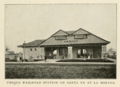
La Mirada depot, from a 1903 publication

See also
 In Spanish: La Mirada para niños
