
La Perla, San Juan, Puerto Rico facts for kids


La Perla is a historical shanty town astride the northern historic city wall of Old San Juan, Puerto Rico, stretching about 650 yards (600 m) along the rocky Atlantic coast immediately east of the Santa Maria Magdalena de Pazzis Cemetery and down the slope from (north of) Calle Norzagaray.
La Perla was established in the 18th century. Initially, the area was the site of a slaughterhouse because the law required the homes of former slaves and homeless non-white servants – as well as cemeteries – to be established away from the main community center; in this case, outside the city walls. Sometime after, some of the farmers and workers started living around the slaughterhouse and shortly established their houses there.
Contents
Streets
The streets of La Perla are not indicated on most city maps in order to deter tourists from walking into the high crime area:
- Calle Tiburcio Reyes (western border, along the outside of the old city wall)
- Calle San Miguel (mostly in the western part, along the north)
- Calle Bajada Matadero (mostly in the western part, along the south)
- Calle Lucila Silva (mostly in the western part, east-west through the middle, too narrow for cars)
- Calle Augustin O Aponte (eastern part)
La Perla was the true site of the fictional "La Esmeralda" barrio depicted in Oscar Lewis's sociological work "La Vida" describing the lives of Puerto Rican slumdwellers through taped interviews with dozens of intertwined family members who lived there in the 1940s-1960s.
Census
In terms of the United States 2000 Census, La Perla is composed of Census blocks 3001 through 3010 (Block group 3, Census tract 4, San Juan, Puerto Rico). A population of 338 was reported, 198 housing units (29 unoccupied), and 169 households, on an area of 80,028 square yards (16.53 acres; 66,914 m²).
La Perla belongs to and consists of the northernmost stretches of the sub-barrios Mercado (west) and San Cristóbal (east) of Old San Juan. The dividing line between the subbarrios is the imagined extension of Calle San Justo to the north beyond the old city wall to the Atlantic coast. The eastern part consists of Census blocks 3002, 3009 und 3010, with a population of 64, 35 housing units (4 unoccupied), and 31 households, on 41,348 square yards (8.5 acres; 34,572 m²).
Images for kids
-

La Perla is within two subbarrios, Mercado and San Cristobal
-
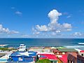
View of La Perla from basketball court
-
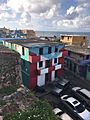
Building in La Perla, San Juan, Puerto Rico
-
2009 in La Perla
-
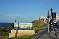
Comunidad La Perla sign
-
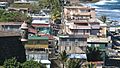
Top of homes in La Perla
-
Residences in La Perla
-

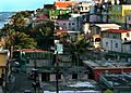
La Perla neighborhood in San Juan
-
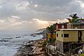
La Perla coastline in 2018
-

La Perla from the sea in 2012
-
Youth playing basketball at a court at La Perla


See also
 In Spanish: La Perla (San Juan, Puerto Rico) para niños
