
Lake Chad facts for kids
Quick facts for kids Lake Chad |
|
|---|---|
 |
|
| Location | Sahelian zone at the conjunction of Chad, Cameroon, Nigeria, and Niger |
| Primary inflows | Chari River, Yobe River, Ngadda River |
| Primary outflows | Bahr el-Ghazal |
| Basin countries | Chad, Cameroon, Nigeria, Niger |
| Surface area | 2,000 km2 (770 sq mi) |
| Max. depth | 2 m (6.6 ft) |
| Islands | Bogomerom Archipelago |
| Settlements |
|
| Official name: Lac Tchad | |
| Designated: | 17 June 2001 |
| Reference #: | 1072 |
| Official name: Partie tchadienne du lac Tchad | |
| Designated: | 14 August 2001 |
| Reference #: | 1134 |
| Official name: Lake Chad Wetlands in Nigeria | |
| Designated: | 30 April 2008 |
| Reference #: | 1749 |
| Official name: Partie Camerounaise du Lac Tchad | |
| Designated: | 2 February 2010 |
| Reference #: | 1903 |
Lake Chad (Arabic: بحيرة تشاد, Kanuri: Sádǝ, French: Lac Tchad) is an endorheic freshwater lake located at the junction of four countries: Nigeria, Niger, Chad, and Cameroon in western and central Africa respectively. It is also an important wetland ecosystem in West-Central Africa. The catchment area of Lake Chad is 1 million square kilometres (390,000 sq mi). In the 19th century, Lake Chad was substantially larger with an area of 28,000 square kilometres (11,000 sq mi). However, due to climate change and human water diversion, Lake Chad has been greatly reduced since the mid-1970s, and its area has fluctuated between 2,000 and 5,000 square kilometres (770 and 1,930 sq mi).
History

The Chad Basin was formed by the depression of the African Shield, and Lake Chad, located in the center of the basin, was once a sea in the Quaternary period. Its area experienced four heydays between 39,000 BC and 300 BC, leaving thick diatomaceous earth and lacustrine deposits in the strata. This has been called Mega-lake Chad or lake Mega-Chad. The largest area, according to research from the Shuttle Radar Topographic Mission data, was about 340,400 square kilometres (131,400 sq mi), with a volume of about 13,500 cubic kilometres (3,200 cu mi), a maximum depth of about 160 metres (520 ft) and the lake surface about 325 metres (1,066 ft) AMSL. When the level was at this height, it flowed into the Benue River through the Mayo Kébbi, and finally flows into the Atlantic Ocean through the Niger River.
The Lake Chad area was settled as early as 500 BC, and major archaeological discoveries include the Sao civilization. According to the records of Claudius Ptolemy, the Roman general Septimius Flaccus led an expedition to the Sahara Desert in 50 AD, crossed the Tibesti Mountains, and reached the north of Lake Chad, known as "Hippo and Rhino Lake". The merchant Julius Maternus led an expedition through the same route around 83 AD and brought a rhino back to Rome from Lake Chad. Kingdoms arose around Lake Chad during the early Middle Ages. Arab settlement began in the 16th century, as Fulani herdsmen now move seasonally into the Lake Chad lowlands, and Hausa farming communities also settled around the lake.
Following the growing interest in Africa among European academic and business communities, the Lake Chad area was extensively described by Europeans in the 19th century. Gustav Nachtigal of Prussia carried a gift from the King of Prussia and established connections with the rulers of the Bornu Empire on the shores of Lake Chad; Hanns Vischer of Switzerland crossed the Sahara Desert with a camera and arrived at Lake Chad, taking a large number of photos; Boyd Alexander of Britain completed an exploration journey from the Atlantic to the Red Sea in order to explore the relationship between the Niger River, Lake Chad, and the Nile River. By the second decade of the 20th century, Lake Chad had been colonized and occupied by Britain, France, and Germany.
Geography

The Lake Chad Basin is an extensional fault depression type rift basin, which can be divided into four secondary structural units: southern depression, northern depression, central uplift, and eastern slope. The southern depression of the basin is characterized by an asymmetric fault depression composite rift with steep slopes in the east and gentle slopes in the west on the profile, and is distributed in an NNW direction on the plane. There are two large basin‐bounding normal fault developed on both sides of the basin, with a graben style fault and depression in the middle. The east and west sides are outward dipping low angle gentle slope areas. The eastern boundary fault is steep with a dip angle of about 55 °, while the western fault has a dip angle of about 45 °. The overall thickness of the inner layer in the slope area is relatively thin. In the central area of the basin, the thickness of the sedimentary strata is large, and the thickness of the sedimentary center zone reaches over 10,000 metres (33,000 ft). The northern part of the basin appears steep in the west and gentle in the east on the profile. Five fault structural zones parallel to the basin‐bounding faults have developed from west to east.
Lake Chad is divided into north and south parts by a shallow sill called the Great Barrier, with the bottom of the northern basin at an altitude of 275.3 metres (903 ft) and the bottom of the southern basin at 278.2 metres (913 ft). When the water level in the south exceeds 279 metres (915 ft) above sea level, it will flow into the north. In the south, there is continuous open water at the mouth of the Shali River, and the western part of the water is covered by reed swamps, and the sand dunes that are not completely submerged in the eastern waters form an archipelago. The average depth of the southern lake basin is between .5 and 2 metres (1.6 and 6.6 ft), that of the northern lake basin is between 0 and 1.8 metres (5.9 ft), and that of the eastern archipelago is between 0 and 2 metres (6.6 ft).
The climate of the Lake Chad region is strongly influenced by continental and maritime air masses. The maritime air mass moves northward during the summer, producing seasonal precipitation. In late summer, continental air mass dominate again. The average annual precipitation in the Lake Chad area is 330 mm, with an average annual precipitation of 560 mm on the south bank and about 250 mm on the north bank. The highest temperature in the rainy season is 30 °C, and the highest temperature rises to more than 32 °C when October and November enter the dry season. The temperature difference between day and night is almost twice that of the rainy season, and the lowest nighttime temperature sometimes drops to 8 °C in December and January. April is usually the hottest month of the year, with temperatures occasionally reaching 40 °C, the lowest water levels appear in June to July, and the highest water levels in November to December, with surface water temperatures ranging from 19 °C to 32 °C.
Hydrology

The Lake Chad basin covers an area of about 1 million square kilometres (390,000 sq mi), and is injected by the Shari River, Engada River, and Yobe River. The water supply of the lake is seasonal. Most of the precipitation comes from the Adamawa Plateau in the south of the basin, which is transported to the lake basin through the Chari River and the Logone River. The two contribute 95% of the total inflow of Lake Chad, while the Yobe River only contributes less than 2.5%. The lake seeps through the underground to the Bodélé Depression, about 400 kilometres to the north-east, taking away most of the salinity and keeping the salinity of Lake Chad low, with the southwest being freshwater and the north-east, which has the highest salinity, only slightly salty.
The water volume of most large lakes in Africa depends on rainfall and evaporation, which means that temperature and precipitation are crucial for regulating the water balance of these bodies of water, and any fluctuations can cause significant changes in their water level and area. Lake Chad is a shallow inland lake, and the rainfall in the Lake Chad basin is very sensitive to small changes in atmospheric circulation, so the surface area of Lake Chad is greatly affected by climate change. Dry climate due to vegetation loss from overgrazing and deforestation and large-scale irrigation projects that diverted water from the rivers that feed the lake are the main reasons for the shrinkage of Lake Chad. the Atlantic multidecadal oscillation and the El Niño–Southern Oscillation have affected precipitation in the Sahel region. From the early 1960s to the mid-1980s, the lake water level decreased by 3 metres (9.8 ft) compared to the average level from 1900 to 2010.
In 1870, the area of Lake Chad was about 28,000 square kilometres (11,000 sq mi). The lake was able to flow out of the Bahr el-Ghazal during the rainy season. At the turn of the 20th century the area of Lake Chad shrank briefly, and reached a new high in the middle of the 20th century and overflowed from the Bahr el-Ghazal again. A major drought started in the Sahel region in the late 1960s and caused severe damage in 1972 and 1984. It was thought to be related to vegetation loss, global warming, and sea surface temperature anomalies. During this period, Lake Chad shrunk considerably and fluctuated in the range of 2,000 to 5,000 square kilometres (770 to 1,930 sq mi) thereafter.
From June 1966 to January 1973, the area of Lake Chad shrank from 22,772 square kilometres (8,792 sq mi) to 15,400 square kilometres (5,900 sq mi), further shrunk to 4,398 square kilometres (1,698 sq mi) in 1975, and only 1,756 square kilometres (678 sq mi) in February 1994. Since then, the area of Lake Chad has entered a relatively stable stage with a slight increase. From 1995 to 1998, it fluctuated within the range of 1,200 to 4,500 square kilometres (460 to 1,740 sq mi). The area once reached 5,075 square kilometres (1,959 sq mi) in 2000, and the average area of surface water from 2013 to 2016 was about 1,876 square kilometres (724 sq mi), with the largest area being 2,231 square kilometres (861 sq mi) in July 2015.
Ecology

Part of the Lake Chad Basin is located within the Chad Basin National Park in Nigeria, and the country and Cameroon have established the Lake Chad Ramsar Wetland with a total area of 8,225 km2. The wetland plants in the south mainly include cyperus papyrus, etc. Reeds mainly grow in the north where the salinity is high, and the floating plant pistia sometimes covers large areas of open water. Plants such as hyparrhenia rufa grow on the shores of lakes with long floods in the south. The area of permanent vegetation has increased from about 3,800 square kilometres (1,500 sq mi) in 2000 to about 5,200 square kilometres (2,000 sq mi) in 2020 as water levels have dropped and temperatures have increased. The surrounding dense woodland has been converted to open forest with acacias, baobabs, palms and Indian jujube.
Lake Chad is permanently or seasonally inhabited by hundreds of species of birds such as northern shoveler, Egyptian goose and marabou stork. It is an important wintering ground for European anatididae and wading birds. There are raptors such as steppe eagle and booted eagle on the lakeshore, and more than one million ruff can be observed on the lake at one time. The once common large mammals include red-fronted gazelle, dama gazelle, patas monkey, striped hyena, cheetah and caracal, while African elephant, otter, hippopotamus, sitatunga and kob are distributed in the wetlands. At present, most of the large mammals have been hunted to extinction, replaced by a large number of cattle.
The entire Lake Chad Basin has 179 species of fish, of which 127 are the same as the Niger River Basin, 85 are the same as the Nile River Basin, 47 are the same as the Congo River Basin, and 84 fish species are distributed in the lake. This makes it a rich fishing ground for communities across Nigeria, Niger, Chad, and Cameroon. The seasonal influx of floods combined with seasonal increases in air temperature leads to decreased salinity, increased turbidity, and increased trophic levels, which catalyzed a surge in the number of phytoplankton and zooplankton, allowing large fish to migrate seasonally within the watershed to feed and breed in the fertile floodplain when floods arrive.
Development


Local self-sufficient crops include sorghum, maize, finger millet, beans, and vegetables. Gourd is widely planted for making utensils. The collection of forest products such as gum arabic, honey, beeswax, and firewood is of great significance in the region. However, the reduction in forest area has had a negative impact on the production of these products, and the explosive growth of cattle herds has exacerbated this impact. Cattle are the most important livestock raised, as well as poultry, goats, sheep, camels, horses, and donkeys. The livestock industry was severely affected by the droughts of the 1970s and 1980s. Fishing has traditionally been the most important economic activity for the people of the lake area, which almost ceased during drought periods and only resumed in the mid-1990s. Most fishing products are dried, pickled, or smoked. The natron produced in the depression on the northeast bank of the lake has long been of significant economic significance. Traditionally, it has been excavated in blocks and transported across the lake to enter the Nigerian market.
There are more than 30 million residents in the Chad Lake Basin. There are more than 70 ethnic groups around the lake, most of whom are distributed on the south bank, where the population density exceeds 100 inhabitants per square kilometre (260/sq mi). They rely on the water source of Chad Lake for irrigation, breeding, animal husbandry and drinking. Since the drought in the 1970s, the soil that can be planted without irrigation and fertilization has been exposed at the bottom of the lake, and it has been reclaimed as a polder for planting maize, cowpea, rice, sorghum and other crops. Farmers have shifted from planting mainly dry crops, such as wheat, to rice with high water demand, resulting in more serious soil salinization and water eutrophication.
Since 1970, five countries in the southern part of the basin have constructed numerous water conservancy projects in the upper reaches of the Chari River, Logone River, and Yobe River to intercept river water, resulting in a sharp decrease in the amount of water entering the lake. The average annual inflow of the Chari River and the Logone River from 1970 to 1990 was only 55% of that from 1950 to 1970. Since the 1980s, one-third of the water in the Chari River and the Logone River has been diverted and intercepted by the Central African Republic located upstream for agricultural irrigation and hydroelectric power generation. The dams built on the upper reaches of the rivers entering the lake changed the time and scope of seasonal floods and disrupted the migration of fish, resulting in a sharp reduction in the populations of Alestes baremoze and Nile perch, the main catches of Lake Chad, and a significant reduction in the catch. At the same time, the conflicts between countries and ethnic groups competing for water and land are also escalating. The four countries along the lake are all facing the problem of extreme poverty.
Cameroon, Niger, Nigeria, and Chad established the Lake Chad Basin Commission on 22 May 1964. The Central African Republic joined in 1996, and Libya joined in 2008. The headquarters of the committee is located in N'Djamena, Chad. The commission's tasks include managing Lake Chad and its water resources, protecting the ecosystem, and promoting regional integration, peace, security, and development in the Lake Chad region. The surrounding countries' water replenishment plan for Lake Chad includes the construction of a 2,400 kilometres (1,500 mi) canal to transport 100 billion cubic metres (130×109 cu yd) of water from the Congo River Basin to the Chari River Basin every year, and use a series of dams along the route to generate electricity.
Images for kids
-
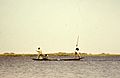
Kanuri tribal fishermen in 1970s
-
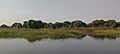
Shore of Lake Chad
-
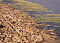
A town on the shores of Lake Chad

.jpg)

See also
 In Spanish: Lago Chad para niños
