
Lake Mead facts for kids
Quick facts for kids Lake Mead |
|
|---|---|
 |
|

Lake Mead
Location in Nevada

Lake Mead
Location in the United States
|
|
| Location | Clark County, Nevada and Mohave County, Arizona |
| Coordinates | 36°15′N 114°23′W / 36.25°N 114.39°W |
| Lake type | Reservoir |
| Primary inflows | Colorado River |
| Primary outflows | Colorado River |
| Basin countries | United States |
| First flooded | September 30, 1935 by the Hoover Dam |
| Max. length | 120 mi (190 km) |
| Surface area | 247 sq mi (640 km2) |
| Max. depth | 532 ft (162 m) |
| Water volume | Maximum: 26,134,000 acre⋅ft (32.236 km3) |
| Shore length1 | 759 mi (1,221 km) |
| Surface elevation | Maximum: 1,229 ft (375 m) |
| 1 Shore length is not a well-defined measure. | |
Lake Mead is a reservoir formed by the Hoover Dam on the Colorado River in the Southwestern United States. It is located in the states of Nevada and Arizona, 24 mi (39 km) east of Las Vegas. It is the largest reservoir in the US in terms of water capacity. Lake Mead provides water to the states of Arizona, California, and Nevada as well as some of Mexico, providing sustenance to nearly 20 million people and large areas of farmland.
At maximum capacity, Lake Mead is 112 miles (180 km) long and 532 feet (162 m) at its greatest depth. Lake Mead has a surface elevation of 1,229 feet (375 m) above sea level. The surface area is 247 square miles (640 km2), and Lake Mead contains 28.23 million acre-feet (34,820,000 megaliters) of water.
The lake has remained below full capacity since 1983 due to drought and increased water demand. As of 16 March 2022[update], Lake Mead held 31.01% of full capacity at 8.753 million acre-feet (10,797,000 megaliters), dropping below the reservoir's previous all-time low of 9.328 million acre-feet (11,506,000 megaliters) recorded in July 2016. In a draft 2022 Colorado River annual operating plan, released by the U.S. Bureau of Reclamation, a "Shortage Condition" is expected to be declared for 2022, due to the lake level falling below 1,075 feet (327.7 m), which will result in a projected 4.44% curtailment in downstream water delivery.
Contents
History

The lake was named after Elwood Mead (January 16, 1858 – January 26, 1936), who was the commissioner of the U.S. Bureau of Reclamation from 1924 to 1936 during the planning and construction of the Boulder Canyon Project that created the dam and lake. Lake Mead was established as the Boulder Dam Recreation Area in 1936, administrated by the National Park Service. The name was changed to the Lake Mead National Recreation Area in 1964, and Lake Mohave and the Shivwits Plateau were added to its jurisdiction. Both lakes and the surrounding area offer year-round recreation options.
The accumulated water from Hoover Dam forced the evacuation of several communities, most notably St. Thomas, Nevada, whose last resident left the town in 1938. The ruins of St. Thomas are sometimes visible when the water level in Lake Mead drops below normal. Lake Mead also covered the sites of the Colorado River landings of Callville and Rioville and the river crossing of Bonelli's Ferry.
At lower water levels, a high-water mark or "bathtub ring" is visible in photos that show the shoreline of Lake Mead. The bathtub ring is white because of the deposition of minerals on previously submerged surfaces.
Geography


Nine main access points to the lake are available. On the west are three roads from the Las Vegas metropolitan area. Access from the northwest from Interstate 15 is through the Valley of Fire State Park and the Moapa River Indian Reservation to the Overton Arm of the lake.
The lake is divided into several bodies. The large body closest to the Hoover Dam is Boulder Basin. The narrow channel, which was once known as Boulder Canyon and is now known as The Narrows, connects Boulder Basin to Virgin Basin to the east. The Virgin River and Muddy River empty into the Overton Arm, which is connected to the northern part of the Virgin Basin. The next basin to the east is Temple Basin, and following that is Gregg Basin, which is connected to the Temple Basin by the Virgin Canyon. When the lake levels are high enough, a section of the lake farther upstream from the Gregg Basin is flooded, which includes Grand Wash Bay, the Pearce Ferry Bay and launch ramp, and about 55 miles (89 km) of the Colorado River within the lower Grand Canyon, extending to the foot of 240 Mile Rapids (north of Peach Springs, Arizona). In addition, two small basins, the Muddy River Inlet and the Virgin River Basin, are flooded when the lake is high enough where these two rivers flow into the lake. As of February 2015, these basins remain dry.
Jagged mountain ranges surround the lake, offering a scenic backdrop, especially at sunset. Two mountain ranges are within view of the Boulder Basin, the River Mountains, oriented northwest to southeast and the Muddy Mountains, oriented west to northeast. Bonelli Peak lies to the east of the Virgin Basin.
Las Vegas Bay is the terminus for the Las Vegas Wash which is the sole outflow from the Las Vegas Valley.
Drought and water usage issues
Lake Mead receives the majority of its water from snow melt in the Colorado, Wyoming, and Utah Rocky Mountains. Inflows to the lake are largely moderated by the upstream Glen Canyon Dam, which is required to release 8.23 million acre-feet (10.15 km3) of water each year to Lake Mead. Hoover Dam is required to release 9 million acre-feet (11 km3) of water each year, with the difference made up by tributaries that join the Colorado below Glen Canyon or flow into Lake Mead. Outflow, which includes evaporation and delivery to Arizona, California, Nevada, and Mexico from Lake Mead are generally in the range of 9.5 to 9.7 million acre-feet (11.7 to 12.0 km3), resulting in a net annual deficit of about 1.2 million acre-feet (1.5 km3).
Before the filling of Lake Powell (a reservoir of similar size to Lake Mead) behind Glen Canyon Dam, the Colorado River flowed largely unregulated into Lake Mead, making Mead more vulnerable to drought. From 1953 to 1956, the water level fell from 1,200 to 1,085 feet (366 to 331 m). During the filling of Lake Powell from 1963 to 1965, the water level fell from 1,205 to 1,090 feet (367 to 332 m). Multiple wet years from the 1970s to the 1990s filled both lakes to capacity, reaching a record high of 1225 feet in the summer of 1983. In these decades prior to 2000, Glen Canyon Dam frequently released more than the required 8.23 million acre-feet (10.15 km3) to Lake Mead each year, allowing Lake Mead to maintain a high water level despite releasing significantly more water than for which it is contracted. However, since 2000, the Colorado River has experienced persistent drought, with average or above-average conditions occurring in only five years (2005, 2008–2009, 2011 and 2014) in the first 14 years of the 21st century. Although Glen Canyon was able to meet its required minimum release until 2014, the water level in Lake Mead has steadily declined due to the loss of the surplus water that once made up for the annual overdraft.

In June 2010, the lake was at 39% of its capacity, and on Nov. 30, 2010, it reached 1,081.94 ft (329.78 m), setting a new record monthly low. From mid-May 2011 to January 22, 2012, Lake Mead's water elevation increased from 1,095.5 to 1,134.52 feet (333.91 to 345.80 m), after a heavy snowmelt in the Rocky Mountains prompted the release of an extra 3.3 million acre-feet (4.1 km3) from Glen Canyon into Lake Mead.
In 2012 and 2013, the Colorado River basin experienced its worst consecutive water years on record, prompting a low Glen Canyon release in 2014 – the lowest since 1963, during the initial filling of Lake Powell – in the interest of recovering the level of the upstream reservoir, which had fallen to less than 40% capacity as a result of the drought. Consequently, Lake Mead has fallen significantly, reaching a new record low each subsequent year starting in 2014. In 2014, its record low was 1,081.82 feet (329.74 m) on July 10, 2014. On June 23, 2015, Lake Mead reached another new record low when it briefly fell below 1,075.0 feet (327.7 m), the first official "drought trigger" elevation, for the first time since the lake was filled. If the lake is at this elevation or lower at the beginning of the water year (October 1), an official shortage declaration by the Bureau of Reclamation will enforce water rationing in Arizona and Nevada.
Lake Mead's water level rebounded a few feet by October 2015 and avoided triggering the drought restrictions. However, the water level starting falling in Spring 2016 and fell below the drought trigger level of 1,075 feet again in May 2016. Beginning on May 18, 2016, Lake Mead started reaching new record lows almost every subsequent day. It fell below 1,074.0 feet (327.4 m) for the first time on May 31, 2016, and below 1,073.0 feet (327.1 m) for the first time on June 9, 2016. It fell to a new record low of 1,071.61 feet (326.63 m) on July 1, 2016 before beginning to rebound slowly. Drought restrictions were avoided again when the lake level rose above 1,075 feet on August 29, 2016.
As a result of the decreasing water level, marinas and boat launch ramps have either had to be relocated to another area of the lake or have closed down permanently. The Las Vegas Bay Marina was relocated in 2002 and the Lake Mead Marina was relocated in 2008 to Hemenway Harbor. Overton Marina has been closed due to low levels in the northern part of the Overton Arm. Government Wash, Las Vegas Bay, and Pearce Ferry boat launch ramps have also been closed. Las Vegas Boat Harbor and Lake Mead Marina in Hemenway Harbor/Horsepower Cove remain open, along with Callville Bay Marina, Echo Bay Marina, Temple Bar Marina, Boulder Launch Area (former location of the Lake Mead Marina) and the South Cove launch ramp.
Changing rainfall patterns, climate variability, high levels of evaporation, reduced snow melt runoff, and current water use patterns are putting pressure on water management resources at Lake Mead as the population relying on it for water and the Hoover Dam for electricity continue to increase.
Hoover Dam would cease generating electricity if the water level falls below 950 feet and the lake will stabilize at a level of 895 feet (273 m) when the water reaches the lowest water outlet of the dam. In order to ensure that the city of Las Vegas will continue to be able to draw its drinking water from Lake Mead, nearly $1.5 billion was spent on building a new water intake tunnel in the middle of the lake at the elevation of 860 feet. The 3-mile tunnel took seven years to build under the lake and was put into operation in late 2015.
Recreation and marinas
Lake Mead provides many types of recreation to locals and visitors. Boating is the most popular. Additional activities include fishing, water skiing, swimming, and sunbathing. Four marinas are located on Lake Mead, which include Las Vegas Boat Harbor and Lake Mead Marina (Hemenway Harbor NV) operated by the Gripentogs, and Callville Bay (Callville Bay NV) and Temple Bar (Arizona), both operated by Forever Resorts. The area also has many coves with rocky cliffs and sandy beaches. Several small to medium-sized islands occur in the lake area depending on the water level. In addition, the Alan Bible Visitor Center hosts the Alan Bible Botanical Garden, a small garden of cactus and other plants native to the Mojave Desert.
B-29 crash
At the bottom of the lake is a Boeing B-29 Superfortress that crashed in 1948 while testing a prototype missile guidance system known as "suntracker".
The wreckages of at least two smaller airplanes are also within Lake Mead.
Images for kids
-
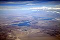
Aerial view of Lake Mead in August 2010.
-
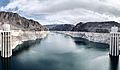
Lake Mead in October 2021, as seen from the Hoover Dam with the white band showing the high water level.
-
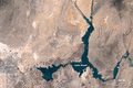
A comparison of Lake Mead water levels from July 2000 to July 2015.


See also
 In Spanish: Lago Mead para niños
