
Lake Mohawk, New Jersey facts for kids
Quick facts for kids
Lake Mohawk, New Jersey
|
|
|---|---|

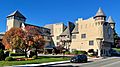
White Deer Plaza Business District
|
|

Map of Lake Mohawk in Sussex County. Inset: Location of Sussex County in New Jersey.
|
|
| Country | |
| State | |
| County | |
| Area | |
| • Total | 6.172 sq mi (15.987 km2) |
| • Land | 5.005 sq mi (12.964 km2) |
| • Water | 1.167 sq mi (3.023 km2) 18.91% |
| Elevation | 869 ft (265 m) |
| Population
(2010 census)
|
|
| • Total | 9,916 |
| • Density | 1,981.1/sq mi (764.9/km2) |
| Time zone | UTC-5 (Eastern (EST)) |
| • Summer (DST) | UTC-4 (Eastern (EDT)) |
| Area code(s) | 862/973 |
| FIPS code | 3415610 |
| GNIS feature ID | 02389370 |
Lake Mohawk is an unincorporated residential development and census-designated place (CDP) split between Byram Township and Sparta Township, in Sussex County, New Jersey, United States. As of the 2010 United States census, the CDP's population was 9,916, of which 1,824 were in Byram Township and 8,092 in Sparta Township.
Geography
According to the United States Census Bureau, the CDP had a total area of 6.172 square miles (15.987 km2), including 5.005 square miles (12.964 km2) of land and 1.167 square miles (3.023 km2) of water (18.91%).
The community is located around Lake Mohawk, the largest artificial body of water in the state of New Jersey that is a private lake. There is the main lake in the mountains of the community and the Alpine Pool, both of which are spring fed. The water for the Alpine Pool cascades down gracefully from a spring that rises from an even higher peak in the mountains. An alpine motif was used throughout the community.
Community
The buildings in the tiny town center resemble little castles, or reflect alpine architectural styles. This distinctive architecture in the town center and of many homes was a major aspect of the listing of Lake Mohawk on the National Register of Historic Places. The town center has restaurants, a post office, and limited shop, service, or professional space. This area is called White Deer Plaza after a Native American who lent her name to the center. A tiered boardwalk was constructed along the northern edge of the lake where the town center exists. A country club dominates the boardwalk near the dam at the waterfall at the outlet which is the source of the Wallkill River that created the lake. The river flows out of the lake in a northerly direction. A landing was provided along the Lake Mohawk Boardwalk that Lake Mohawk residents may use to tie up to a dock while visiting the Country Club facilities. There is an outside restaurant that is open from Memorial day to Labor day for members of Lake Mohawk only. Special events are scheduled to keep the children and teens involved. Annual events the Beer and Wine Tasting, German Christmas Market, Holiday Tree Lighting, Easter and Mothers Day buffet, 4 July Buffet and Fireworks.
In the 1950s a movie theater, a stone's throw beyond the main entrance to the lake, called Winona Parkway, was built along the adjacent county roadway, route 15, which leads to the Dutch colonial and revolutionary era mining town of Sparta. The Central Hotel in Sparta drew as many diners for its pizza as did Krogh's Restaurant and the St. Moritz for its finer fare on the plaza overlooking the lake. Some residents would travel to Perona Farms in nearby Andover. Fresh vegetables were sold from the gardens of a nearby Abby that developed a white corn strain called, Luther Hill Corn, the likes of which were never sold in a grocery store. The cob was about six inches long with jagged rows of tiny kernels that needed no butter for full enjoyment.
| Lake Mohawk | |
|---|---|
| Location | Sussex County, New Jersey |
| Coordinates | 41°01′58″N 74°38′37″W / 41.032875°N 74.643494°W |
| Lake type | Reservoir |
| Primary inflows | Unnamed streams |
| Primary outflows | Wallkill River |
| Basin countries | United States |
| Surface elevation | 725 ft (221 m) |
| Settlements | Lake Mohawk |
Beaches are provided along the edge of the lakes, spaced to enable residents of Lake Mohawk to walk to the nearest one. Membership in the club is required for owners and renters alike. An issue of exclusion was raised at one point legally, but membership remains a requirement for residents. An attended gated area, resembling castle turrets, exists on the western "trail", which leads to the homes on the islands and along the western shore. A golf course located along the western drive is part of the country club.
Except for the Alpine Pool and the main lake areas that are accessible from an entrance high in the mountains, all of the community is reached by descending from the surrounding mountains of Sussex County. Homes have been built up each face of the enclosing mountains, but the roads to them are accessed only from the main road around the lake. From the Alpine Pool, a panoramic view of the county is possible. On one side almost the entire stretch of the main lake is visible and on the other, the mountains that reach into the states of Pennsylvania and New York.
At the southern end of the lake is a swimming pool and tennis complex originally called the "Marine Pool", that is constructed to resemble the deck of an ocean liner. It is modeled after the likes of SS Normandie, having all of the appointments of a cruise ship, with a galley motif for the restaurant and a great stand of stadium seating with colorful backs for the spectators at swimming events held at the facility. Through the seating is a stairway to the captain's quarters where the managers and lifeguards have quarters and stow special equipment.
The pool is ozone filtered, without a drop of chlorine in the water, and was the first pool in the United States to use Corona Discharge (CD) Ozone to treat its water. The filter system, built in 1937, was designed to resemble the engine room of the ship. The pool is Olympic-size (50m, with eight lanes) and has a central tower for diving events. The depth of the pool at that portion is ten feet. Both ends of the pool are more shallow, with a kiddie section nearest the tennis courts. On the northern end of the pool near the galley, there used to be a giant water slide that had been featured in television commercials for Zest soap in the 1960s. Beyond the pool to the south are three asphalt tennis courts, with another set of three clay courts in the parking area.
Swimming events at the pool are AAU competitions in all aquatic categories. Celebrities such as Buster Crabbe and Esther Williams were normal fare at the events in the 1940s and 1950s. This was a time when the youngsters of the community could hitch-hike rides along the road from their neighbors without concern.
In the 1940s and 1950s there was an "Indian village" with a souvenir shop, located along the opposite shore of the southern end of the lake that added another attraction depicted in postcards of the day. [1] The development of Lake Mohawk was referred to as a "reservation" in most promotional materials to continue the Indian tribe imagery.
Many of the homes along the water have boathouses and docks. Sail boats and motor boats are a popular way to get around the lake. The "Marine Base", a marina built in the style of the country club, is located at a midpoint along the lake on the eastern shore.
The community used to be composed of summer residences. Few lived there around the year. Many houses were not insulated, nor did they have heating beyond a fireplace for especially cool summer nights. Among those who stayed year-round, friends would be hosted for the snowy holidays and winter sports. Driving across the frozen lake was shorter and safer than trying to traverse the steep hills. Even delivery trucks would make the short trip across the ice.
The seasonal residents of the early years included many who showed horses in the English-style regional circuits. Hunters, open-jumpers, and three- and five-gated saddle horses competed in the events. The Lake Mohawk Horse Show drew competitors from New York and Pennsylvania as well as New Jersey. The professional photographer who traveled from show to show along with the competitors throughout the season, maintained his office in Lake Mohawk at a little castle structure opposite the club house. Photographs of the competitors, judges, and winners were available from his files, selected from proofs sent to the subjects or from displays he set up at later shows.
Before the community was created, the area that is today Lake Mohawk was known as "Brogden's Meadow." A 600-foot dam on the Wallkill River was begun in 1926. The lake was filled in 1928. The dam was privately constructed by the developers Arthur D. Crane and Herbert L. Closs. They controlled the development, sales, and rentals of the entire community.
Soon after the construction of the lake, in the mid- to late 1930s, one of the architects was staying with his family in a seaplane on the lake. A fire broke out on the seaplane. While they escaped by boat, the plane sank to the bottom of the lake. In the late 1990s an Italian team attempted salvage, but according to their reports, the wreck was too deteriorated to be recovered.
The route to Lake Mohawk was a winding drive up and down through a shady rural and mountainous roadside until after the completion of Interstate Highways connecting the area to the New York metropolitan area. After those high speed connections were established nearby into the county, the community took on a year-round population of entertainers, airline employees and pilots, as well as commuters.
Demographics
| Historical population | |||
|---|---|---|---|
| Census | Pop. | %± | |
| 1960 | 4,647 | — | |
| 1970 | 6,262 | 34.8% | |
| 1980 | 8,498 | 35.7% | |
| 1990 | 8,930 | 5.1% | |
| 2000 | 9,755 | 9.2% | |
| 2010 | 9,916 | 1.7% | |
| Population sources: 1960-1980 1990-2010 2000 2010 |
|||
Census 2010
As of the census of 2010, there were 9,916 people, 3,768 households, and 2,769 families residing in the CDP. The population density was 1,981.1 per square mile (764.9/km2). There were 4,100 housing units at an average density of 819.1 per square mile (316.3/km2)*. The racial makeup of the CDP was 95.91% (9,510) White, 0.61% (60) Black or African American, 0.05% (5) Native American, 1.52% (151) Asian, 0.00% (0) Pacific Islander, 0.44% (44) from other races, and 1.47% (146) from two or more races. [[Hispanic (U.S. Census)|Hispanic or Latino of any race were 4.77% (473) of the population.
There were 3,768 households out of which 35.9% had children under the age of 18 living with them, 62.9% were married couples living together, 7.3% had a female householder with no husband present, and 26.5% were non-families. 22.4% of all households were made up of individuals, and 11.4% had someone living alone who was 65 years of age or older. The average household size was 2.62 and the average family size was 3.12.
In the CDP, the population was spread out with 26.4% under the age of 18, 5.6% from 18 to 24, 22.3% from 25 to 44, 32.1% from 45 to 64, and 13.7% who were 65 years of age or older. The median age was 42.7 years. For every 100 females there were 92.3 males. For every 100 females ages 18 and old there were 90.3 males.
Census 2000
As of the 2000 United States census there were 9,755 people, 3,692 households, and 2,787 families residing in the CDP. The population density was 1,951.2 people per square mile (753.3/km2). There were 3,940 housing units at an average density of 788.1/sq mi (304.2/km2). The racial makeup of the CDP was 96.88% White, 0.38% African American, 0.09% Native American, 1.11% Asian, 0.04% Pacific Islander, 0.44% from other races, and 1.06% from two or more races. Hispanic or Latino of any race were 2.53% of the population.
There were 3,692 households, out of which 38.2% had children under the age of 18 living with them, 66.9% were married couples living together, 6.8% had a female householder with no husband present, and 24.5% were non-families. 20.8% of all households were made up of individuals, and 10.1% had someone living alone who was 65 years of age or older. The average household size was 2.64 and the average family size was 3.09.
In the CDP the population was spread out, with 27.7% under the age of 18, 4.1% from 18 to 24, 30.3% from 25 to 44, 27.2% from 45 to 64, and 10.8% who were 65 years of age or older. The median age was 39 years. For every 100 females, there were 92.9 males. For every 100 females age 18 and over, there were 91.1 males.
The median income for a household in the CDP was $81,699, and the median income for a family was $95,621. Males had a median income of $72,279 versus $40,417 for females. The per capita income for the CDP was $35,637. About 0.8% of families and 1.7% of the population were below the poverty line, including 0.8% of those under age 18 and 3.4% of those age 65 or over.
Images for kids
-
Lake Mohawk Country Club

See also
 In Spanish: Lake Mohawk para niños
