
Lanai City, Hawaii facts for kids
Quick facts for kids
Lanai City, Hawaii
Lānaʻi City
|
|
|---|---|

Lanai City
|
|

Location in Maui County and the state of Hawaii
|
|
| Country | United States |
| State | Hawaii |
| County | Maui |
| Area | |
| • Total | 6.77 sq mi (17.53 km2) |
| • Land | 6.77 sq mi (17.53 km2) |
| • Water | 0.00 sq mi (0.00 km2) |
| Elevation | 1,644 ft (501 m) |
| Population
(2020)
|
|
| • Total | 3,332 |
| • Density | 492.39/sq mi (190.10/km2) |
| Time zone | UTC-10 |
| ZIP code |
96763
|
| Area code(s) | 808 |
| FIPS code | 15-43700 |
| GNIS feature ID | 0361713 |
Lanai City is a census-designated place (CDP) on the island of Lanai, in Maui County, Hawaii, United States. The population was 3,332 at the 2020 census. Lanai City is the island's commercial center. Many of the island's restaurants and shops are in the town square that surrounds Dole Park, and the only hospital on the island, Lanai Community Hospital, is located near the park.
Lanai City is served by Lanai Airport (LNY).
Geography and climate
Lanai City is located at 20°49′39″N 156°55′19″W / 20.82750°N 156.92194°W (20.827574, −156.921912).
According to the United States Census Bureau, the CDP has a total area of 6.9 square miles (17.9 km2), all land.
Lanai City experiences a tropical savanna climate (Köppen classification As) with a mostly dry summer season. The average temperature in January is almost cold enough to qualify this climate as a warm form of a Mediterranean climate (Köppen climate classification Csa). An average monthly temperature of 18 °C is the lower limit for tropical climate classification.
| Climate data for Lanai City | |||||||||||||
|---|---|---|---|---|---|---|---|---|---|---|---|---|---|
| Month | Jan | Feb | Mar | Apr | May | Jun | Jul | Aug | Sep | Oct | Nov | Dec | Year |
| Record high °F (°C) | 82 (28) |
82 (28) |
86 (30) |
87 (31) |
86 (30) |
86 (30) |
86 (30) |
87 (31) |
89 (32) |
92 (33) |
85 (29) |
85 (29) |
92 (33) |
| Average high °F (°C) | 72.0 (22.2) |
72.8 (22.7) |
72.9 (22.7) |
73.7 (23.2) |
74.7 (23.7) |
76.2 (24.6) |
76.8 (24.9) |
78.1 (25.6) |
78.5 (25.8) |
77.4 (25.2) |
75.8 (24.3) |
73.6 (23.1) |
75.2 (24.0) |
| Daily mean °F (°C) | 65.9 (18.8) |
66.0 (18.9) |
66.6 (19.2) |
67.5 (19.7) |
68.4 (20.2) |
70.2 (21.2) |
71.1 (21.7) |
72.1 (22.3) |
72.2 (22.3) |
71.2 (21.8) |
69.7 (20.9) |
67.5 (19.7) |
69.0 (20.6) |
| Average low °F (°C) | 59.7 (15.4) |
59.2 (15.1) |
60.3 (15.7) |
61.3 (16.3) |
62.1 (16.7) |
64.2 (17.9) |
65.3 (18.5) |
66.1 (18.9) |
65.8 (18.8) |
64.9 (18.3) |
63.6 (17.6) |
61.3 (16.3) |
62.8 (17.1) |
| Record low °F (°C) | 48 (9) |
47 (8) |
49 (9) |
49 (9) |
52 (11) |
49 (9) |
49 (9) |
49 (9) |
47 (8) |
49 (9) |
52 (11) |
48 (9) |
47 (8) |
| Average rainfall inches (mm) | 5.05 (128) |
4.06 (103) |
2.88 (73) |
2.60 (66) |
2.17 (55) |
1.61 (41) |
1.66 (42) |
1.40 (36) |
2.09 (53) |
2.51 (64) |
3.14 (80) |
4.39 (112) |
33.56 (852) |
| Average rainy days (≥ 0.01 in) | 7.7 | 6.2 | 7.1 | 3.8 | 2.0 | 1.1 | 2.4 | 1.4 | 2.4 | 2.8 | 6.5 | 7.8 | 51.2 |
| Source: NOAA/NCDC, Weatherbase | |||||||||||||


History
Lanai was once the home of the pineapple plantation of entrepreneur James Drummond Dole, which spanned over 81 square kilometres (20,000 acres) and employed thousands of workers. Dole owned the entire island for a time, and in the 1920s built Lanai City to house and serve the community of workers.
The corporation Castle & Cooke, which owns the Dole Food Company, had intended in 2009 to demolish much of what remains of the historic district, including homes, a laundromat, and a jailhouse—all dating back to the 1920s—in order to build new commercial structures. The development would have included a supermarket described by the National Trust for Historic Preservation as "oversized" and "out-of-scale".
However, in June 2012, Castle & Cooke sold its island possessions (totaling 98% of the island) to billionaire Larry Ellison for an undisclosed sum.
Demographics
| Historical population | |||
|---|---|---|---|
| Census | Pop. | %± | |
| 2020 | 3,332 | — | |
|
|
|||
As of the census of 2000, there were 3,164 people, 1,148 households, and 796 families residing in the CDP. The population density was 885.5 people per square mile (342.2/km2). There were 1,343 housing units at an average density of 375.9 per square mile (145.2/km2). The racial makeup of the CDP was 13.24% White, 0.13% African American, 0.38% Native American, 58.09% Asian, 7.02% Pacific Islander, 0.32% from other races, and 20.83% from two or more races. Hispanic or Latino of any race were 7.74% of the population.
There were 1,148 households, out of which 34.9% had children under the age of 18 living with them, 53.7% were married couples living together, 9.9% had a female householder with no husband present, and 30.6% were non-families. 25.7% of all households were made up of individuals, and 8.8% had someone living alone who was 65 years of age or older. The average household size was 2.75 and the average family size was 3.33.
In the CDP the population was spread out, with 28.0% under the age of 18, 7.9% from 18 to 24, 28.3% from 25 to 44, 21.4% from 45 to 64, and 14.4% who were 65 years of age or older. The median age was 35 years. For every 100 females, there were 101.4 males. For every 100 females age 18 and over, there were 100.6 males.
The median income for a household in the CDP was $43,271, and the median income for a family was $49,209. Males had a median income of $29,800 versus $27,065 for females. The per capita income for the CDP was $18,668. About 8.5% of families and 9.5% of the population were below the poverty line, including 7.2% of those under age 18 and 11.9% of those age 65 or over.
Urban infrastructure
Lanai City hosts a community hospital, a community health center, an Olympic-size public pool, a state-of-the art movie theater, a supermarket and a public library.
Images for kids
-
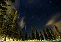
View of the night sky from Dole Park

See also
 In Spanish: Lanai City para niños
