
Langres facts for kids
Quick facts for kids
Langres
|
||
|---|---|---|

View of Langres
|
||
|
||

Langres
Location in France

Langres
Location in Grand Est
|
||
| Country | France | |
| Region | Grand Est | |
| Department | Haute-Marne | |
| Arrondissement | Langres | |
| Canton | Langres | |
| Intercommunality | Le Grand Langres | |
| Area
1
|
22.33 km2 (8.62 sq mi) | |
| Population
(2014)
|
7,850 | |
| • Density | 351.55/km2 (910.5/sq mi) | |
| Time zone | UTC+01:00 (CET) | |
| • Summer (DST) | UTC+02:00 (CEST) | |
| INSEE/Postal code |
52269 /52200
|
|
| Elevation | 327–475 m (1,073–1,558 ft) (avg. 401 m or 1,316 ft) |
|
| Website | www.langres.fr | |
| 1 French Land Register data, which excludes lakes, ponds, glaciers > 1 km2 (0.386 sq mi or 247 acres) and river estuaries. | ||

Langres is a commune of France and a subprefecture of the Haute-Marne department in northeastern France, in the Grand Est region.
Contents
Geography
The city of Langres is on the southen part of the Haute-Marne department in northeast France; the city is on a promontory that is in the north of the Plateau de Langres.
It has an area of 22.3 km2 (8.6 sq mi). Its average altitude is 401 m (1,316 ft); at the city hall, the altitude is 450 m (1,480 ft).
The distances from Langres to other cities are:
- Paris, the national capital - 294 km (183 mi);
- Strasbourg - 279 km (173 mi);
- Bordeaux - 779 km (484 mi);
- Toulouse - 804 km (500 mi);
- Montpellier - 565 km (351 mi);
- Lyon - 269 km (167 mi);
- Nantes - 635 km (395 mi);
- Marseille - 579 km (360 mi).
 |
The commune of Langres is surrounded by the communes Balesmes-sur-Marne, Champigny-lès-Langres, Chatenay-Mâcheron, Humes-Jorquenay, Peigney, Perrancey-les-Vieux-Moulins, Saint-Ciergues, Saint-Vallier-sur-Marne and Saints-Geosmes.
 |
Perrancey-les-Vieux-Moulins | Peigney | Peigney | |
| Saints-Geosmes | Peigney | |||
| Saints-Geosmes | Saints-Geosmes | Saint-Vallier-sur-Marne |
The Marne river flows through the commune of Langres.
Climate
The Köppen climate classification type for the climate at Langres is a "Marine West Coast Climate" and of the subtype "Cfb".
The average amount of precipitation for the year in Langres is 746.8 mm (29.4 in). The month with the most precipitation on average is December with 83.8 mm (3.3 in) of precipitation. The month with the least precipitation on average is August with an average of 40.6 mm (1.6 in).
The average temperature for the year in Langres is 9.7 °C (49.5 °F). The warmest month, on average, is July with an average temperature of 18.7 °C (65.7 °F). The coolest month on average is January, with an average temperature of 1.1 °C (34.0 °F).
| Climate data for Langres, France | |||||||||||||
|---|---|---|---|---|---|---|---|---|---|---|---|---|---|
| Month | Jan | Feb | Mar | Apr | May | Jun | Jul | Aug | Sep | Oct | Nov | Dec | Year |
| Average high °C (°F) | 3.4 (38.1) |
5.1 (41.2) |
9.4 (48.9) |
13.1 (55.6) |
17.4 (63.3) |
20.8 (69.4) |
23.5 (74.3) |
22.2 (72.0) |
18.9 (66.0) |
13.8 (56.8) |
7.6 (45.7) |
4.1 (39.4) |
13.3 (55.9) |
| Daily mean °C (°F) | 1.1 (34.0) |
2.2 (36.0) |
5.8 (42.4) |
8.9 (48.0) |
13.1 (55.6) |
16.3 (61.3) |
18.7 (65.7) |
18.6 (65.5) |
14.8 (58.6) |
10.5 (50.9) |
5 (41) |
1.9 (35.4) |
9.7 (49.5) |
| Average low °C (°F) | −1.3 (29.7) |
−0.7 (30.7) |
2.1 (35.8) |
4.6 (40.3) |
8.7 (47.7) |
11.7 (53.1) |
13.9 (57.0) |
13.9 (57.0) |
10.6 (51.1) |
7.2 (45.0) |
2.4 (36.3) |
−0.3 (31.5) |
6.1 (42.9) |
| Average rainfall mm (inches) | 77.1 (3.04) |
55 (2.2) |
57.5 (2.26) |
52 (2.0) |
67.5 (2.66) |
51.1 (2.01) |
55.4 (2.18) |
41.7 (1.64) |
61.8 (2.43) |
75.9 (2.99) |
68.2 (2.69) |
83.5 (3.29) |
746.7 (29.39) |
| Source: Weatherbase.com [1] | |||||||||||||
Population
The inhabitants of Langres are known, in French, as Langonais (women: Langonaises) or Langrois (women: Langroises).
The city of Langres has a population, in 2014, of 7,850 and its population density is of 352 inhabitants/km2.
Evolution of the population in Langres

Administration
Langres is a subprefecture of the Haute-Marne department, the capital of the arrondissement of Langres and the administrative centre (French: chef-lieu) of the canton Langres formed by 18 communes (including Langres), with 12,160 inhabitants (2014).
It is part of the intercommunality Le Grand Langres (French: Communauté de communes du Grand Langres).
Twinned and partner towns
Langres is twinned with:
 Beaconsfield, United Kingdom - since 1995.
 Ellwangen, Germany - since 1964.
 Abbiategrasso, Italy.
Gallery
-
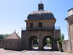
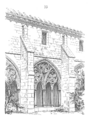
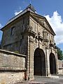
Porte des Moulins in the old city wall.
-
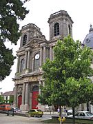
Saint-Mammès cathedral, Langres.
-
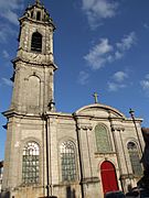
Saint-Martin church, Langres.
-
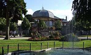
Claude-Henriot square.
-
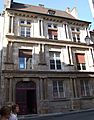
Renaissance house.


Related pages
Images for kids
-
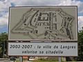
Road sign announcing improvements to the Citadel of Langres
-
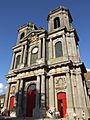
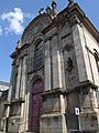
Saint-Mammès Cathedral
-
Saint-Mammès Cathedral
-
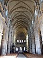
Saint-Mammès Cathedral
-
Saint-Mammès Cathedral
-
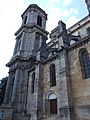
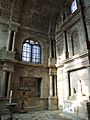
Saint-Mammès Cathedral Cloister
-
Saint-Mammès Cathedral Cloister
-
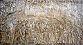
Bas relief at Saint-Mammès Cathedral
-
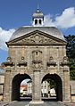
Moulins Gate
-
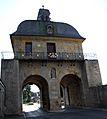
Moulins Gate
-
Moulins Gate
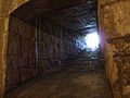
-
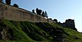
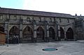
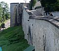
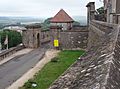
Ramparts of the Citadel
-
Ramparts and Funicular
-
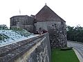
Saint-Ferjeux Tower
-
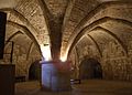
Navarre and d'Orval Tower
-
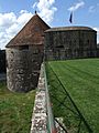
Navarre and d'Orval Tower
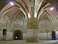
-
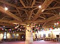
Navarre and d'Orval Tower ceiling framework
-

Navarre and d'Orval Tower torch holder
-
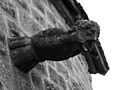
Navarre and d'Orval Tower gargoyle
-
Navarre and d'Orval Tower
-
Navarre and d'Orval Tower
-
Navarre and d'Orval Tower
-
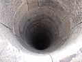
Navarre and d'Orval Tower well
-
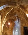
Navarre and d'Orval Tower vaulted arch
-
Former Jesuit College
-
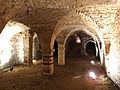
Renaissance cellar
-
Entrance to City Hall
-
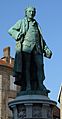
Statue of Denis Diderot
-
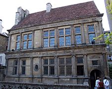
Renaissance period mansion


See also
 In Spanish: Langres (Alto Marne) para niños
