Lanham, Kansas and Nebraska facts for kids
Quick facts for kids
Lanham, Kansas and Nebraska
|
|
|---|---|

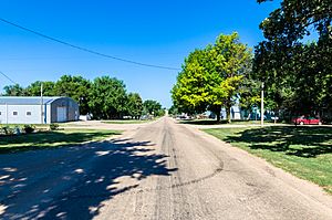
West State Line Road in Lanham. Left side is Kansas, right side is Nebraska. (2017)
|
|
| Country | United States |
| State | Kansas, Nebraska |
| County KS NE | Washington, Kansas, Gage, Nebraska |
| Elevation | 1,398 ft (426 m) |
| Time zone | UTC-6 (CST) |
| • Summer (DST) | UTC-5 (CDT) |
| ZIP code |
66945, 68415
|
| FIPS code | 31-38625 |
| GNIS ID | 485447 |
Lanham is an unincorporated community in both Washington County, Kansas and Gage County, Nebraska, United States. The Kansas-Nebraska state line runs down its main street. It is located along State Line Road, about 0.6 miles west of K-148/Nebraska Highway 112. Also, it is 7 miles north of Hanover, Kansas and 6.5 miles from Odell, Nebraska.
History
Lanham was named for a railroad official. A post office was opened in Lanham (on the Kansas side) in 1914, and remained in operation until it was discontinued in 1923.
- Washington County Kansas Maps: Current, Historic, KDOT

All content from Kiddle encyclopedia articles (including the article images and facts) can be freely used under Attribution-ShareAlike license, unless stated otherwise. Cite this article:
Lanham, Kansas and Nebraska Facts for Kids. Kiddle Encyclopedia.


