
Laravale, Queensland facts for kids
Quick facts for kids LaravaleQueensland |
|||||||||||||||
|---|---|---|---|---|---|---|---|---|---|---|---|---|---|---|---|

Round Mountain, 2016
|
|||||||||||||||

Laravale
Location in Queensland
|
|||||||||||||||
| Population | 189 (2016 census) | ||||||||||||||
| • Density | 3.310/km2 (8.57/sq mi) | ||||||||||||||
| Postcode(s) | 4285 | ||||||||||||||
| Area | 57.1 km2 (22.0 sq mi) | ||||||||||||||
| Time zone | AEST (UTC+10:00) | ||||||||||||||
| Location |
|
||||||||||||||
| LGA(s) | Scenic Rim Region | ||||||||||||||
| State electorate(s) | Scenic Rim | ||||||||||||||
| Federal Division(s) | Wright | ||||||||||||||
|
|||||||||||||||
Laravale is a rural locality in the Scenic Rim Region, Queensland, Australia. In the 2016 census, Laravale had a population of 189 people.
Education
There are no schools in Laravale. The nearest government primary school is Tamrookum State School in neighbouring Tamrookum to the south. The nearest government secondary school is Beaudesert State High School in Beaudesert to the north-east.
Images for kids
-
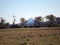
Mount Lindesay seen from Laravale, 2014
-
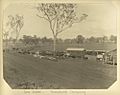
Lara station on the Beaudesert Tramway


All content from Kiddle encyclopedia articles (including the article images and facts) can be freely used under Attribution-ShareAlike license, unless stated otherwise. Cite this article:
Laravale, Queensland Facts for Kids. Kiddle Encyclopedia.