
Larksville, Pennsylvania facts for kids
Quick facts for kids
Larksville, Pennsylvania
|
|
|---|---|
|
Borough
|
|

Location of Larksville in Luzerne County, Pennsylvania.
|
|

Larksville, Pennsylvania
Location in Pennsylvania

Larksville, Pennsylvania
Location in the United States
|
|
| Country | United States |
| State | Pennsylvania |
| County | Luzerne |
| Incorporated | 1909 |
| Government | |
| • Type | Borough Council |
| Area | |
| • Total | 4.84 sq mi (12.54 km2) |
| • Land | 4.69 sq mi (12.15 km2) |
| • Water | 0.15 sq mi (0.39 km2) |
| Population
(2010)
|
|
| • Total | 4,480 |
| • Estimate
(2019)
|
4,385 |
| • Density | 934.97/sq mi (360.96/km2) |
| Time zone | UTC-5 (Eastern (EST)) |
| • Summer (DST) | UTC-4 (EDT) |
| Area code(s) | 570 |
| FIPS code | 42-41608 |
Larksville is a borough in Luzerne County, Pennsylvania, United States. It is 2 miles (3 km) west of Wilkes Barre on the Susquehanna River (along U.S. Route 11). The population was 4,480 as of the 2010 census.
Geography

Larksville is located at 41°15′31″N 75°55′38″W / 41.25861°N 75.92722°W (41.258525, -75.927176).
According to the United States Census Bureau, the borough has a total area of 4.9 square miles (12.6 km2), of which 4.7 square miles (12.2 km2) is land and 0.15 square miles (0.4 km2), or 3.24%, is water.
Demographics
| Historical population | |||
|---|---|---|---|
| Census | Pop. | %± | |
| 1880 | 454 | — | |
| 1910 | 9,288 | — | |
| 1920 | 9,438 | 1.6% | |
| 1930 | 9,322 | −1.2% | |
| 1940 | 8,467 | −9.2% | |
| 1950 | 6,360 | −24.9% | |
| 1960 | 4,390 | −31.0% | |
| 1970 | 3,937 | −10.3% | |
| 1980 | 4,410 | 12.0% | |
| 1990 | 4,700 | 6.6% | |
| 2000 | 4,694 | −0.1% | |
| 2010 | 4,480 | −4.6% | |
| 2019 (est.) | 4,385 | −2.1% | |
| Sources: | |||
As of the census of 2000, there were 4,694 people, 1,808 households, and 1,323 families residing in the borough. The population density was 986.0 people per square mile (380.7/km2). There were 1,939 housing units at an average density of 407.3 per square mile (157.3/km2). The racial makeup of the borough was 98.93% White, 0.28% African American, 0.04% Native American, 0.28% Asian, 0.13% from other races, and 0.34% from two or more races. Hispanic or Latino of any race were 0.70% of the population.
There were 1,808 households, out of which 32.1% had children under the age of 18 living with them, 56.3% were married couples living together, 12.6% had a female householder with no husband present, and 26.8% were non-families. 22.6% of all households were made up of individuals, and 11.7% had someone living alone who was 65 years of age or older. The average household size was 2.59 and the average family size was 3.05.
In the borough the population was spread out, with 23.4% under the age of 18, 7.2% from 18 to 24, 27.2% from 25 to 44, 26.7% from 45 to 64, and 15.5% who were 65 years of age or older. The median age was 40 years. For every 100 females, there were 94.4 males. For every 100 females age 18 and over, there were 91.9 males.
The median income for a household in the borough was $35,467, and the median income for a family was $41,211. Males had a median income of $33,993 versus $21,998 for females. The per capita income for the borough was $16,196. About 10.2% of families and 13.6% of the population were below the poverty line, including 19.1% of those under age 18 and 9.5% of those age 65 or over.
Notable people
- April Fronzoni, a field hockey striker from the United States
- Bryan Kocis, founder of Cobra Video
- Frank O'Connell, Pennsylvania State Representative and State Senator
- John Siegal, an American football player
- Joe Skladany, an American football player
- Leo Skladany, an American football player
Images for kids
-
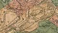
A map of Plymouth Township in 1864. The eastern part of the township became Larksville.
-
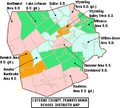
A map of Luzerne County school districts. Wyoming Valley West can be seen in orange (near central Luzerne County).


See also
 In Spanish: Larksville para niños
