
Laurel, Oregon facts for kids
Quick facts for kids
Laurel, Oregon
|
|
|---|---|

Laurel Valley Store
|
|

Laurel, Oregon
Location in Oregon

Laurel, Oregon
Location in the United States
|
|
| Country | United States |
| State | Oregon |
| County | Washington |
| Settled | 1872 |
| Elevation | 197 ft (60 m) |
| Time zone | UTC-8 (Pacific (PST)) |
| • Summer (DST) | UTC-7 (PDT) |
| GNIS feature ID | 1122976 |
Laurel is an unincorporated community in Washington County, Oregon, United States. Settled in 1872, the community is located between Hillsboro and Newberg, in the southern portion of the Tualatin Valley in the foothills of the Chehalem Mountains. The community retains its agricultural heritage. Laurel is served by the Hillsboro School District and includes the century-old Laurel Valley Store building, which is in the process of being turned into a restaurant. As an unincorporated community, Laurel has no defined boundaries or population statistics of its own.
History
When Euro-American settlers came to what is now Washington County, the area was inhabited by the Atfalati Native American group. Smallpox epidemics struck the Atfalati and by the mid-1830s, only 10 percent of the tribe was left. An 1855 government treaty removed the remaining Atfalati to the Grand Ronde Indian Reservation, where there are still about 20 individuals who identify themselves as Atfalati.
In 1872, the Mulloy family settled the area that is now Laurel. In May 1879, the Laurel post office was established with Alfred Mulloy, Sr. as postmaster. Mail was delivered once per week until 1881 when deliveries increased to twice per week. The population was 150 people in 1880, but dropped to 29 in the 1900 census.
The Laurel Valley Store was opened in 1893 by Gus, Maud, and Jacob Messinger. A small one-room schoolhouse was built later. A telephone line was extended to Laurel in 1904 from Hillsboro with four customers. The population grew to 50 residents in 1910. In 1923, Laurel Community Hall was constructed for about $5,000. The post office was closed in 1935.
Present
Laurel lost its post office, school, and its recognition as a town in the early 1900s. The community has several agricultural farms and plant nurseries, although most of its residents commute to Portland, Hillsboro, or Beaverton for work. The Laurel Valley School of Dance has provided dance lessons in the Laurel Hall for over 30 years. The old school building has been turned into the Laurel Apartments. Children attend schools in the Hillsboro School District, with Farmington View serving as the elementary school. Fire protection services are provided by Washington County Fire District 2.
The two main cross streets in Laurel are SW Laurel Road, and SW Campbell Road. These used to be Laurel Road North, Laurel Road South, Laurel Road East, and Laurel Road West. These were changed to their present name when the county got rid of the old route/box number of addresses and implemented the present street address system, which is more common in the western United States. Laurel is located along the Washington County Scenic Loop.
At the northwest corner of the main intersection in Laurel is the largest contiguous walnut orchard in Oregon's Washington County. Laurel Valley Store is located at the same intersection and has been in operation since 1893. The current two-story building was constructed in 1913.
Images for kids
-
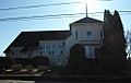
Church in the community

