
Lawrence County, Alabama facts for kids
Quick facts for kids
Lawrence County
|
|
|---|---|

Lawrence County Courthouse in Moulton
|
|

Location within the U.S. state of Alabama
|
|
 Alabama's location within the U.S. |
|
| Country | |
| State | |
| Founded | February 6, 1818 |
| Named for | James Lawrence |
| Seat | Moulton |
| Largest city | Moulton |
| Area | |
| • Total | 717 sq mi (1,860 km2) |
| • Land | 691 sq mi (1,790 km2) |
| • Water | 27 sq mi (70 km2) 3.7% |
| Population
(2020)
|
|
| • Total | 33,073 |
| • Estimate
(2021)
|
33,090 |
| • Density | 46.13/sq mi (17.810/km2) |
| Time zone | UTC−6 (Central) |
| • Summer (DST) | UTC−5 (CDT) |
| Congressional district | 4th |
|
|
Lawrence County is a county in the northern part of the U.S. state of Alabama. As of the 2020 census, the population was 33,073. The county seat is Moulton. The county was named after James Lawrence, a captain in the United States Navy from New Jersey.
Lawrence County is included in the Decatur, AL Metropolitan Statistical Area, which is also included in the Huntsville-Decatur-Albertville, AL Combined Statistical Area.
Contents
History
For thousands of years, this area was inhabited by differing cultures of indigenous peoples. People of the Copena culture in the Middle Woodland period (1-500 CE) built complex earthworks as part of their religious and political system. Their burial mound and ceremonial platform mound, the largest in the state, are preserved at Oakville Indian Mounds Park and Museum. The museum includes exhibits on the Cherokee, who inhabited the area at the time of European encounter. Other historic Native American tribes were Choctaw and Creek.
Lawrence County was established by European Americans on February 6, 1818. Under the Indian Removal Act of 1830, the U.S. government forced most tribes to go west to Indian Territory to the west of the Mississippi River, to make way for American settlers and development.
Numerous Cherokee and mixed-race European-Cherokee descendants, sometimes called "Black Dutch", have stayed in the Lawrence County area. The county has the highest number of self-identified Native Americans in the state, including 4,000 members of the Echota Cherokee Tribe of Alabama, which is state recognized.
Geography
According to the U.S. Census Bureau, the county has a total area of 717 square miles (1,860 km2), of which 691 square miles (1,790 km2) is land and 27 square miles (70 km2) (3.7%) is water.
River
Adjacent counties
- Limestone County (northeast)
- Morgan County (east)
- Cullman County (southeast)
- Winston County (south)
- Franklin County (west)
- Colbert County (west)
- Lauderdale County (northwest)
National protected area
- William B. Bankhead National Forest (part)
Transportation
Major highways

 U.S. Highway 72 Alternate
 Alabama 20
 Alabama 24
 Alabama 33
 Alabama 36
 Alabama 101
 Alabama 157
 Alabama 184
Rail
- Norfolk Southern Railway
Demographics
| Historical population | |||
|---|---|---|---|
| Census | Pop. | %± | |
| 1820 | 8,652 | — | |
| 1830 | 14,984 | 73.2% | |
| 1840 | 13,313 | −11.2% | |
| 1850 | 15,258 | 14.6% | |
| 1860 | 13,975 | −8.4% | |
| 1870 | 16,658 | 19.2% | |
| 1880 | 21,392 | 28.4% | |
| 1890 | 20,725 | −3.1% | |
| 1900 | 20,124 | −2.9% | |
| 1910 | 21,984 | 9.2% | |
| 1920 | 24,307 | 10.6% | |
| 1930 | 26,942 | 10.8% | |
| 1940 | 27,880 | 3.5% | |
| 1950 | 27,128 | −2.7% | |
| 1960 | 24,501 | −9.7% | |
| 1970 | 27,281 | 11.3% | |
| 1980 | 30,170 | 10.6% | |
| 1990 | 31,513 | 4.5% | |
| 2000 | 34,803 | 10.4% | |
| 2010 | 34,339 | −1.3% | |
| 2020 | 33,073 | −3.7% | |
| 2021 (est.) | 33,090 | −3.6% | |
| U.S. Decennial Census 1790–1960 1900–1990 1990–2000 2010–2020 |
|||
2010 census
At the 2010 census there were 34,339 people, 13,654 households, and 9,985 families living in the county. The population density was 50 people per square mile (19/km2). There were 15,229 housing units at an average density of 22 per square mile (8/km2). The racial makeup of the county was 77.6% White, 11.5% Black or African American, 5.7% Native American, 0.1% Asian, 0.0% Pacific Islander, 0.8% from other races, and 4.3% from two or more races. 1.7% of the population were Hispanic or Latino of any race. Of the 13,654 households 29.4% had children under the age of 18 living with them, 55.7% were married couples living together, 12.6% had a female householder with no husband present, and 26.9% were non-families. 24.2% of households were one person and 10.2% were one person aged 65 or older. The average household size was 2.50 and the average family size was 2.95.
The age distribution was 23.2% under the age of 18, 8.4% from 18 to 24, 24.8% from 25 to 44, 29.1% from 45 to 64, and 14.6% 65 or older. The median age was 40.6 years. For every 100 females, there were 95.7 males. For every 100 females age 18 and over, there were 97.4 males.
The median household income was $40,516 and the median family income was $48,425. Males had a median income of $45,787 versus $27,341 for females. The per capita income for the county was $19,370. About 10.3% of families and 13.6% of the population were below the poverty line, including 17.3% of those under age 18 and 11.0% of those age 65 or over.
2020 census
| Race | Num. | Perc. |
|---|---|---|
| White (non-Hispanic) | 24,714 | 74.73% |
| Black or African American (non-Hispanic) | 3,302 | 9.98% |
| Native American | 1,440 | 4.35% |
| Asian | 84 | 0.25% |
| Pacific Islander | 7 | 0.02% |
| Other/Mixed | 2,631 | 7.96% |
| Hispanic or Latino | 895 | 2.71% |
As of the 2020 United States census, there were 33,073 people, 12,677 households, and 9,101 families residing in the county.
Communities
Cities
- Moulton (county seat)
Towns
CDPs
Unincorporated communities
Places of interest
Lawrence County is home to part of the William B. Bankhead National Forest, Oakville Indian Mounds, and Jesse Owens Memorial Park. The Black Warrior Path, which starts in Cullman County, runs through this county and passes the Oakville Indian Mounds. It was used by Native Americans for hundreds of years, and was later used by pioneer settlers.
Events
Every year, Lawrence County hosts numerous events, including the AHSAA Cross Country state championships at the Oakville Indian Mounds, the Lawrence County Basketball Tournament in Moulton, and the Alabama Indian Festival at the Oakville Indian Mounds.
Education
Lawrence County is home to four high schools: East Lawrence High School (3A), Hatton High School (2A), Lawrence County High School (5A), and R.A. Hubbard High School (1A). Lawrence County also has six elementary schools and two middle schools. Other educational facilities include the Lawrence County Center of Technology and the Judy Jester Learning Center.
Former high schools, Hazlewood High School, Speake High School, and Mt. Hope High School were closed in 2009.
Images for kids
-
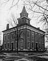
Old Lawrence County Courthouse
.jpg)
See also
 In Spanish: Condado de Lawrence (Alabama) para niños
